


WISPR SkyScout 2 Series: American-Made Precision Platforms for Survey, Mapping, and Enterprise UAV Operations
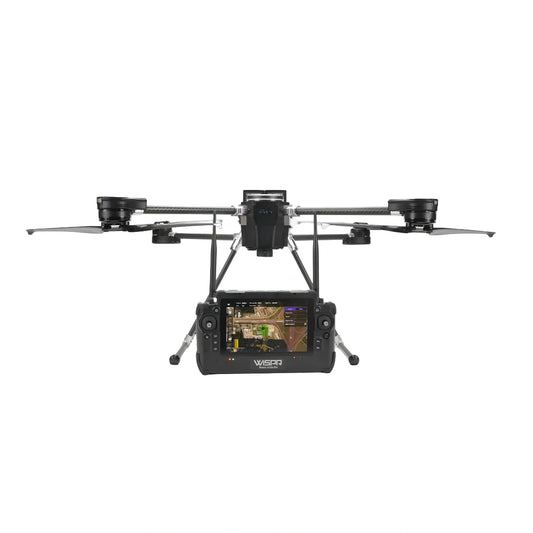
The WISPR SkyScout 2 Series represents a purpose-built approach to professional UAV operations — engineered in the United States, NDAA compliant, and listed on both the Blue UAS Cleared List and the Green UAS Program. Built around a proven quadcopter airframe with a sub-three-minute setup time, the SkyScout 2 Series is designed for operators who need a reliable, field-ready platform that performs consistently across demanding survey, mapping, inspection, and public safety deployments.
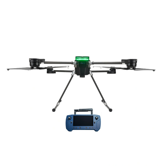
The series includes two configurations: the SkyScout 2 (Base Package) and the SkyScout 2+ (Premium Package). Both models share the same airframe, flight controller, GNSS system, battery architecture, and core platform features. The difference lies in the controller — and by extension, in the level of encryption, display ruggedness, and security clearance each configuration provides. Whether your operation calls for a proven Herelink-based setup or a fully ruggedized NDAA-cleared controller with AES-256 encryption, the SkyScout 2 Series offers a configuration to match.
SkyScout 2 vs. SkyScout 2+: Two Packages, One Proven Airframe
Both configurations are built on the same quadcopter platform with identical flight performance, GNSS capability, payload capacity, and field features. The table below maps the key differences between the two packages to help you select the right configuration for your mission requirements.
Scroll to view full table →
| Specification | Base Package SkyScout 2 | Premium Package SkyScout 2+ |
|---|---|---|
| Aircraft weight | 5.3 lbs. (2.4 kg) | 5.5 lbs. (2.5 kg) |
| Max takeoff weight | 12 lbs. (5.4 kg) | 12.2 lbs. (5.5 kg) |
| Max sustainable payload | 3.85 lbs. (1.75 kg) | 3.85 lbs. (1.75 kg) |
| Max flight time (no payload) | 35 min | 35 min |
| Max flight time (2.2 lb payload) | 30 min (+/- 2 min) | 30 min (+/- 2 min) |
| Max speed / wind rating | 50 MPH (80 km/h) | 50 MPH (80 km/h) |
| Operating temperature | -4°F to 122°F (-20°C to 50°C) | -4°F to 122°F (-20°C to 50°C) |
| Controller included | Herelink (Black or Blue) | WISPR SkyBoss Smart Controller |
| Controller display | 5.5" LCD, 1000 nits | 7" LCD, 2000 nits (sunlight readable) |
| Controller roll wheels | Single | Dual |
| Controller IP rating | — | IP55 |
| Controller drop test | — | MIL-STD-810 passed |
| Controller runtime | — | ~6 hr (hot-swappable batteries) |
| Transmission encryption | AES128 | AES-256 |
| Frequency | 2.4 GHz over LTE | 2.4 GHz and 5 GHz |
| Control range | 12 miles (19.3 km) | 5 miles (8 km) |
| Antennas | 2 | 4 |
| Extra GNSS antenna mount (LiDAR) | — | ✓ Included |
| NDAA compliant | ✓ | ✓ |
| Blue UAS Cleared | ✓ | ✓ |
| Green UAS Listed | ✓ | ✓ |
| Made in America | ✓ | ✓ |
Shared Flight Performance, GNSS, and System Architecture
Both SkyScout 2 configurations are powered by the same flight stack and GNSS system, delivering consistent positioning accuracy and field reliability regardless of which package you choose. The Cube Orange + flight controller runs WISPR Flight Firmware, a custom ArduPilot build developed and maintained by WISPR Systems. The Ublox ZED-F9P GNSS receiver supports RTK via NTRIP or RTCM correction services and PPK post-processing via WISPR Cloud, across four constellations on L1, L2, and E5 bands.
Scroll to view full table →
| Specification | Value — Both Models |
|---|---|
| Frame type | Quad Copter |
| Flight controller | Cube Orange + |
| Firmware | WISPR Flight Firmware (custom ArduPilot build) |
| Folded dimensions | 4.5" x 10" x 17" (11.4 cm x 25.4 cm x 43.2 cm) |
| Fully assembled dimensions | 14" x 24" x 24" (35.6 cm x 61 cm x 61 cm) |
| Diagonal wheelbase | 32.5" props folded; 49" props unfolded (82.6 cm / 124.5 cm) |
| Propeller size | 18.2" x 5.9" (46.2 cm x 15 cm) |
| Collision avoidance | Front, backward, downward |
| Terrain follow source | GNSS (high altitude); LiDAR Range Finder (low altitude) |
| I/O ports | MicroUSB (flight controller access); USB-C (GPS logs storage) |
| Orientation LED | Red (rear), White (front) |
| GNSS receiver | Ublox ZED-F9P |
| GNSS bands | L1, L2, and E5 |
| GNSS constellations | GPS + Galileo + GLONASS + BeiDou |
| IMU | Built-in 9-axis |
| RTK compatible | Yes — NTRIP or other RTCM services |
| PPK compatible | Yes — with WISPR Cloud Subscription |
| Battery configuration | 2 x WISPR Smart Batteries |
| Battery voltage | 22.8V |
| Battery capacity | 4350mAh (99.18 Wh) |
| Battery weight | 1.4 lbs. (630g +/- 20g) |
| Charging time | 45 minutes |
| Setup time | Under 3 minutes |
| Made in America | Yes |
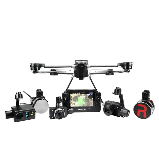
S Port Payload System, Compatible Payloads, and Ground Hardware
The SkyScout 2 Series uses the S Port quick-attach system to support a broad range of field-swappable payloads. All payloads connect via a single plug that carries both power and data, with no flight-time penalty for payloads up to 3.65 lbs. The table below lists the full compatible payload lineup by category.
Scroll to view full table →
| Category | Compatible Payload |
|---|---|
| Photogrammetry / Mapping | WISPR 24MP Mapper |
| Photogrammetry / Mapping | Sony LR1 (61MP) on Custom Gimbal — 35mm lens |
| Photogrammetry / Mapping | Sony LR1 (61MP) on Custom Gimbal — 50mm lens |
| Photogrammetry / Mapping | Sony LR1 (61MP) 35mm lens with 200m Laser Rangefinder |
| Agriculture / Multispectral | Sony LR1 Agrowing Sextuple Lens |
| Agriculture / Multispectral | Sony LR1 Agrowing Quad Lens |
| Agriculture / Multispectral | Micasense RedEdge-P |
| Agriculture / Multispectral | Micasense RedEdge-P Dual |
| Gimbal Platforms | Gremsy Zio (SkyScout) |
| Gimbal Platforms | Gremsy Vio F1 (SkyScout) |
| Gimbal Platforms | Gremsy Vio G1 (SkyScout) |
| LiDAR / Sensor — with FPV Gimbal | RESEPI Lite-M2X 24MP Camera |
| LiDAR / Sensor — with FPV Gimbal | RESEPI Avia Livox 24MP Camera |
| LiDAR / Sensor — with FPV Gimbal | RESEPI Ultra Lite-XT32 5MP Camera |
| LiDAR / Sensor — with FPV Gimbal | RESEPI Ouster REV7 OS1-64 26MP Camera |
| LiDAR / Sensor — no FPV Gimbal | RESEPI Teledyne EchoONE 5MP Camera |
| LiDAR / Sensor — no FPV Gimbal | RESEPI Gen-II Ouster OS1-64 61MP Camera |
All payloads connect via S Port quick-attach — single-plug power and data, no tools required. Maximum payload with no flight-time penalty: 3.65 lbs. Maximum sustainable payload: 3.85 lbs.
Ground support hardware available for the SkyScout 2 Series includes the SkyScout Battery Charger (45-minute charge time per battery pair), the SkyBoss Battery for the SkyScout 2+ package, and the WISPR Systems carry case with roll wheels and handle (32.4" x 18.5" x 10.85", 3.75 cu. ft., 17.6 lbs. empty, 37 lbs. fully loaded).
Core Platform Features and Capabilities
- S Port quick-attach system: single-plug power and data connection; supports payloads up to 3.65 lbs. with no flight-time penalty for fast field swaps
- TerrainSense altitude hold: high-accuracy altitude hold for mapping missions; reliable low-altitude terrain guidance when GPS or barometric data is unreliable
- SmartCore power system: redundant power distribution with battery-failure protection for consistent power delivery throughout the mission
- PathGuard obstacle sensing: front and rear detection to 164 ft (50 m) safeguards flight paths and return routes
- TempGuard thermal management: active airflow regulation keeps avionics within operating spec in extreme heat and cold
- SignalShield EMI shielding: advanced shielding protects avionics from electromagnetic interference near power lines and communication towers
- RTK positioning: NTRIP or RTCM-compatible for centimeter-level survey accuracy in the field
- PPK compatibility: enabled via WISPR Cloud Subscription for post-processed kinematic workflows
- Hot-swappable smart batteries: swap without powering down; 22.8V, 4350mAh (99.18 Wh), 45-minute charge time
- Airline-compliant batteries: fully compliant with commercial aviation regulations for site-to-site transport
- Battery safety systems: overcharge and discharge protection, temperature monitoring, cell balancing, storage mode, and auto-discharge
- Sub-three-minute deployment: from case to airborne in under three minutes
- NDAA compliant: both SkyScout 2 and SkyScout 2+ meet NDAA compliance requirements
- Made in America: designed and manufactured in the United States
Field Applications and Operational Use Cases
- Survey and mapping: RTK and PPK positioning with a broad payload lineup supports high-accuracy topographic, boundary, and site surveys
- Photogrammetry and orthomosaic production: compatible with multiple high-resolution imaging payloads for deliverable-ready aerial data
- LiDAR data collection: RESEPI payload compatibility enables point cloud capture for terrain modeling, corridor mapping, and volumetric analysis
- Multispectral and agricultural analysis: Micasense RedEdge-P and Sony LR1 Agrowing configurations support crop health monitoring and precision agriculture
- Infrastructure inspection: compact form factor and obstacle sensing support close-range inspection of structures, utilities, and infrastructure corridors
- Public safety operations: NDAA compliance, EMI shielding, and all-weather performance support law enforcement, first response, and government deployments
- Government and defense: Blue UAS Cleared and Green UAS Listed status satisfies procurement requirements for federal, state, and defense agency operations
- Construction progress monitoring: repeatable flight paths and RTK accuracy support as-built documentation and site progress tracking
Software Ecosystem and Workflow Integration
The SkyScout 2 Series operates on WISPR Flight Firmware, a custom ArduPilot build that powers the Cube Orange + flight controller on both configurations. Mission planning and ground control are handled through WISPR Ground Control, which also integrates with WISPR Cloud for PPK processing, data storage, and fleet management workflows.
PPK post-processing requires a WISPR Cloud Subscription and is complemented by the optional WISPR PPK Processing Upgrade (perpetual license) and WISPR PPK Photogrammetry Tool. For operations using RESEPI payloads, RESEPI PC Master Pro licenses are available in one-year, two-year, and perpetual tiers, with a SurveyPro Annual Module available as an add-on. A one-year RESEPI SLAM data processing license is available for LiDAR-specific workflows. The software stack is designed to carry data from flight through processing to final deliverable without requiring third-party tools for core workflows.
Scroll to view full table →
| Software / License | Description | Term |
|---|---|---|
| WISPR Ground Control | Mission planning and ground control software for the SkyScout 2 Series | Included |
| WISPR Cloud (Base) | Fleet management, data storage, and mission logging | Annual subscription |
| WISPR Cloud (PPK) | PPK post-processing and cloud-based kinematic workflow support | Annual subscription |
| WISPR PPK Processing Upgrade | Expanded PPK processing capability for the SkyScout platform | Perpetual |
| WISPR PPK Photogrammetry Tool | Photogrammetry processing tool for PPK-corrected aerial data | Perpetual |
| RESEPI PC Master Pro License | Point cloud processing software for RESEPI LiDAR payloads | 1 Year / 2 Year / Perpetual |
| RESEPI SLAM Data Processing | SLAM-based LiDAR data processing for RESEPI payload workflows | 1 Year |
| SurveyPro Annual Module | Add-on survey module for RESEPI PC Master Pro users | Annual |
Choosing the Right SkyScout 2 Configuration for Your Operation
- Choose SkyScout 2 (Base) if your operation uses established Herelink-based workflows, requires a 12-mile control range, and does not have specific controller-level encryption or Blue UAS Cleared controller requirements
- Choose SkyScout 2+ (Premium) if your operation requires a Blue UAS Cleared controller, AES-256 encryption at the controller level, MIL-STD-810 and IP55 ruggedization, or the extra GNSS antenna mount for LiDAR payload integration
- Choose LiDAR payloads (RESEPI series) if your deliverables require point cloud data, terrain modeling, or corridor mapping beyond what photogrammetry alone provides
- Choose RTK configuration if centimeter-level accuracy is required in real time, with a reliable NTRIP correction source available in the field
- Choose PPK configuration via WISPR Cloud if your sites lack consistent network coverage or if your workflow requires post-processed kinematic accuracy without real-time correction dependency
- Consider WISPR Training enrollment — training is required to activate the product warranty on SkyScout 2 Series platforms
The SkyScout 2 Series is a field-proven platform built for operators who need survey-grade accuracy, reliable payload integration, and procurement-ready compliance in a compact, American-made airframe. Both configurations ship with a ruggedized case, WISPR smart batteries, and a complete ground support kit ready for immediate deployment.
DSLRPros offers the full SkyScout 2 Series lineup — including both aircraft configurations, the complete modular payload ecosystem, accessories, software licenses, and service plans — so your team can configure the right platform for your mission from a single source.
Frequently Asked Questions
What is the difference between the SkyScout 2 and the SkyScout 2+?
Both models are built on the same quadcopter airframe and share identical flight performance, GNSS architecture, payload capacity, and platform features. The key difference is the included controller. The SkyScout 2 comes with a Herelink controller (Black or Blue), offering a 12-mile control range and AES128 encryption. The SkyScout 2+ includes the WISPR SkyBoss Smart Controller, which is NDAA-compliant, IP55-rated, MIL-STD-810 tested, and operates with AES-256 encryption. The SkyScout 2+ also includes an extra GNSS antenna mount for LiDAR payload integration and is specifically Blue UAS Cleared and Green UAS Listed at the controller level.
Is the SkyScout 2 Series NDAA compliant?
Yes. Both the SkyScout 2 and SkyScout 2+ are NDAA compliant and made in the United States. The SkyScout 2+ with its WISPR SkyBoss controller is additionally listed on the DCMA Blue UAS Cleared List and the Green UAS Program, satisfying procurement requirements for federal, state, and defense agency operations. The SkyScout 2 with Herelink controller is also listed as NDAA compliant, Blue UAS, and Green UAS on the WISPR product page.
What payloads are compatible with the SkyScout 2 Series?
The SkyScout 2 Series supports a broad range of field-swappable payloads via the S Port quick-attach system, which connects power and data through a single plug. Compatible payloads include photogrammetry cameras, high-resolution Sony LR1 configurations, Gremsy gimbal platforms, Micasense multispectral sensors, and the full RESEPI LiDAR payload lineup. All payloads weighing up to 3.65 lbs. can be carried with no flight-time penalty, and payloads up to the 3.85 lb. maximum sustainable limit are supported.
Does the SkyScout 2 support RTK and PPK workflows?
Yes. Both configurations include a Ublox ZED-F9P GNSS receiver capable of RTK positioning via NTRIP or other RTCM correction services for real-time centimeter-level accuracy. PPK post-processing is available on both models with a WISPR Cloud Subscription, and is further supported by the optional WISPR PPK Processing Upgrade and WISPR PPK Photogrammetry Tool for integrated post-processing workflows.
What software is required to fly and process data from the SkyScout 2 Series?
Flight operations are managed through WISPR Ground Control, which also handles mission planning. WISPR Cloud is used for PPK processing and data management and is required for PPK workflows. Operations using RESEPI payloads require RESEPI PC Master Pro, available in one-year, two-year, and perpetual license tiers. A SurveyPro Annual Module is available for PC Master Pro users, and a one-year RESEPI SLAM data processing license is available for LiDAR-specific deliverable workflows.
