


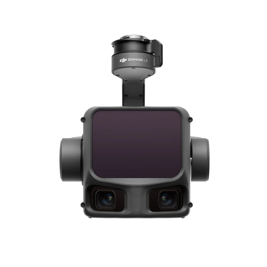

DJI Zenmuse L2 and Zenmuse L3 LiDAR camera payloads
High-accuracy aerial LiDAR payloads engineered for measurable performance, scalable coverage, and production-grade reliability
The DJI Zenmuse L2 and Zenmuse L3 represent two distinct tiers within DJI's professional aerial LiDAR portfolio, each designed to meet specific operational scales and accuracy requirements. Both payloads integrate LiDAR sensing, inertial positioning, RGB mapping cameras, and stabilized gimbal control into factory-calibrated systems that reduce operational complexity while delivering survey-grade outputs.
While the Zenmuse L2 focuses on efficiency and versatility for routine professional mapping, the Zenmuse L3 is DJI's most advanced LiDAR system to date, engineered for long-range detection, large-area coverage, and high-throughput geospatial production.
DJI Zenmuse L2 and Zenmuse L3 LiDAR Payloads
The Zenmuse L-series represents DJI’s enterprise LiDAR payload lineup for high-accuracy mapping, corridor surveys, and infrastructure inspection. Zenmuse L2 and Zenmuse L3 share a common goal—accurate point cloud generation tightly integrated with DJI aircraft and software—but they are designed for very different operational scales and mission profiles.
Zenmuse L2 is positioned as a versatile, lower-weight LiDAR + RGB mapping solution compatible with multiple Matrice platforms, making it a strong fit for general surveying, topographic mapping, and mixed-mission operators. Zenmuse L3, by contrast, is engineered for maximum performance on the Matrice 400 platform, emphasizing longer detection ranges, higher-resolution RGB capture, expanded return behavior, and specialized inspection scenarios such as utility wire detection.
| Comparison Area | Zenmuse L2 | Zenmuse L3 |
|---|---|---|
| Primary use case | General LiDAR mapping, topographic surveys, corridor mapping, and RGB-assisted point cloud capture with balanced payload weight. | Large-scale mapping, long-range LiDAR acquisition, utility and powerline inspection, and high-resolution RGB mapping. |
| Aircraft compatibility | Matrice 300 RTK, Matrice 350 RTK, and Matrice 400. | Matrice 400 only (requires Zenmuse L3 single gimbal connector). |
| LiDAR range profile | Effective for medium-range surveys with detection ranges up to 500 m under specified conditions. | Designed for extended-range operations, supporting significantly longer detection distances and wire detection scenarios. |
| Point cloud accuracy behavior | Optimized for high-accuracy mapping at typical survey altitudes around 150 m. | Maintains controlled accuracy across wider altitude bands, including higher-altitude missions up to 300 m. |
| RGB mapping capability | Integrated 20 MP 4/3 CMOS camera for colorized point clouds and orthomosaic workflows. | Advanced RGB mapping with up to 100 MP still capture and a higher-durability mechanical shutter. |
| Data handling and workflow | microSD-based field workflow with DJI Terra for post-processing. | High-throughput CFexpress workflow designed for large datasets and extended DJI software integration. |
| Payload weight & power | Lighter payload and lower typical power draw, suitable for longer endurance on compatible platforms. | Heavier, higher-power payload optimized for maximum output on the Matrice 400. |
Platform compatibility and deployment considerations
Compatibility is a key differentiator between the two payloads and should be evaluated early in system planning.
Zenmuse L3 compatibility:
-
Exclusively compatible with DJI Matrice 400
Zenmuse L2 compatibility:
- DJI Matrice 400
- DJI Matrice 350 RTK
- DJI Matrice 300 RTK (requires DJI RC Plus)
This distinction makes the Zenmuse L3 a dedicated solution for next-generation Matrice 400 deployments, while the Zenmuse L2 remains a flexible option for existing M300 and M350 fleets.
Zenmuse L3: long-range LiDAR and high-volume mapping at scale
The Zenmuse L3 is DJI's first long-range, high-accuracy aerial LiDAR system, designed for large-area surveying, corridor mapping, and complex terrain reconstruction where efficiency and penetration are critical.
Key LiDAR performance figures:
- 1535 nm long-range LiDAR wavelength
- Maximum detection range up to 950 m at 10% reflectivity
- Typical operating altitudes between 300 m and 500 m
- Maximum pulse emission frequency up to 2 million points per second
- Support for up to 16 returns per pulse
- Beam divergence of 0.25 mrad (1/e), approximately one-fifth the spot size of Zenmuse L2
These figures enable detection of fine features such as power lines and branches while significantly improving ground point density beneath vegetation.
Scanning flexibility:
- Linear scanning for uniform, high-accuracy terrain mapping
- Star-shaped scanning for balanced penetration in forests and urban areas
- Non-repetitive scanning for complex structures and power line inspection
Dual 100MP RGB mapping cameras integrated into Zenmuse L3
Zenmuse L3 integrates dual 100-megapixel RGB mapping cameras, each built around a 4/3 CMOS sensor with a mechanical shutter.
Camera system highlights:
- Dual 100MP sensors with pixel binning to effective 25MP
- Mechanical shutters eliminate rolling shutter distortion
- 107° horizontal field of view
- Ground sample distance of 3 cm at 300 m altitude
- Simultaneous LiDAR and RGB capture for DEM and DOM generation
The ultra-wide field of view allows efficient data capture even with reduced side overlap, improving productivity while maintaining accuracy.
Accuracy, positioning, and data quality with Zenmuse L3
Zenmuse L3 integrates a high-precision proprietary POS system with factory calibration.
Measured accuracy figures:
- Heading accuracy: 0.02°
- Pitch accuracy: 0.01°
- Ranging repeatability: 5 mm at 150 m
- Vertical accuracy:
- Better than 3 cm at 120 m altitude
- Better than 5 cm at 300 m altitude
- Better than 10 cm at 500 m altitude
These characteristics support mapping scales of 1:500, 1:1000, and 1:2000 while producing point clouds with approximately half the thickness of Zenmuse L2.
Operational efficiency:
- Up to 10 sq. km covered in a single flight at 300 m
- Up to 100 sq. km of high-accuracy mapping per day when paired with Matrice 400
Zenmuse L2: efficient, survey-grade LiDAR for everyday professional use
The Zenmuse L2 is a compact, frame-based LiDAR system designed to deliver precise results with lower operational thresholds.
Key LiDAR performance figures:
- Detection range:
- 250 m at 10% reflectivity
- 450 m at 50% reflectivity
- Operational altitude up to 120 m
- Support for up to 5 returns
- Effective point cloud rate up to 240,000 points per second
- Reduced laser spot size for improved vegetation penetration
Accuracy specifications:
- Vertical accuracy: 4 cm
- Horizontal accuracy: 5 cm
These figures make the L2 suitable for land surveying, forestry management, electricity corridor mapping, and infrastructure inspection.
RGB mapping camera integrated into Zenmuse L2
The Zenmuse L2 includes a professional RGB mapping camera designed for photogrammetry and contextual documentation.
Camera specifications:
- 4/3 CMOS sensor
- 20 megapixels
- Mechanical shutter
- Pixel size: 3.3 μm
- Maximum resolution: 5280 × 3956
Fast capture intervals and high shutter durability support extended operations and reduce long-term operating costs.
Workflow, processing, and operational tools
Both payloads integrate tightly with DJI Pilot 2 and DJI Terra.
Operational capabilities include:
- Real-time point cloud preview and coloring
- Pre-flight density and distribution estimation
- On-site playback and verification
- One-click LiDAR and RGB processing
- PPK processing support using D-RTK 3 or standard base station data
Advanced modeling and application support includes:
- Fusion-based LiDAR and RGB modeling
- DEM, DOM, contour, TIN, and mesh generation
- Semantic classification and profile analysis via DJI Modify
Choose the right Zenmuse LiDAR solution with DSLRPros
The Zenmuse L2 and Zenmuse L3 address different mission scales but share a commitment to measurable accuracy, integrated workflows, and professional reliability. DSLRPros supports enterprise teams with system matching, deployment planning, and long-term technical support.
Explore Zenmuse L2 and Zenmuse L3 LiDAR solutions at DSLRPros and equip your fleet with a production-ready aerial LiDAR platform built for real-world results.
