


DJI Zenmuse L3: Survey-Grade LiDAR Sensor for Matrice 400
DJI Zenmuse L3: Survey-Grade LiDAR Sensor for Matrice 400
SKU:S-DJI-ZL3


- Description
- Specifications
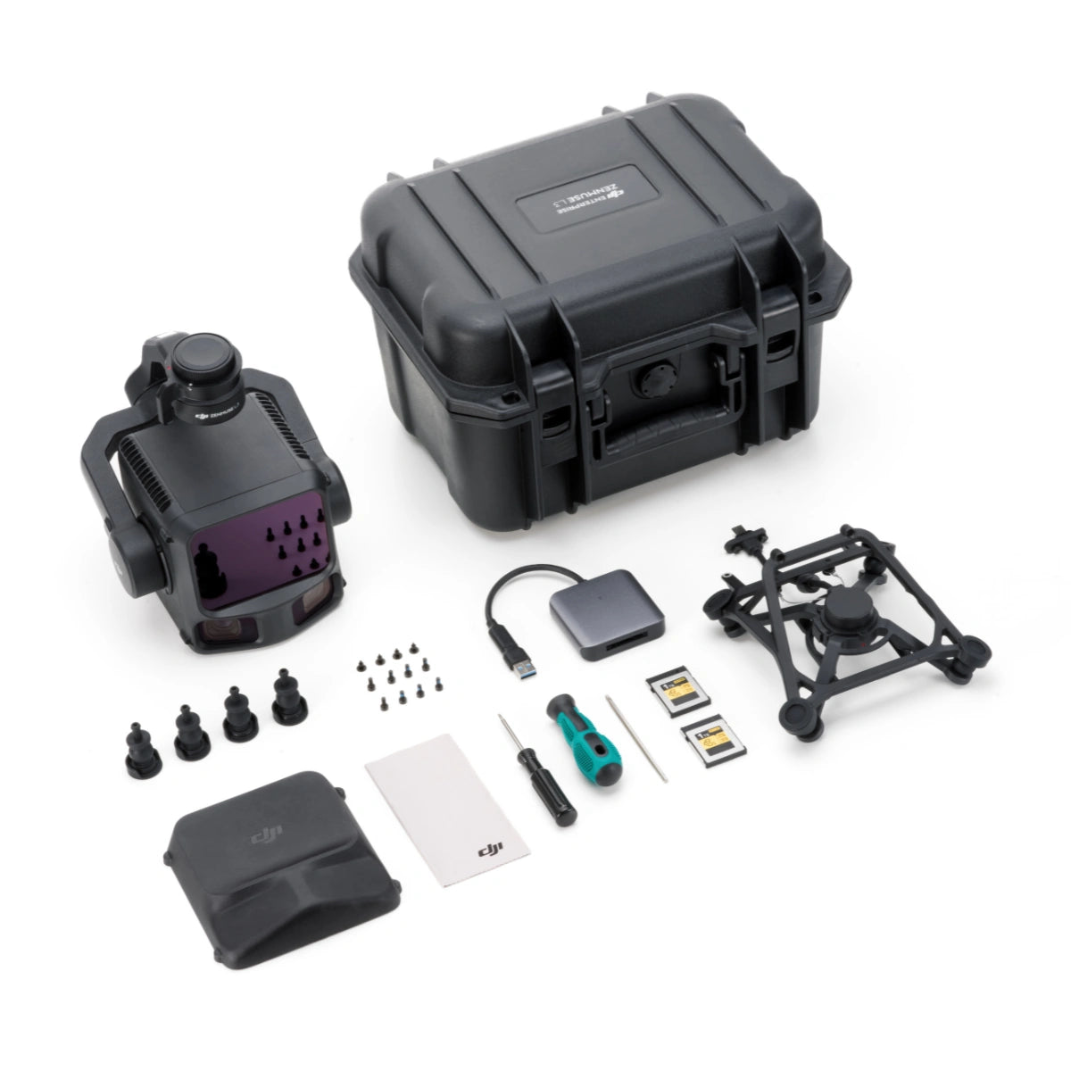
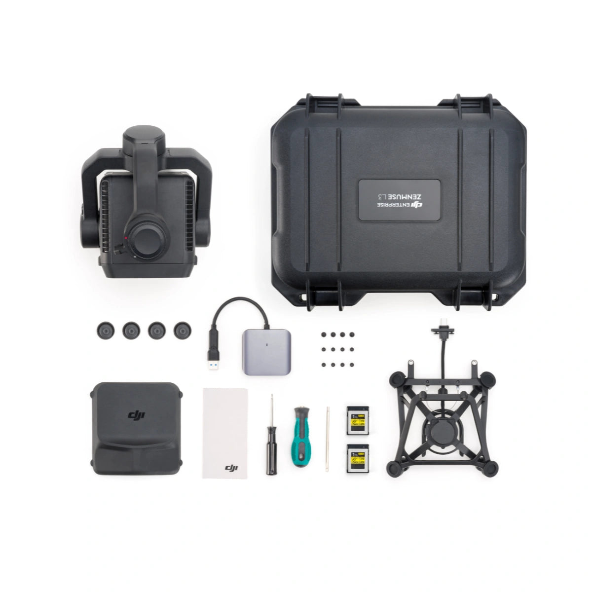
- In the Box
- FAQ
DJI Zenmuse L3: Long-Range LiDAR and Dual 100 MP Camera Payload for Survey-Grade Mapping
The DJI Zenmuse L3 is a long-range LiDAR and dual 100 MP mapping payload designed for survey-grade aerial mapping, topographic surveys, infrastructure inspection, and digital twin creation.
Built for the DJI Matrice 400 RTK, it delivers up to 950 m LiDAR range, 2–4 cm accuracy, and high-density point cloud capture, helping surveyors and engineers map larger areas faster with fewer flights.
Equipped with a 1535 nm Class 1 laser and dual 100 MP Micro 4/3 cameras, it delivers up to 950 m range and 2–4 cm accuracy for professional surveying and digital-twin applications.
Additionally, the L3 integrates seamlessly into DJI Terra workflows to output point clouds, orthophotos, and 3D models—all within a single processing environment.
Quick Look
- Long-range LiDAR system: 950 m @ 10% (100 kHz) and 700 m @ 10% (350 kHz).
- High-efficiency mapping: covers up to 10 km² per flight or 100 km² per day
- Survey-grade accuracy: delivers 2–4 cm precision for mapping applications.
- Adjustable point-rate control: 100 kHz – 2 MHz to balance density and coverage.
- Configurable returns: 16 (100 / 350 kHz), 8 (1000 kHz), 4 (2000 kHz).
- Dual 100 MP Micro 4/3 cameras: generate orthophotos and colorized point clouds.
- Real-time point-cloud preview: measure points, lines, and areas in DJI Pilot 2.
- Compact low-power design: 1.6 kg payload draws only 64 W typical power.
- Rugged environmental build: IP54 rated for –20 °C to +50 °C operation.
- Streamlined workflow: integrates directly with DJI Terra and Modify.
- DJI Care Enterprise Plus: 1-Year coverage activated upon first use.

Exceptional Range, Accuracy, and Efficiency
The Zenmuse L3 combines long-distance LiDAR reach with exceptional spatial precision. Its reduced 41 mm beam diameter and 0.25 mrad divergence produce higher-resolution point clouds and finer target separation.
Adjustable scanning rates from 100 kHz to 2 MHz, plus up to 16 returns, provide flexibility for both dense urban modeling and deep vegetation mapping.
With a no-preheat IMU, 0.01° pitch/roll and 0.02° heading accuracy, and auto-calibration during flight, the L3 ensures every mission begins instantly and captures consistent, high-integrity data.
Integrated Dual Cameras and All-Weather Reliability
Dual 100 MP Micro 4/3 sensors with 107° FOV capture ultra-sharp color imagery for photogrammetry and point-cloud colorization. The system delivers 1.2 cm GSD at 120 m AGL or 3 cm GSD at 300 m, ensuring photorealistic results for engineering-grade mapping.
The IP54-rated housing withstands rain, dust, and temperature extremes from -25 °C to +55 °C. P
owered by DJI’s unified ecosystem, the L3’s workflow with DJI Terra and Modify offers real-time point-cloud preview, on-site measurement, and automated accuracy checks—all backed by 1-Year DJI Care Enterprise Plus coverage.
Compatibility and Integration
- Supported aircraft: DJI Matrice 400 RTK only.
- Mounting system: DJI Skyport quick-plug single-port gimbal bracket.
- Dimensions: 192 × 162 × 202 mm.
- Data formats: LAS / LAZ point cloud, orthophoto, 3D model outputs.
- Software: DJI Terra for processing, DJI Modify for editing and analysis.
- Positioning integration: RTK / PPK fusion for high-precision georeferencing.
- Scanning modes: linear, star-shaped, non-repetitive patterns for terrain types.
- Storage media: CF-Express Type B cards with included card reader.
Zenmuse L3 Processing & Software Access
Zenmuse L3 LiDAR point cloud projects can be processed in DJI Terra without requiring any additional authorization. Simply log in to DJI Terra with any DJI account to begin reconstruction.
Each Zenmuse L3 also includes a complimentary 3-month DJI Modify subscription. The subscription activation details are automatically sent via email or SMS to the email address or phone number used during L3 activation.
Applications and Use Cases
- Power line and tower inspection: maps infrastructure with centimeter-level precision.
- Open-pit mine surveying: records depth changes and volumes up to 830 m.
- Forestry and vegetation mapping: penetrates dense canopies for terrain analysis.
- Topographic and engineering mapping: generates accurate DEM and as-built models.
- Archaeological documentation: reveals subsurface patterns and heritage structures.
- Geological hazard monitoring: tracks landslides and erosion in 3D context.
- Urban planning and digital twin creation: produces high-fidelity 3D data assets.
- Structural inspection: models bridges, dams, and steel frameworks in detail.
- Emergency response mapping: enables on-site area and volume measurement.
- Environmental research: supports hydrology and biomass monitoring.
Zenmuse L3 vs Zenmuse L2: Spec-Based Comparison for Enterprise LiDAR Buyers
Use this comparison to align the right LiDAR payload to your deliverables. Key decision drivers are operating altitude, corridor requirements, detection range, return performance, RGB detail, and data handling workflow.
| Category | Zenmuse L3 | Zenmuse L2 |
|---|---|---|
| Primary role | High-altitude, long-range LiDAR for infrastructure and large-area coverage | Survey-grade LiDAR mapping with integrated RGB |
| Supported aircraft | DJI Matrice 400 only (requires Zenmuse L3 single gimbal connector) | Matrice 400, Matrice 350 RTK, Matrice 300 RTK (requires DJI RC Plus) |
| Dimensions (L×W×H) | 192×162×202 mm | 155×128×176 mm |
| Weight | 1.60 kg (without connector) + 145 g single gimbal connector | 905±5 g |
| Power (typical / max) | 64 W / 100 W | 28 W / 58 W |
| Ingress protection | IP54 | IP54 |
| Operating temperature | -20° to 50° C (-4° to 122° F) | -20° to 50° C (-4° to 122° F) |
| Storage temperature | -40° to 70° C (-40° to 158° F) | -20° to 60° C (-4° to 140° F) |
| System accuracy (typical) | At 120 m: Vertical 3 cm (RMSE), Horizontal 4 cm (RMSE) At 300 m: Vertical 5 cm (RMSE), Horizontal 7.5 cm (RMSE) |
Horizontal: 5 cm @150 m Vertical: 4 cm @150 m |
| Point cloud thickness | 1.2 cm @1σ (120 m nadir) 2 cm @1σ (300 m nadir) |
Not specified |
| LiDAR wavelength | 1535 nm | 905 nm |
| Detection range (provided test conditions) | 700 m @10% reflectivity, 350 kHz 950 m @10% reflectivity, 100 kHz 2000 m @80% reflectivity, 100 kHz |
450 m @50% reflectivity, 0 klx 250 m @10% reflectivity, 100 klx Max detection range: 500 m |
| Wire detection range | 21.6 mm steel core aluminum stranded wire: 300 m @100 klx, 350 kHz 18.4 mm black PVC insulated wire: 100 m @100 klx, 350 kHz |
Not specified |
| Point cloud rate / pulse options | Pulse rates: 100 kHz / 350 kHz / 1000 kHz / 2000 kHz Recommended altitude: <500 m (100 kHz), <300 m (350 kHz), <100 m (1000 kHz), <50 m (2000 kHz) |
Single return: up to 240,000 pts/s Multiple returns: up to 1,200,000 pts/s Laser pulse emission frequency: 240 kHz |
| Returns supported | Up to 16 returns (100/350 kHz), up to 8 returns (1000 kHz), 4 returns (2000 kHz) | Up to 5 returns |
| Scanning modes | Linear, Star-shaped, Non-repetitive | Non-repetitive scanning pattern, Repetitive scanning pattern |
| LiDAR FOV | Linear: H80° / V3° Star-shaped: H80° / V80° Non-repetitive: H80° / V80° |
Repetitive: H70° / V3° Non-repetitive: H70° / V75° |
| RGB mapping camera | 4/3 CMOS, up to 100 MP (dual camera system specified separately as combined FOV) | 4/3 CMOS, 20 MP |
| RGB FOV | Combined horizontal FOV (dual RGB cameras): 107° | 84° |
| RGB resolution | 100 MP: 12288×8192 25 MP: 6144×4096 |
Photos: 5280×3956 (20 MP) |
| Mechanical shutter durability | 500,000 actuations | 200,000 actuations |
| Storage media | CFexpress Type B (sequential write 1500 MB/s) | microSD (UHS-I U3, up to 256 GB) |
| Processing and formats | DJI Terra export: PNTS/LAS/LAZ/PLY/PCD/S3MB DJI Modify import: LAS |
DJI Terra export: PNTS/LAS/PLY/PCD/S3MB |
Selection guide
- Choose Zenmuse L2 for standard mapping altitudes, lighter payload power/weight, and flexible aircraft support across Matrice 300/350/400.
- Choose Zenmuse L3 for longer detection range, high-altitude mapping efficiency, explicit wire detection, higher return counts, and higher-resolution RGB capture.
- Choose based on workflow: microSD capture is simpler for smaller teams, while CFexpress capture is optimized for high-volume datasets.
If you want help selecting the right payload for your mission profile, DSLRPros can walk through your altitude targets, corridor requirements, and processing workflow to match the best LiDAR configuration to your deliverables.
The DJI Zenmuse L3 LiDAR Camera is engineered for seamless enterprise adoption. Its unified DJI Terra workflow reduces data transfer and supports real-time accuracy checks.
Rugged construction, precision IMU stability, and fast setup make it ideal for surveying teams and industrial operators working in challenging conditions. Every component is optimized for reliability and repeatable results in professional missions.
Zenmuse L3 sets a new standard for survey-grade airborne LiDAR, combining long-range performance, dual-camera clarity, and all-weather reliability. It empowers surveyors, inspectors, and engineers to collect accurate, high-density data with unmatched efficiency.
