


Indoor Drones: UAVs Built to Operate Where GPS Cannot Reach
The environments that most demand aerial intelligence are often the ones that defeat conventional drones before they leave the ground. Storage tanks, bridge interiors, building voids, tunnels, and tactical structures share a common characteristic — no GPS signal — and that single condition is enough to make most professional UAVs unreliable or uncontrollable. Indoor drones are built around this reality. Instead of depending on satellite positioning, they use onboard sensing systems to build a spatial reference from the physical environment, holding position and navigating obstacles in conditions where standard platforms cannot safely operate.
DSLRPros carries two platforms in this category: the Terra Xross 1 from TerraDrone, a Japan-made confined space inspection drone built around LiDAR stabilization and 3D data capture, and the Vantage Robotics Trace, a USA-built nano UAV designed for rapid tactical deployment, encrypted ISR, and covert observation. Both operate without GPS. Beyond that, they serve fundamentally different mission profiles — and selecting between them starts with understanding what each one is actually built to do.
How Indoor Drones Maintain Stable Flight Without GPS
Outdoor UAVs use satellite positioning as their primary spatial reference. Take that away and most platforms lose the ability to hold position, execute autonomous routes, or recover from disturbance. Indoor drones solve this by reading the environment directly.
LiDAR-based systems scan their surroundings continuously, building a real-time 3D point cloud that the flight controller uses in place of GPS coordinates. Visual position systems use downward-facing cameras and optical flow sensors to track surface patterns beneath the aircraft, maintaining stable hover even in complete darkness when paired with onboard illumination. Both approaches produce controllable, stable flight in enclosed environments — they differ in the density of spatial data they generate, the environments they handle best, and the mission outputs they support.
Indoor Drones Available at DSLRPros
Terra Xross 1 — TerraDrone
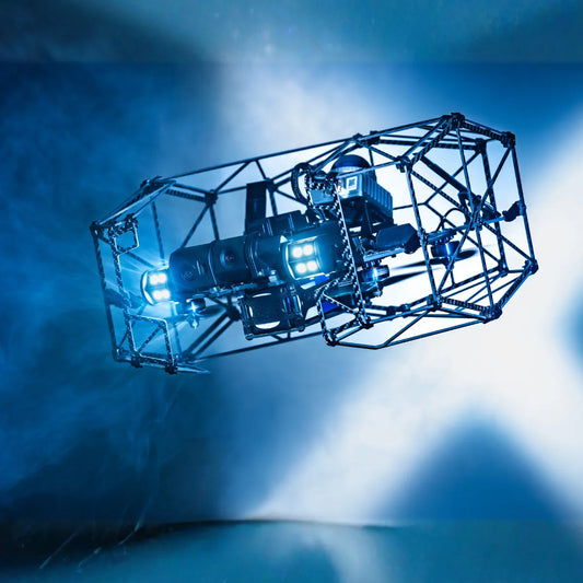
The Terra Xross 1 is a purpose-built industrial inspection drone designed to operate in the confined, GPS-denied environments that inspection professionals most need to access and least want to send personnel into. Built in Japan by TerraDrone and distributed through UAS VoSS, it uses a Class 1 LiDAR system as its primary stabilization reference, scanning at 200,000 points per second and 10 Hz to hold position against walls, ceilings, and structural elements without any satellite input. A supplementary visual odometry sensor adds a second stabilization layer for changing conditions.
The aircraft carries a fixed 4K camera with 180° tilt, dual LED arrays producing 10,480 lumens maximum for imaging in complete darkness, and a full-surround protective cage that absorbs contact with surfaces during close-quarters flight. The same LiDAR system that stabilizes the aircraft also generates the inspection data — real-time 3D point cloud output that Terra Xross Cloud links directly to captured still images and video, giving inspection teams a spatially indexed record of every finding rather than an unorganized image library. Tethering to an external power pack is supported for operations requiring flight duration beyond the 10-minute battery-only limit.
- Weight: 1,800 g (3.97 lb) including battery
- Size: 36 cm × 31 cm × 21 cm (14.2 in × 12.2 in × 8.3 in)
- Flight time: 10 minutes battery-only; tethered power option available
- Max speed: 2.5 m/s (8.2 ft/s)
- Wind resistance: 3 m/s (9.8 ft/s)
- Operating temperature: 0°C–45°C (32°F–113°F)
- LiDAR: Class 1; 200,000 points/sec; 10 Hz; range 40 m (131 ft) @ 10% reflectivity / 70 m (230 ft) @ 80% reflectivity; 2 cm precision @ 10 m
- Camera: 1/1.7-inch 8MP; 4K (3840×2160); 180° tilt; auto mode
- Lighting: 10,480 lumen maximum; dual integrated LED arrays
- Communication: 2.4 GHz ISM; Terra Xross Range Extender available for signal-obstructed environments
- Cloud platform: Terra Xross Cloud — links images and video to 3D LiDAR data; first year of Basic 500GB included
- Accessories carried: spare battery, battery charger, motor set (4 pcs), propellers (1 set), replacement cage, Terra Xross Range Extender, Terra Xross Cloud Basic 500GB (after first year), Terra Xross Cloud Additional Storage (500GB)
Vantage Robotics Trace — Public Safety Bundle
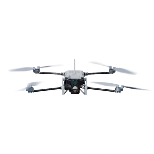
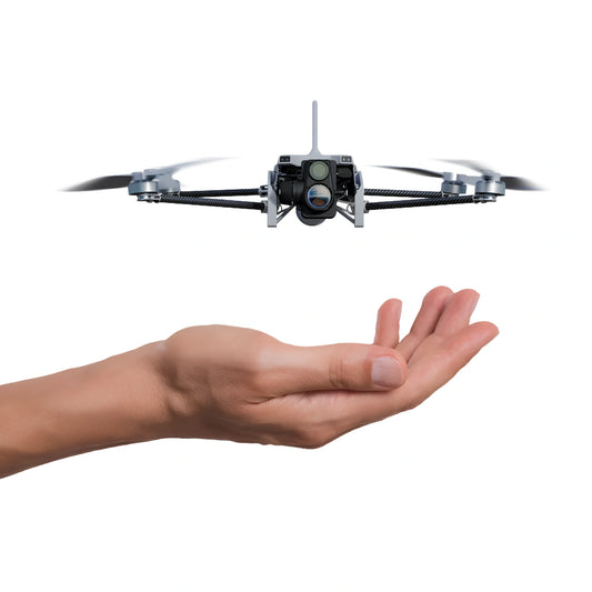
The Vantage Robotics Trace is a nano UAV designed for field operators who need aerial intelligence without the size, weight, or setup time of conventional platforms. Designed, sourced, and built in the USA, it weighs 153 g, folds into an IP67 field case that fits in a backpack alongside two batteries and the Vision2 GCS — total system weight under 1,000 g — and deploys by hand in 30 seconds. It is NDAA compliant with DoD Blue UAS pending, and carries AES-256 encryption across all communications and data storage with no remote data transmission.
The 2-axis stabilized Wisp EO/IR gimbal carries a 48MP electro-optical camera with an f/1.8 autofocus lens and 25× digital zoom, alongside a 320×240 uncooled VOx IR thermal sensor. Visual position control and an integrated scene illuminator maintain stable flight in GPS-denied environments without LiDAR. Obstacle avoidance keeps the aircraft clear of surfaces in confined spaces and structures. At under 37 dBA at 25 m and not visible at 30 ft against terrain, it operates without announcing its presence — a characteristic that matters in tactical and public safety deployments where covert observation is a mission requirement.
- Airframe weight: 153 g takeoff weight
- System weight: under 1,000 g with field case, 2 batteries, and Vision2 GCS
- Flight time: 36 minutes
- Top speed: 52 kph (32 mph)
- Wind resistance: up to 25 knots
- Operating temperature: -20°C–45°C (-4°F–113°F)
- Ingress protection: IP53 (aircraft); IP67 (field case)
- Acoustic signature: under 37 dBA at 25 m
- LOS range: 6 km; NLOS range: 500 m (30 dBi attenuation)
- EO camera: 48MP; f/1.8 autofocus; 25× digital zoom (67°–2.7° HFOV); 8,000 × 6,000 px stills; 1080p or 4K MPEG-4
- Thermal sensor: 320×240 uncooled VOx IR; 24° or 57° HFOV
- Gimbal: 2-axis stabilized; pitch -90° to +70°
- Security: AES-256 encryption; no remote data transmission; NDAA compliant; DoD Blue UAS pending
- GCS compatibility: QGC, ATAK, WMI, RAC2; MAVLink and RAS-A compliant
- Controller compatibility: Vantage Vision 2, Kutta KTAC, S20 TE, Tomahawk Mimic or Grip GCS
Operational Applications for Indoor and GPS-Denied UAVs
- Confined space inspection: storage tanks, pressure vessels, bridge voids, and enclosed structural cavities where personnel access is restricted or hazardous
- Industrial facility inspection: ductwork, machinery housings, process equipment interiors, and enclosed mechanical systems requiring documented visual data
- Public safety and law enforcement: pre-entry reconnaissance, building clearing support, and indoor situational awareness for tactical teams
- Search and rescue: thermal and EO imaging to locate subjects in smoke-filled, dark, or structurally compromised interiors
- Government and defense ISR: GPS-denied reconnaissance in structures, tunnels, and contested environments requiring NDAA-compliant hardware
- Post-incident documentation: rapid interior assessment following fires, structural incidents, or hazardous material events where direct personnel access is unsafe
Selecting the Right Indoor Drone for Your Mission
- Inspection data requirement: if the mission requires 3D spatial data, point cloud output, and indexed inspection records, the Terra Xross 1 is the purpose-matched platform; it generates LiDAR data alongside 4K video and integrates with Terra Xross Cloud for structured team review
- Tactical and ISR requirement: if the mission requires rapid deployment, covert aerial observation, encrypted communications, and combined EO/thermal imaging in a hand-launched package, the Vantage Trace is the appropriate platform
- Flight duration: Vantage Trace's 36-minute flight time supports extended observation sorties; Terra Xross 1's 10-minute battery-only limit suits focused inspection tasks, with tethered power extending operations where access allows
- Compliance mandate: Vantage Trace is NDAA compliant with DoD Blue UAS pending — the correct choice for federal, defense, and public safety procurement programs requiring component-level compliance certification
- Thermal imaging: Vantage Trace carries an integrated 320×240 uncooled VOx IR sensor for passive thermal detection in darkness; Terra Xross 1 does not carry a thermal sensor
- Cold weather operations: Vantage Trace is rated to -20°C (-4°F); Terra Xross 1 is rated to 0°C (32°F) — for winter deployments in cold environments, the Trace has the broader temperature range
DSLRPros carries both the Terra Xross 1 and the Vantage Robotics Trace Public Safety Bundle, along with the full range of Terra Xross 1 accessories, replacement parts, and Terra Xross Cloud subscriptions. Contact our team to discuss which platform fits your operation, or order directly through the DSLRPros store.
Frequently Asked Questions
What makes indoor drones different from standard professional UAVs?
Standard professional UAVs depend on GPS for position hold, autonomous flight, and stability. In enclosed environments — storage tanks, building interiors, tunnels, or any GPS-denied space — satellite signal is unavailable, making most outdoor platforms unstable or uncontrollable. Indoor drones replace GPS with onboard sensing systems: LiDAR mapping, visual odometry, or optical flow sensors that build a spatial reference from the physical environment itself. This allows them to hold position, avoid obstacles, and capture usable data in conditions where conventional platforms cannot safely operate.
What is the primary difference between the Terra Xross 1 and the Vantage Robotics Trace?
They are built for different missions. The Terra Xross 1 is a structured inspection platform — it generates real-time 3D LiDAR point cloud data alongside 4K video, uses a protective cage for close-proximity surface flight, and integrates with Terra Xross Cloud for spatially indexed inspection records. The Vantage Robotics Trace is a tactical nano UAV — it carries combined 48MP EO and 320×240 thermal IR imaging in a 153 g hand-launched airframe with AES-256 encrypted communications, 36-minute flight time, and 6 km LOS range, deployable in 30 seconds from a sub-1 kg field kit.
Which platform is appropriate for government or public safety procurement?
The Vantage Robotics Trace is NDAA compliant with DoD Blue UAS pending, making it the appropriate choice for federal, state, and local agencies with compliance-based procurement requirements. It is designed, sourced, and built in the USA, and features AES-256 encryption on all communications and storage with no remote data transmission. For industrial inspection programs where compliance is not a procurement constraint, the Terra Xross 1 is purpose-matched for confined space inspection and 3D data collection.
Can either platform operate in complete darkness?
Both address low-light operation through different means. The Terra Xross 1 carries dual integrated LED arrays producing up to 10,480 lumens of active illumination for 4K imaging in dark confined spaces. The Vantage Robotics Trace carries a 320×240 uncooled VOx IR thermal sensor for passive detection in darkness without active lighting, and includes a scene illuminator that supports its visual position control system in low-light conditions. For covert operations where active lighting would compromise the mission, the Trace's thermal sensor provides detection capability without announcing the aircraft's presence.
Do I need FAA authorization to fly an indoor drone?
Operations conducted entirely within enclosed structures are generally not subject to FAA airspace regulations, as FAA jurisdiction covers navigable airspace rather than building interiors. However, applicable rules vary depending on aircraft weight, proximity to structures, and local jurisdiction, and operators should verify requirements for their specific deployment. For GPS-denied operations that extend into outdoor or transitional environments, standard FAA rules apply. DSLRPros recommends consulting current FAA guidance and your legal counsel for mission-specific compliance questions.
