


MicaSense RedEdge-P Dual for SkyScout Series
MicaSense RedEdge-P Dual for SkyScout Series
SKU:S-WSP-MICA-REDGEP-DUAL

- Description
- Specifications
- In the Box
- FAQ
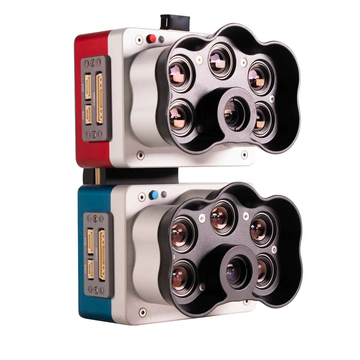
MicaSense RedEdge-P Dual: 10-Band Multispectral Payload for Vegetation Analysis and Environmental Mapping on the SkyScout Series
The MicaSense RedEdge-P Dual is a professional-grade dual multispectral and RGB composite sensor payload designed for drone-based vegetation analysis, environmental monitoring, and precision agriculture. Built by AgEagle in the USA, it combines the RedEdge-P and RedEdge-P Blue cameras into a single integrated system that captures 10 spectral bands simultaneously, producing imagery comparable to Landsat 8 and Sentinel 2A satellite data at significantly higher resolution.
Compatible with the WISPR SkyScout Series, it gives field operators the spectral depth needed for plant classification, weed identification, water body analysis, and multi-temporal research workflows.
The dual sensor configuration captures 1.6 MP per multispectral band at a ground sample distance of 7.7 cm / 3 in per pixel at 120 m / 400 ft AGL, with a 5.1 MP panchromatic band achieving 3.98 cm / 1.5 in per pixel at the same altitude. Pan-sharpening technology pushes spatial resolution to 2 cm / 0.8 in per pixel for detailed output.
A global shutter across all 10 lenses eliminates distortion during flight, while double radiometric calibration via the included DLS2 light sensor and CRP2 reflectance panel ensures consistent, reliable data across varying light conditions. Synchronized 10-band capture with automatic triggering and geotagging streamlines both flight operations and post-processing workflows.
MicaSense RedEdge-P Dual Core Features and Advantages
- 10-band multispectral capture: two sensors collect coastal blue through near-IR data simultaneously.
- Coastal blue band: dedicated wavelength supports shallow water vegetation and weed analysis.
- Pan-sharpening technology: produces spatial resolution of 2 cm / 0.8 in per pixel output.
- Global shutter: all 10 lenses capture distortion-free imagery for accurate data collection.
- Double radiometric calibration: DLS2 and CRP2 panel deliver reliable data in varied light.
- 5.1 MP panchromatic band: 3.98 cm / 1.5 in GSD at 120 m supports high-detail mapping.
- Synchronized capture: all 10 bands trigger simultaneously with automatic image geotagging.
- Fast capture rate: up to 3 raw DNG images per second for efficient area coverage.
- Multiple index outputs: generates RGB, NDVI, NDRE, OSAVI, NIT, CIR, and DSM data products.
- American made: designed and built in the USA by AgEagle for professional field deployment.
The MicaSense RedEdge-P Dual solves a core problem in advanced aerial data collection: producing satellite-comparable multispectral datasets from a drone platform without sacrificing spatial resolution or radiometric accuracy.
Its 10-band configuration, double calibration system, and synchronized geotagged capture give operators a dependable pipeline from flight to deliverable across agriculture, environmental research, habitat monitoring, and water resource management missions.
DSLRPros carries the full MicaSense RedEdge-P Dual kit for the WISPR SkyScout Series, including the RedEdge-P and RedEdge-P Blue sensors, DLS2 light sensor, CRP2 reflectance panel, and all supporting hardware.
Whether you are building a new multispectral program or upgrading an existing RedEdge-P setup, our team can help you configure the right option. Order the MicaSense RedEdge-P Dual at DSLRPros today.
