Skip to product information
1 of 1

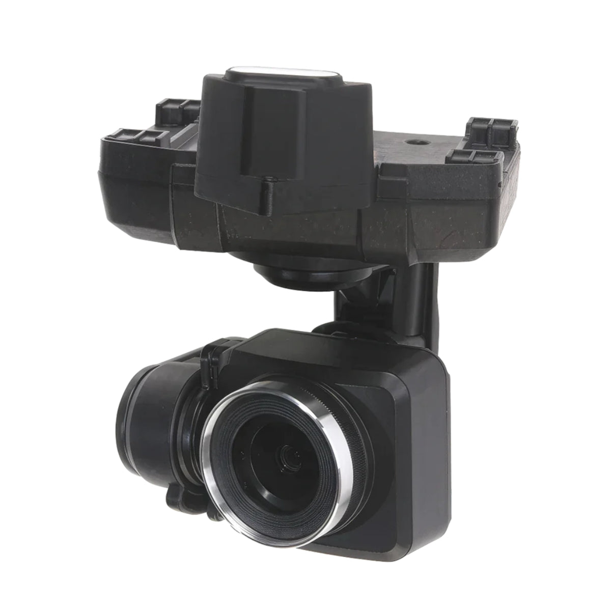
ACSL SOTEN Multispectral Camera

ACSL SOTEN Multispectral Camera

Regular price $5,405.00
Regular price Sale price $5,405.00
Sale Sold out
Shipping calculated at checkout.

SKU:S-SOTEN-CX-GB300

SKU S-SOTEN-CX-GB300 MPN CX-GB300
  • 20 MP 1-inch sensor captures high-detail multispectral imagery per frame
  • RGB TIFF 16-bit output delivers maximum spectral data depth and fidelity
  • Triple bandpass filter isolates spectral bands for NDVI vegetation analysis
  • Solar sensor corrects for ambient light variation during survey flights
  • Three-axis gimbal stabilizes to ±0.02° across pan, tilt, and roll
  • RTK module compatible for centimeter-level geotagged multispectral deliverables
  • EXIF output integrates with photogrammetry and spectral analysis software pipelines
  • One-touch swappable mount attaches without tools on the SOTEN airframe
  • Supports up to 512GB microSD on U3 or V30 rated cards
  • Compatible with both TENSO and TAITEN SOTEN Smart Controllers
View full details
  • Description
  • Specifications
  • In the Box
  • FAQ

ACSL SOTEN Multispectral Camera: 20 MP RGB TIFF Multispectral Payload for Vegetation Analysis on the SOTEN Platform

The ACSL SOTEN Multispectral Camera is a 20 MP gimbal payload built exclusively for the ACSL SOTEN unmanned aircraft system, designed for agricultural, environmental, and land management missions that require spectral data beyond what standard RGB cameras can capture.

Manufactured by Xacti Corporation in Japan, it captures RGB TIFF 16-bit imagery through a field-attachable triple bandpass filter and includes a solar sensor for ambient light correction, producing the calibrated multispectral data that vegetation index analysis and crop health monitoring workflows depend on.

It attaches and detaches via the SOTEN's one-touch swappable camera bay without tools, with the gimbal initializing automatically on power-up.

Key Features and Benefits

  • Sensor resolution: 20 MP 1-inch sensor captures high-detail multispectral imagery per frame
  • Image format: outputs RGB TIFF 16-bit files for maximum spectral data depth and fidelity
  • Triple bandpass filter: field-attachable filter isolates spectral bands for vegetation index analysis
  • Solar sensor: built-in ambient light sensor corrects for variable lighting conditions during capture
  • Gimbal stabilization: 3-axis stabilization maintains ±0.02° accuracy across pan, tilt, and roll
  • Focal length: 28 mm equivalent with H64°, V44°, D73° FOV for consistent area coverage per pass
  • Dual shutter modes: mechanical and electronic shutters cover both precision and high-speed capture
  • RTK compatibility: EXIF data integrates with RTK module for geotagged multispectral deliverables
  • One-touch swap: attaches and detaches without tools; gimbal self-initializes on power-up
  • microSD recording: supports up to 512GB on U3 or V30 rated cards in FAT32 or exFAT format

For operators running precision agriculture programs, environmental monitoring surveys, or land management assessments, the Multispectral Camera converts the SOTEN into a dedicated spectral imaging platform without requiring a separate aircraft.

Its 1-inch sensor, 28 mm equivalent focal length, and EXIF output compatible with RTK and mapping software make it practical for both standalone spectral surveys and integrated workflows combining multispectral capture with positional accuracy from the SOTEN RTK module.

The same airframe that runs inspection and documentation missions during the week becomes an agriculture data collection platform when this payload is installed.

Spectral Data That Drives Agronomic Decisions

Effective vegetation analysis requires imagery that separates what the eye cannot — stressed crops from healthy ones, irrigated zones from drought-affected areas, early disease onset from normal growth variation.

The ACSL SOTEN Multispectral Camera's triple bandpass filter isolates the spectral bands used in NDVI and other vegetation index calculations, and the solar sensor corrects for the ambient light variation that would otherwise introduce inconsistency across a survey flight.

At 20 MP on a 1-inch sensor with RGB TIFF 16-bit output, it captures the data depth that agronomic software needs for reliable index mapping across fields of any size. RTK module integration adds centimeter-level geotagging to each frame, so the resulting maps carry the spatial accuracy needed for variable-rate application planning, irrigation management, and yield assessment without requiring additional ground control points or post-flight correction passes.

Compatibility and System Integration

  • ACSL SOTEN: exclusive compatible aircraft via one-touch swappable camera bay interface
  • ACSL TAKEOFF: fully integrated ground control application for mission planning and camera triggering
  • ACSL TENSO Smart Controller: compatible for standard operational range and agriculture survey flights
  • ACSL TAITEN Smart Controller: compatible with extended range and full gimbal control customization
  • ACSL SOTEN RTK Module: integrates for centimeter-level geotagging of multispectral imagery per frame
  • RTK and mapping software: EXIF output compatible with photogrammetry and spectral analysis pipelines
  • microSD storage: U3 or V30 minimum, up to 512GB; FAT32 and exFAT file systems supported

Applications and Use Cases

  • Crop health monitoring: NDVI and vegetation index mapping identifies stress, disease, and deficiency zones
  • Irrigation management: spectral variance across fields pinpoints water stress and distribution inefficiencies
  • Precision agriculture planning: multispectral maps inform variable-rate fertilization and application decisions
  • Environmental monitoring: vegetation coverage and land condition assessments for land management programs
  • Reforestation surveys: spectral data tracks canopy health and regrowth progress across replanted areas
  • Research and academic fieldwork: 16-bit TIFF output supports scientific spectral analysis and data archiving
  • Weed and pest detection: early spectral anomalies identify infestation zones before visible damage appears

The ACSL SOTEN Multispectral Camera turns the SOTEN platform into a precision spectral imaging tool without requiring a dedicated agriculture aircraft. Its triple bandpass filter, solar sensor, and 16-bit TIFF output deliver the calibrated multispectral data that crop health monitoring, vegetation analysis, and land management programs depend on—from a payload that swaps in and out of the same airframe used for inspection and documentation.

DSLRPros is an authorized U.S. dealer for the full ACSL SOTEN payload lineup. Our team can help you configure the right combination of payloads and accessories, including the RTK module, for your agriculture or environmental monitoring program.

Order the ACSL SOTEN Multispectral Camera at DSLRPros today.

General

  • Model Name: CX-GB300
  • Dimensions: 78 × 99 × 93 mm (W × H × D)
  • Weight: 200 g
  • Dust and Waterproof Rating: IP4X (JIS C 0920)
  • Supply Voltage: 12 V
  • Power Consumption: 12 W (maximum)
  • Operating Temperature: 0°C to 40°C
  • Operating Humidity: 10% to 90%

Camera

  • Image Sensor: 1-inch sensor, 20 MP effective pixels
  • Lens Field of View: 64° (horizontal), 44° (vertical), 73° (diagonal)
  • Focal Length (35 mm equivalent): 28 mm
  • Aperture Range: f/2.8 to f/11
  • Shutter Speed: Mechanical 8–1/2000 s; Electronic 8–1/8000 s
  • ISO Range: Auto, ISO 125–6400
  • Still Image Size: TIFF 2720 × 1814 (5 MP)
  • Photo Format: RGB TIFF 16-bit
  • Live View Format / Quality: MJPEG Full HD @20p
  • Supported File Systems: FAT32, exFAT

Storage

  • Supported SD Cards: microSD (UHS Speed Class U3, Video Speed Class V30 or above), up to 512 GB
  • Recommended SD Cards: SanDisk Extreme 32 GB (SDSQXAF-032G-JN3MD); 64 GB (SDSQXAF-064G-JN3MD); 128 GB (SDSQXA0-128G-JN3MD); 256 GB (SDSQXA0-256G-JN3MD); 512 GB (SDSQXA1-512G-GN6MN)

Gimbal

  • Stabilization: 3-axis (pan, tilt, roll)
  • Minimum Control Accuracy: ±0.02°
  • Mechanical Range: Pan ±90°; Tilt −120° to +50°; Roll ±30°
  • Controllable Range: Pan ±85°; Tilt −115° to +45°
  • Maximum Control Speed: Pan 60°/s; Tilt/Roll 100°/s
  • 1x ACSL SOTEN Multispectral Camera
What is the ACSL SOTEN Multispectral Camera and what is it used for?

The ACSL SOTEN Multispectral Camera is a 20 MP, 1-inch sensor gimbal payload manufactured by Xacti Corporation in Japan, designed exclusively for the ACSL SOTEN unmanned aircraft system. It captures RGB TIFF 16-bit imagery through a triple bandpass filter and includes a solar sensor for ambient light correction, making it suited for crop health monitoring, vegetation index analysis, environmental surveys, and precision agriculture data collection. It mounts via the SOTEN's one-touch swappable camera bay and is not compatible with other aircraft.

What is a triple bandpass filter and why does it matter for multispectral imaging?

A triple bandpass filter restricts the wavelengths of light that reach the camera sensor to specific spectral bands used in vegetation analysis — typically covering ranges associated with visible red, green, and near-infrared light. By isolating these bands, the filter enables the camera to capture data that standard RGB sensors cannot distinguish, forming the basis for vegetation index calculations such as NDVI that quantify crop health, stress, and coverage. The filter on the ACSL SOTEN Multispectral Camera is field-attachable and twists on and off without tools.

What role does the solar sensor play in multispectral data collection?

The solar sensor measures ambient light conditions during the flight and provides irradiance data used to normalize the multispectral imagery captured by the camera. This correction is important because variations in sunlight intensity and angle between flight passes — caused by cloud cover, time of day, or flight path changes — can introduce inconsistencies in spectral reflectance values that affect index calculations. Including solar sensor data in post-processing produces more reliable and repeatable vegetation index maps across an entire survey area.

Does the ACSL SOTEN Multispectral Camera work with the RTK module for precision agriculture workflows?

Yes. The ACSL SOTEN RTK Module integrates with the Multispectral Camera to add real-time kinematic positioning, enabling centimeter-level geotagging of each captured TIFF frame. This spatial accuracy is important for precision agriculture workflows where multispectral maps need to align with field management zones, irrigation infrastructure, and variable-rate application boundaries. The RTK module is available as a standalone accessory at DSLRPros or is included in the Survey RTK Bundle Plus configurations.

Can the ACSL SOTEN Multispectral Camera be used on the same aircraft that runs inspection missions?

Yes. Because the Multispectral Camera uses the same one-touch swappable bay as all other SOTEN payloads, operators can install it on any SOTEN aircraft currently used for inspection or documentation work. No airframe modification or recalibration is required. A single aircraft can run powerline inspection with the Standard Camera in the morning and switch to multispectral agriculture survey with this payload in the afternoon, with the swap completed in the field without tools.

What file format does the ACSL SOTEN Multispectral Camera output and why is 16-bit TIFF significant?

The camera outputs RGB TIFF files at 16-bit color depth, producing images at 2720 x 1814 pixels (5 MP). A 16-bit TIFF preserves a much wider range of tonal and spectral values than an 8-bit JPEG, which is important for vegetation index calculations that depend on precise reflectance differences between spectral bands. The format is directly compatible with agronomic and scientific software that processes multispectral data for NDVI mapping, stress analysis, and research applications.