


Drone Trends
View all-

DSLRPros Announces Partnership with WISPR Systems to Deliver American-Made Bl...
Partnership Expands Access to Blue UAS-Listed and NDAA-Compliant Drone Technology DSLRPros is pleased to announce a new partnership with WISPR Systems, a U.S.-based manufacturer of American-made drone solutions for professional and mission-critical operations. Through this partnership, DSLRPros customers can now access WISPR's portfolio of Blue UAS-listed and NDAA-compliant drone technologies, including the SkyScout 2 platform and supporting payload solutions for...
-

Autonomous Drone Operations with FlytBase and DJI Dock 3: From Drone Deployme...
Enterprise drone programs are entering a new phase. For years, drones have helped organizations capture aerial images, inspect assets, map job sites, respond to emergencies, and improve situational awareness. But most drone operations have still depended on manual launch, manual piloting, manual scheduling, and manual data collection. That model works for occasional missions. It does not scale easily for organizations...
-

DJI Firmware Support Through 2029: What the FCC Extension Means
Existing DJI fleets can continue receiving qualifying firmware and software updates through at least January 1, 2029. Here’s what the FCC DJI firmware extension actually means for enterprise and public safety drone operations. Public safety agencies and enterprise drone teams have spent the past year asking the same question: Will existing DJI drones continue receiving firmware support long term? The...


Drones to the Rescue
View all-
GDU S220 Pro Drones: Complete Guide to Industrial AI and Performance
Introducing the GDU S220 Pro Series from DSLRPros DSLRPros expands its enterprise drone portfolio with the launch of the GDU S220 Pro Series—a compact, modular UAV platform built for demanding field operations. Developed by GDU-Tech Co., Ltd., the S220 Pro combines precision engineering, advanced imaging, and modular versatility to meet the needs of inspection, search and rescue, and public safety...
-
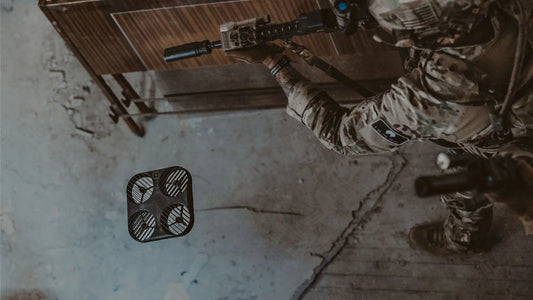
DSLRPros Expands Portfolio with DarkHive Tactical Systems
DSLRPros now offers DarkHive products, giving defense, law enforcement, and public safety agencies access to American-made drones and training solutions designed for tactical use. As U.S. agencies reduce reliance on foreign-manufactured platforms, the need for secure, rapidly deployable, and cost-effective systems has become a priority. Founded in Texas in 2021, DarkHive develops small unmanned aircraft systems (sUAS) optimized for Size,...
-
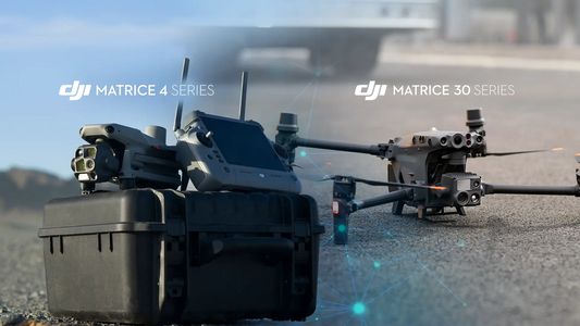
Upgrading to DJI Matrice 4 from Matrice 30 – Smart Move or Overkill?
You’ve seen the headlines. The Matrice 4 is DJI’s latest heavyweight for enterprise ops. And it’s already tempting teams to retire their Matrice 30s. But does it actually deliver meaningful gains in the field, or is it just a shinier payload hauler? This isn’t a hype reel. It’s a side-by-side breakdown designed for professionals who rely on drones to make...


Learning Center
View all-

How to Update Drone Firmware for DJI, Autel, ACSL SOTEN, and Inspired Flight
Updating drone firmware is one of the simplest ways to keep your aircraft stable, safe, and compliant. Most mission issues—GPS drift, sensor errors, flight-control bugs—come from outdated firmware. And for public safety, inspection, and industrial teams, a missed update can slow operations or create avoidable risk. This guide shows how to update firmware across DJI, Autel, ACSL SOTEN, and Inspired...
-

Understanding Drone Flight Path Planning Software: A Complete Guide for Profe...
If you're still manually flying missions or relying on guesswork to cover an area, you're not just wasting time—you could be compromising safety, compliance, and data quality. For professionals in industries like public safety, energy, agriculture, or surveying, drone flight path planning software has become an operational must-have. This guide unpacks what flight planning software is, what it does, and how...
-

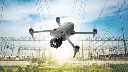
How Thermal Drones Prevent Industrial Accidents
Industrial worksites are complex, high-risk environments. From faulty transformers to flammable gas leaks, even a minor oversight can escalate into injury, equipment loss, or fatality. Traditional safety inspections are often slow, reactive, and risky for human inspectors. Thermal drones change the game. With infrared sensors, gas detectors, and high-resolution optics, these aerial systems detect early signs of danger before they...


Blog Categories
-

Drone to the Rescue
ExploreExplore how drones are saving lives and solving real-world problems, from search-and-rescue missions to disaster relief operations.
-

Learning Center
ExploreYour go-to hub for drone knowledge! Learn tips, tricks, and best practices to master your drone skills.
-

Enterprise Products
ExploreDiscover advanced drones and tools tailored for businesses, public safety, and industrial applications.
-

Drone Trends
ExploreStay ahead with the latest drone innovations, industry news, and emerging technologies shaping the future.


