


WISPR SkyScout 2 with Black Herelink
WISPR SkyScout 2 with Black Herelink
SKU:S-WSP-SS2-BLK-HLK

- Description
- Specifications
- In the Box
- FAQ
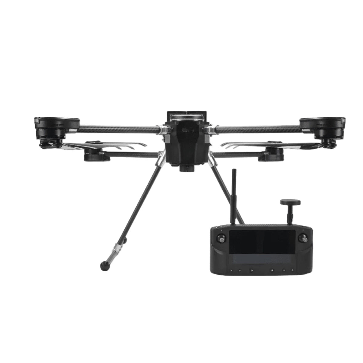
WISPR SkyScout 2 with Herelink Black Controller: American-Made Precision for Survey-Grade Mission Execution
The WISPR SkyScout 2 is a compact, foldable quadcopter designed and manufactured in the United States for professionals who need reliable aerial data collection in demanding field conditions. Built around a Cube Orange+ flight controller running custom WISPR firmware, the SkyScout 2 supports RTK and PPK geotagging, carries payloads up to 3.85 lbs., and withstands winds up to 50 MPH, making it a capable platform for mapping, inspection, public safety, and utility workflows.
Key Features and Benefits
- Blue UAS and NDAA compliance: Blue UAS approved and NDAA Section 848 compliant for government, defense, and critical infrastructure procurement.
- RTK geotagging: real-time sub-centimeter positioning via NTRIP or RTCM services included standard.
- Hot-swap batteries: field-swappable 4350mAh packs charge in 45 minutes and support mission resume.
- Payload capacity: carries up to 3.85 lbs. for versatile sensor and camera configurations in the field.
- Wind resistance: 50 MPH max wind rating sustains stable flight in challenging outdoor conditions.
- Collision avoidance: LiDAR TOF sensors cover front, rear, and downward directions up to 164 ft.
- TempGuard system: active and passive thermal management maintains performance across temperature extremes.
- SignalShield protection: advanced EMI shielding reduces interference near power lines and cell towers.
- TerrainSense follow: GNSS or LiDAR-based terrain following supports reliable low-altitude guidance.
- Foldable airframe: folded dimensions of 4.5" x 10" x 17" fit inside a carry-on sized hard case.
This bundle pairs the SkyScout 2 with the Herelink Black controller, a compact and advanced remote control system featuring a 5.5-inch LCD screen rated at 1000 nits for clear outdoor visibility. The Herelink Black transmits 1080p video at 30fps over a secure 2.4GHz LTE connection at up to 12 miles, with dual antennas and AES128 encryption ensuring stable, secure communication across professional field operations. Together, the SkyScout 2 and Herelink Black deliver a mission-ready, NDAA-compliant system for operators who demand dependable tools in the field.
When the Job Demands Accuracy and the Site Demands Speed
When a survey crew needs centimeter-level data from a platform that fits in carry-on luggage and deploys before the rest of the gear is unpacked, the SkyScout 2 is the answer. Its operating temperature range of -4°F to 122°F, combined with TempGuard climate management and SignalShield EMI protection, means the platform holds up in industrial environments, near high-voltage infrastructure, and across seasonal extremes.
The SmartCore power distribution system monitors both batteries simultaneously and provides redundant protection, while the onboard Battery Management System delivers predictive maintenance alerts and real-time health data before issues affect your mission. For operators running survey, inspection, or public safety workflows, consistent data quality and platform reliability directly translate to fewer repeat flights and lower operational cost over time.
Compatibility and System Integration
- Cube Orange+ flight controller: runs WISPR Flight Firmware on an ArduPilot and PX4 compatible platform (included).
- Herelink Black controller: integrated RC control, 1080p video transmission, and telemetry in a single NDAA-compliant unit (included).
- WISPR Smart Batteries: two 4350mAh hot-swappable LiPo packs with full BMS protection (included, 1 pair).
- WISPR 110V battery charger: field-ready charging solution for WISPR Smart Batteries (included).
- WISPR Ground Control: mission planning software with payload-specific speed and parameter profiles (included).
- WISPR Cloud: required for PPK subscription and cloud-based mission data management (sold separately).
- Gremsy Vio and Zio gimbals: compatible via S-Port quick-attach system with no wiring required (sold separately).
- RESEPI and YellowScan LiDAR systems: natively supported within WISPR Ground Control payload profiles (sold separately).
- GeoCue TrueView and T1 LiDAR: supported payload options within WISPR Ground Control (sold separately).
- ILX-LR1 and WISPR 24MP Mapper cameras: supported RGB mapping payloads for photogrammetry workflows (sold separately).
Applications and Use Cases
- Licensed surveyors: deliver centimeter-accurate geotags via RTK or PPK without a ground control point grid.
- Public safety commanders: airborne in under three minutes with pre-configured Remote ID and no setup delays when the call comes in.
- DoD and federal procurement: fully Blue UAS approved and NDAA Section 848 compliant for government fleet acquisition.
- Infrastructure inspection teams: compact folded profile and 50 MPH wind rating keep crews on schedule at towers, corridors, and substations.
- LiDAR operators: dedicated starboard GNSS antenna mount captures raw GNSS data for point cloud accuracy across supported LiDAR payloads.
- Agricultural service providers: 3.85 lb. payload capacity supports multispectral and thermal sensors across large area coverage missions.
- Rapid deployment teams: hot-swappable batteries and carry-on sized case mean the system is mission-ready within minutes of arriving on site.
The SkyScout 2 is built for operators who need a compact, domestically produced platform that performs consistently across a wide range of mission types. Its combination of RTK/PPK precision, a 3.85 lb. payload capacity, and proven collision avoidance makes it a dependable tool for professional data collection in environments where accuracy and reliability are not optional.
DSLRPros has decades of experience supporting UAS professionals across public safety, inspection, mapping, and enterprise workflows. When you purchase the WISPR SkyScout 2 with Herelink Black through DSLRPros, you get the platform backed by a team that understands how it fits into your operation.
Order today at DSLRPros and put a purpose-built American drone to work on your next mission.
