


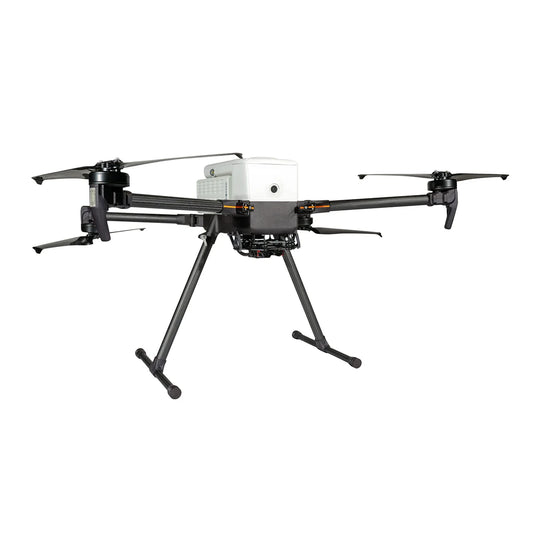
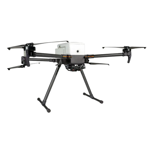


Inspired Flight IF800 Tomcat: USA-Made Quadcopter for Survey, Inspection, and LiDAR Operations
The Inspired Flight IF800 Tomcat is a medium-lift quadcopter engineered, assembled, and supported in the United States, built for professional operators who run demanding missions where endurance, payload capacity, and procurement compliance all matter.
With a maximum flight time of 54 minutes, a 6.6 lb (3.0 kg) payload capacity, and a top air speed of 49 mph (22 m/s), the IF800 Tomcat handles survey corridors, multi-pass LiDAR runs, infrastructure inspection routes, and agriculture data collection missions that lighter aircraft cannot sustain. It is NDAA-compliant, Blue UAS certified, and Green UAS certified—cleared for government, defense, and enterprise procurement programs that require sourcing accountability.
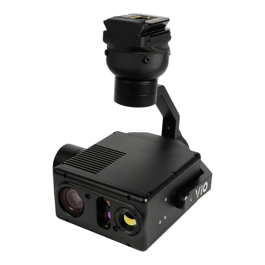
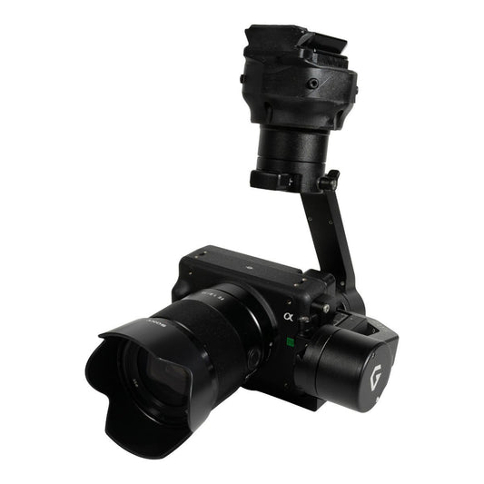
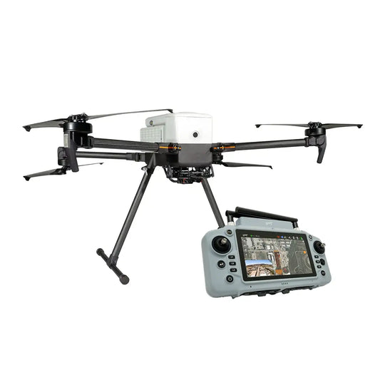
At DSLRPros, the IF800 Tomcat is available in complete bundles with your choice of the GS-ONE or Blue Herelink ground control station, as well as payload-specific configurations pairing the airframe with the Gremsy VIO, Sony ILX-LR1, Sentera 65R, Sentera 6X Thermal Pro, MicaSense Altum-PT, or GeoCue TrueView 1 Lite LiDAR. Accessories: battery kits, spare propeller sets, spare part kits, and integration hardware, are stocked and available to ship with your order. DSLRPros carries everything the IF800 Tomcat needs to get into the field and stay there.
Inspired Flight IF800 Tomcat: Bundle and Configuration Options at DSLRPros
- IF800 Tomcat with GS-ONE Ground Control Station: aircraft plus 7-inch 2,000-nit GCS, NDAA and Blue UAS compliant controller with 5-hour runtime and hot-swappable battery
- IF800 Tomcat with Blue Herelink GCS: aircraft plus 5.46-inch Herelink controller with 1,000-nit brightness, built-in 4,950 mAh battery, and approximately 4-hour runtime
- IF800 Tomcat with Blue Herelink + Gremsy VIO Bundle: aircraft, Blue Herelink GCS, and Gremsy VIO stabilized gimbal payload — contact DSLRPros for pricing
- IF800 Tomcat with Blue Herelink + Sony ILX-LR1 Bundle: aircraft, Blue Herelink GCS, and Sony ILX-LR1 high-resolution camera payload — contact DSLRPros for pricing
IF800 Tomcat Flight Performance and Technical Specifications
The IF800 Tomcat's performance envelope is built around a CubePilot Cube Blue H7 flight controller with triple redundant IMU and dual CubePilot Here4 GNSS modules, running ArduPilot Copter QUAD V. The result is a flight stack with the positioning reliability and autonomous mission capability that professional survey and inspection programs require.
Maximum flight time is 54 minutes, maximum airspeed is 49 mph (22 m/s), and wind resistance holds up to 23-knot gusts (12 m/s). The aircraft climbs at up to 16 ft/s (5 m/s) and descends at up to 10 ft/s (3 m/s), with a maximum tilt angle of 30° and an operating temperature range of -4°F to +113°F (-20°C to +45°C).
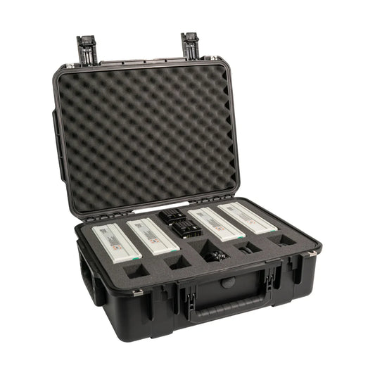
The airframe folds to 14.2 x 17.4 x 7.8 inches (36 x 44 x 20 cm) for transport in the included purpose-built case, and opens to 51.8 x 44.8 x 20.3 inches (132 x 114 x 52 cm) for flight. Empty weight without batteries is 9.2 lbs (4.2 kg); with both IB388 batteries installed, total weight is 18.7 lbs (8.5 kg).
Maximum gross takeoff weight is 25.3 lbs (11.5 kg) against a maximum payload capacity of 6.6 lbs (3.0 kg). Service ceiling scales with payload: 14,000 ft (4.2 km) unloaded, 10,500 ft (3.2 km) with 3.3 lbs (1.5 kg), and 6,500 ft (2.0 km) at maximum 6.6 lb (3.0 kg) payload. The LightWare SF000/B downward ground sensor is standard. Payload interface is Pixhawk Payload Bus Standard with 12V at 2A power rails.
IF800 Tomcat Payload Compatibility, Accessories, and Ground Control Hardware
The table below compares the six field-swappable payloads available for the IF800 Tomcat at DSLRPros, covering sensor type, primary mission fit, and integration notes.
| Payload | Type Sensor Category | Primary Mission Best For | Key Spec Headline Figure | Integration Notes |
|---|---|---|---|---|
| Sony ILX-LR1 | High-resolution optical | Mapping, documentation, research | 61 MP full-frame mirrorless sensor | Mounts directly to IF800 airframe |
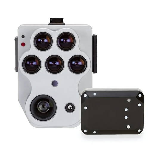
| Gremsy VIO | Stabilized gimbal | Inspection, video documentation | 3-axis stabilized gimbal system | Supports multiple camera configurations |
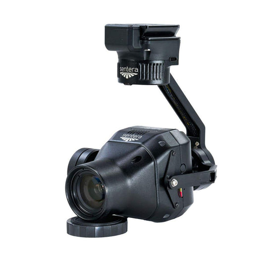
| Sentera 65R | Multispectral / RGB | Agriculture, survey, environmental | High-resolution RGB and multispectral | Also compatible with IF1200 |
| Sentera 6X Thermal Pro | Thermal | Inspection, public safety | 6X thermal sensor kit for IF800 | IF800-specific kit configuration |
| MicaSense Altum-PT | Multispectral | Precision agriculture, research | Panchromatic + 5-band multispectral | Requires IF800 integration kit |
| GeoCue TrueView 1 Lite | LiDAR | Terrain modeling, 3D mapping | LiDAR point cloud generation | Requires LiDAR integration kit |
Scroll horizontally to view all payload details.
The table below compares the two ground control station options available for the IF800 Tomcat.
| Specification | Option 1 GS-ONE | Option 2 Blue Herelink |
|---|---|---|
| Display size | 7 inches | 5.46 inches |
| Brightness | 2,000 nits (sunlight-readable) | 1,000 nits |
| Battery | Hot-swappable battery system | Built-in 4,950 mAh Li-ion |
| Runtime | Up to 5 hours | Approximately 4 hours |
| Controls | Standard layout | Customizable buttons and control wheel |
| NDAA compliant | Yes | Yes (Blue Herelink variant) |
| Blue UAS certified | Yes | Yes (Blue Herelink variant) |
| Best for | High-ambient-light ops, extended field days | Compact setup, customizable control layout |
Both GCS options are available as part of complete IF800 Tomcat bundles at DSLRPros.
Accessories and maintenance hardware:
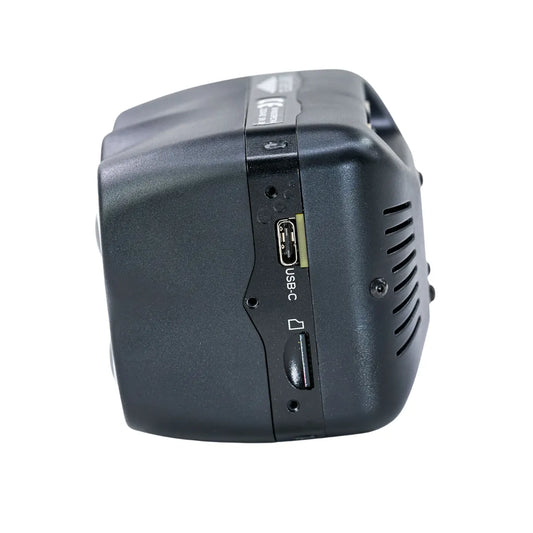
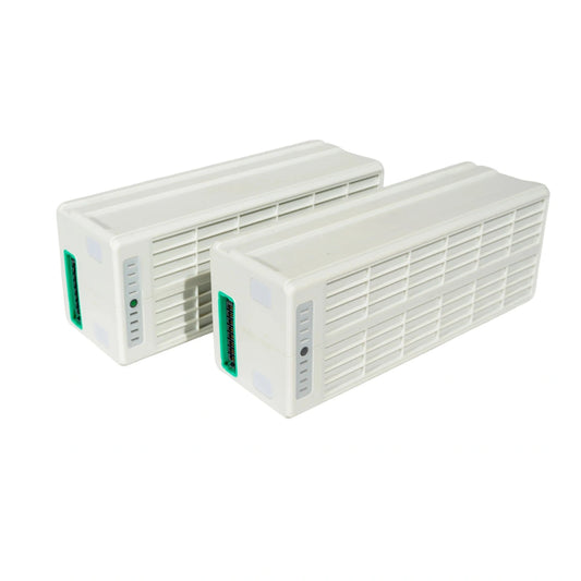
- IF800 Battery Kit: multiple IB388 batteries and accessories configured for extended multi-sortie operations
- IF800 Battery Set: spare IB388 LiHv batteries, each rated at 387.6 Wh and 17,000 mAh for full-endurance flights
- IF800 Spare Propeller Set: two CW and two CCW folding propellers with replacement screws; Loctite required, not included
- IF800 Spare Part Kit: landing gear, screws, and essential components for field maintenance and on-site repairs
- Inspired Flight Universal MicaSense Integration Kit: mounting hardware for MicaSense payload integration on IF800
- Inspired Flight LiDAR Integration Kit: hardware for integrating the GeoCue TrueView 1 Lite on the IF800 airframe
What the IF800 Tomcat Delivers Across Professional Field Operations
- Flight endurance: 54-minute maximum flight time extends survey coverage and inspection corridor length per sortie
- Payload capacity: 6.6 lb (3.0 kg) maximum accommodates LiDAR, multispectral, thermal, and high-resolution gimbal payloads
- Hot-swap batteries: dual IB388 LiHv batteries slide in and out without powering down the aircraft between sorties
- Flight controller: CubePilot Cube Blue H7 with triple redundant IMU provides reliability for autonomous mission execution
- GNSS redundancy: dual CubePilot Here4 modules maintain positioning accuracy across all flight modes and mission profiles
- Compliance credentials: NDAA-compliant, Blue UAS certified, and Green UAS certified for government and enterprise procurement
- Foldable frame: collapses to 14.2 x 17.4 x 7.8 inches (36 x 44 x 20 cm) for transport in the purpose-built aircraft case
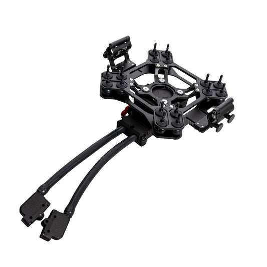
- Adjustable payload rail: center-of-gravity adjustment keeps flight characteristics consistent across different payload weights
- RTK/PPK ready: dedicated mounting points for GNSS antennas and RTK/PPK modules support precision geotagging workflows
- Upward shooting: 30° upward-angle shooting capability captures data from perspectives beyond standard nadir-only operations
- FPV camera: onboard first-person view camera provides real-time visual feedback during all flight operations
- USA-made: engineered, assembled, and supported in the United States with a dedicated domestic support team
Where the IF800 Tomcat Gets Deployed: Field Applications
- Aerial mapping and photogrammetry: 54-minute endurance and RTK/PPK mounting support cover large survey areas per sortie
- LiDAR terrain modeling: 6.6 lb payload capacity accommodates the GeoCue TrueView 1 Lite for full 3D point cloud output
- Infrastructure inspection: powerlines, bridges, towers, and pipelines documented with thermal or high-resolution optical payloads
- Precision agriculture: Sentera 65R and MicaSense Altum-PT deliver NDVI, multispectral, and crop health data at field scale
- Search and rescue: extended flight time and FPV camera support personnel location across large or complex terrain
- Construction monitoring: high-resolution imagery and LiDAR data track progress and validate as-built site conditions
- Environmental monitoring: multispectral sensor payloads document vegetation health, land cover, and ecosystem changes over time
- Airport pavement inspection: high-resolution RGB imagery with the Sentera 65R supports runway condition documentation programs
ArduPilot, Pixhawk Payload Bus, and IF800 Tomcat Workflow Integration
The IF800 Tomcat runs ArduPilot Copter QUAD V, giving operators access to the full ArduPilot autonomous mission planning ecosystem. Six flight modes cover the range from precise slow-speed inspection passes in Loiter mode to pre-programmed waypoint corridor missions in Auto mode, with Position Hold for responsive maneuvering, RTL for automatic return-and-land, Land for autonomous touchdown, and Altitude Hold as a GPS-loss failsafe.
The Pixhawk Payload Bus Standard interface handles payload power and data communication at 12V and 2A, supporting integration with a broad range of third-party sensors without custom electrical work. RTK and PPK workflows are supported through dedicated mounting points for GNSS antennas, keeping survey-grade geotagging clean and consistent across all compatible payloads.
Both the GS-ONE and Blue Herelink GCS options integrate directly with the airframe's control architecture, with the GS-ONE adding hot-swappable controller batteries and a 2,000-nit display suited to direct sunlight operations, and the Herelink offering a compact, customizable controller format for operators who prefer a lighter ground station.
Choosing the Right IF800 Tomcat Configuration for Your Mission
- GCS selection: choose the GS-ONE for high-ambient-light environments and extended controller battery endurance; choose the Blue Herelink for a more compact controller with customizable button layout
- Payload selection: match the payload to the mission discipline—Sony ILX-LR1 or Gremsy VIO for inspection and documentation, Sentera 65R or MicaSense Altum-PT for agriculture, GeoCue TrueView 1 Lite for LiDAR, Sentera 6X Thermal Pro for thermal inspection and public safety
- Altitude planning: account for payload weight when planning high-altitude missions—service ceiling drops from 14,000 ft with no payload to 6,500 ft at maximum 6.6 lb payload
- Battery configuration: the IF800 Battery Kit covers extended multi-sortie operations; the IF800 Battery Set adds individual spare IB388 units to an existing kit
- Integration hardware: the LiDAR Integration Kit is required for GeoCue TrueView 1 Lite installation; the Universal MicaSense Integration Kit covers MicaSense Altum-PT mounting
- Procurement compliance: NDAA compliance, Blue UAS certification, and Green UAS certification are confirmed — documentation is available through DSLRPros for government and enterprise acquisition workflows
The IF800 Tomcat is built for operators who cannot afford compromises on endurance, payload flexibility, or compliance documentation. Its USA-engineered airframe, redundant flight stack, and open payload interface make it a long-term operational platform across survey, inspection, agriculture, and public safety programs that require consistent, sortie-after-sortie reliability.
DSLRPros is an authorized dealer for the Inspired Flight IF800 Tomcat, stocking the full lineup of aircraft bundles, payloads, and accessories. Our pre-sale team provides configuration guidance to match the right payload and GCS combination to your mission requirements.
Shop the IF800 Tomcat collection at DSLRPros today and contact us to configure your setup.
FAQs
What is the Inspired Flight IF800 Tomcat and who is it designed for?
The Inspired Flight IF800 Tomcat is a medium-lift quadcopter engineered, assembled, and supported in the United States, built for professional operators in survey, inspection, agriculture, LiDAR, and public safety applications. It carries up to 6.6 lbs (3.0 kg) of payload and flies for up to 54 minutes on dual hot-swappable IB388 LiHv batteries. It runs on a CubePilot Cube Blue H7 flight controller with triple redundant IMU, is NDAA-compliant, Blue UAS certified, and Green UAS certified, and is available in complete bundles with compatible payloads and ground control stations at DSLRPros.
What makes the IF800 Tomcat NDAA-compliant and Blue UAS certified?
The IF800 Tomcat is engineered and assembled in the United States using components that meet federal procurement sourcing requirements, placing it on the DoD Blue UAS Cleared List and qualifying it under NDAA restrictions that prohibit the use of drones from covered foreign entities. It is also Green UAS certified. These credentials make it suitable for federal agencies, law enforcement, and enterprise programs operating under procurement compliance requirements. DSLRPros can provide compliance documentation to support government and enterprise acquisition workflows.
What payloads are compatible with the Inspired Flight IF800 Tomcat?
The IF800 Tomcat supports a broad range of field-swappable payloads through its Pixhawk Payload Bus Standard interface with 12V at 2A power rails. Compatible payloads available at DSLRPros include the Sony ILX-LR1 high-resolution camera, Gremsy VIO stabilized gimbal, Sentera 65R multispectral sensor, Sentera 6X Thermal Pro, MicaSense Altum-PT with integration kit, and GeoCue TrueView 1 Lite LiDAR. The adjustable payload rail allows center-of-gravity adjustment to keep flight characteristics consistent across payload configurations, up to the 6.6 lb (3.0 kg) maximum.
What battery does the IF800 Tomcat use and what are the key specs?
The IF800 Tomcat uses two IB388 Lithium Polymer High-Voltage (LiHv) batteries, each rated at 387.6 Wh and 17,000 mAh at a nominal voltage of 22.8V. Each battery weighs 2.08 kg (4.6 lbs) and has an ambient operating temperature range of -10°C to +45°C with a life expectancy of 150 to 300 cycles. Both batteries hot-swap via slide installation without powering down the aircraft. Battery data is accessible over NFC, and aircraft communication runs over DroneCAN.
What are the two ground control station options and how do they differ?
The IF800 Tomcat is available with the GS-ONE or Blue Herelink. The GS-ONE features a 7-inch sunlight-readable touchscreen at 2,000 nits, a hot-swappable battery system, up to 5 hours of runtime, and is Blue UAS and NDAA compliant — suited to operations in direct sunlight and extended field days. The Blue Herelink features a 5.46-inch 1,000-nit touchscreen, a built-in 4,950 mAh Li-ion battery, customizable buttons and a control wheel, and approximately 4 hours of runtime — a compact option for operators who prefer a lighter, configurable controller.
How does payload weight affect the IF800 Tomcat's service ceiling?
The IF800 Tomcat reaches a service ceiling of 14,000 ft (4.2 km) when carrying no payload. With a 3.3 lb (1.5 kg) payload, the ceiling is 10,500 ft (3.2 km), and at the maximum 6.6 lb (3.0 kg) payload, the operational ceiling is 6,500 ft (2.0 km). Operators planning missions in mountainous terrain or at high elevations should factor payload weight into pre-mission planning to confirm the aircraft will reach and maintain the required working altitude throughout the sortie.
What flight modes does the IF800 Tomcat support?
The IF800 Tomcat runs ArduPilot Copter QUAD V and supports six flight modes. Position Hold maintains GPS position and altitude for faster, responsive flying. Loiter holds GPS position and altitude for slow, precise maneuvering suited to close-range inspection. Auto executes pre-defined waypoint missions autonomously. RTL automatically returns the aircraft to its takeoff point and lands. Land performs an autonomous landing while holding horizontal position. Altitude Hold maintains altitude only and serves as a GPS-loss failsafe during operations.
