


ACSL SOTEN Agriculture Bundle Plus with Rapid Deployment Hard Case
ACSL SOTEN Agriculture Bundle Plus with Rapid Deployment Hard Case
SKU:S-SOTEN-RD-MSPEC-BUN-PLUS


- Description
- Specifications
- In the Box
- FAQ
ACSL SOTEN Agriculture Bundle Plus with Rapid Deployment Hard Case: NDAA-Compliant Dual-Camera UAS for Precision Agriculture and Crop Health Monitoring
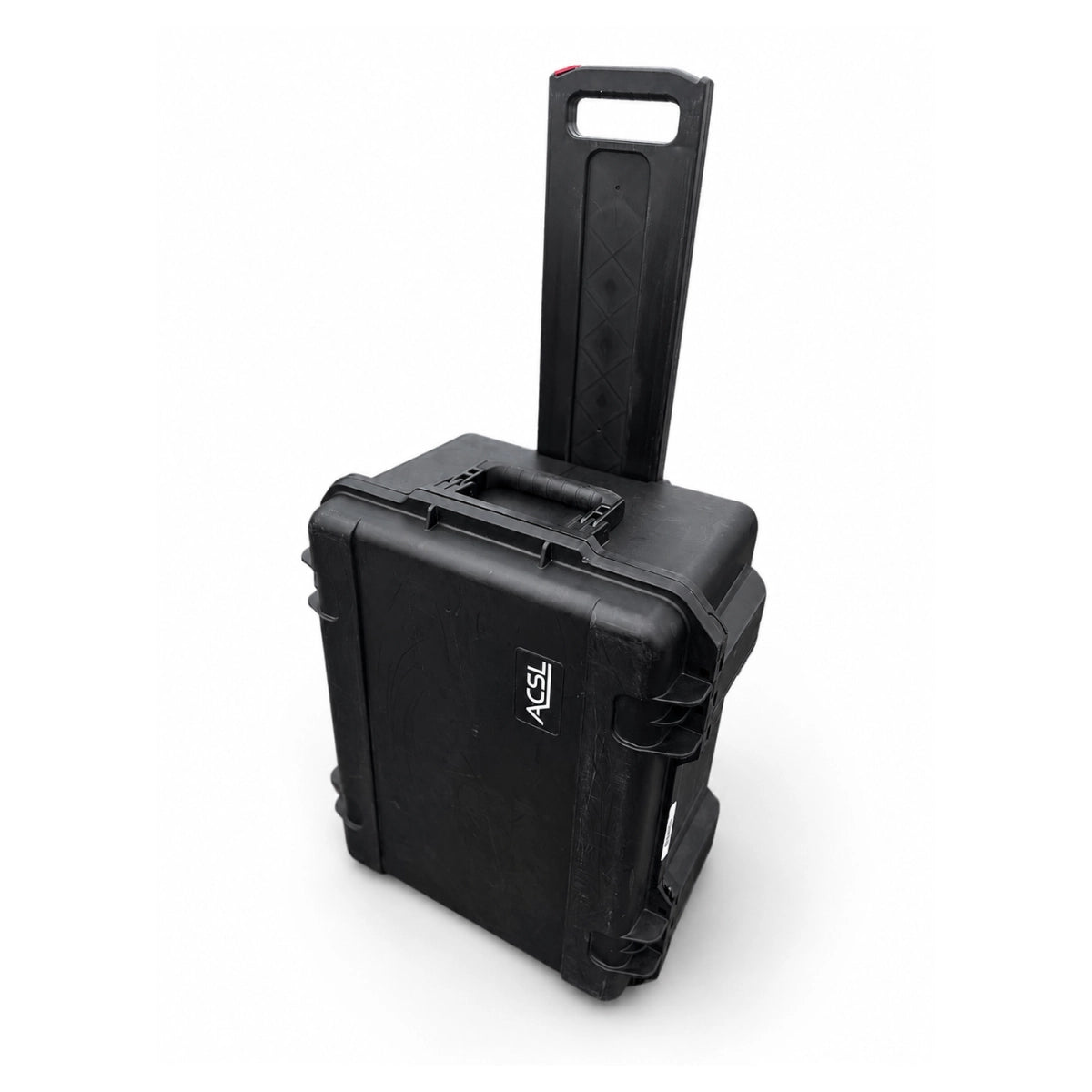
The ACSL SOTEN Agriculture Bundle Plus with Rapid Deployment Hard Case is the most comprehensively equipped SOTEN bundle for agricultural and environmental data collection workflows. It pairs Japan's NDAA-compliant SOTEN airframe with the TAITEN Smart Controller, the CX-GB300 Multispectral Camera, the CX-GB100 standard 20MP visible camera, five smart batteries, and a wheeled hard-shell case with custom blue foam interior.
Having both cameras in a single kit means operators arrive on site ready to collect multispectral crop data and high-resolution visible imagery in the same field session, swapping payloads in seconds without powering down the aircraft.
Key Features and Benefits
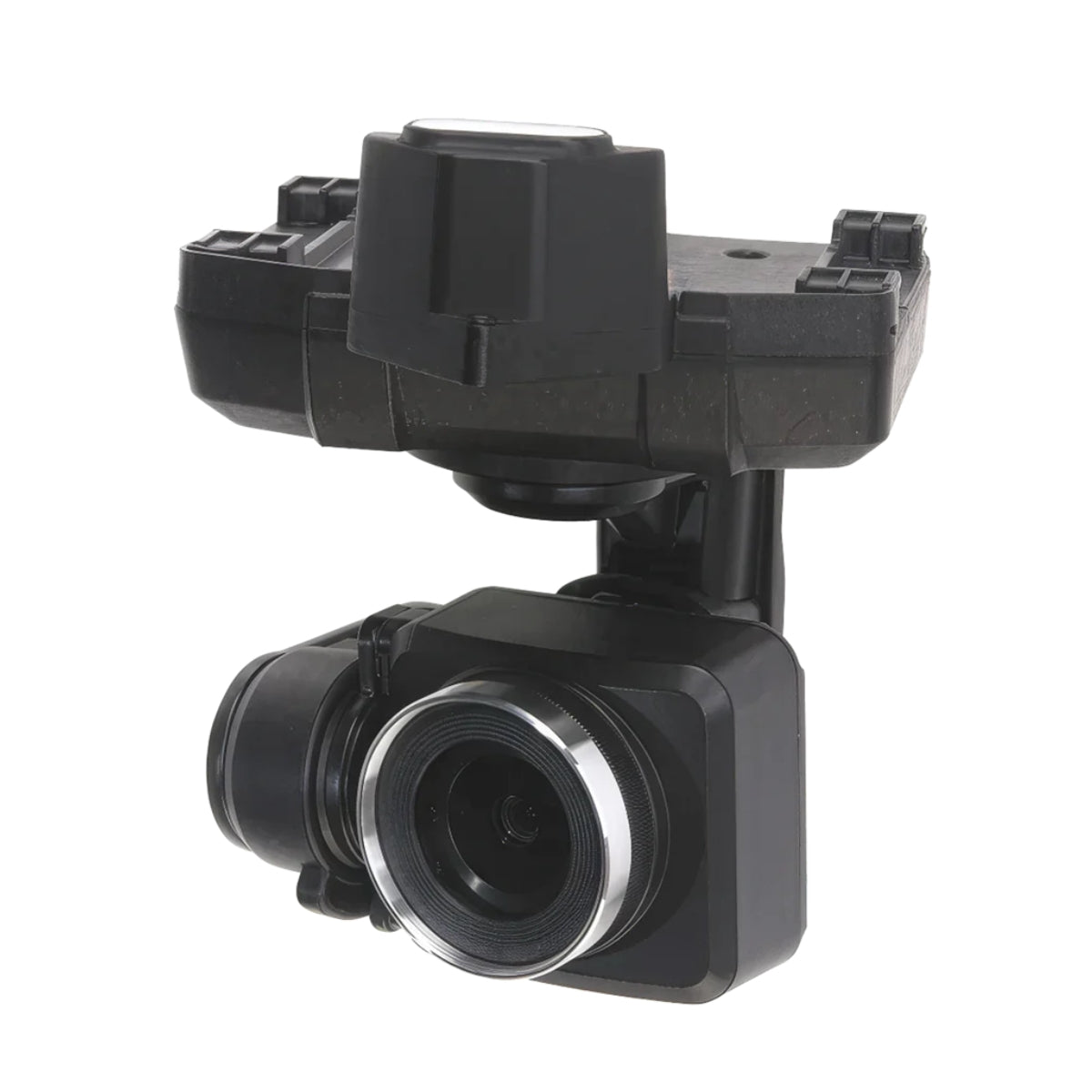
- Dual cameras included: CX-GB300 multispectral and CX-GB100 visible camera ship together in one kit.
- Multispectral imaging: 1-inch 20MP sensor with triple bandpass filter for calibrated crop data collection.
- Solar sensor: integrated on CX-GB300 for consistent light calibration across changing field conditions.
- RGB TIFF 16-bit output: analytical image format supports quantitative vegetation analysis workflows.
- NDAA compliance: aircraft and TAITEN controller both meet federal procurement requirements.
- One-touch swap: change between multispectral and visible payloads without powering down the aircraft.
- Five batteries: supports extended multi-sortie coverage across large agricultural field areas.
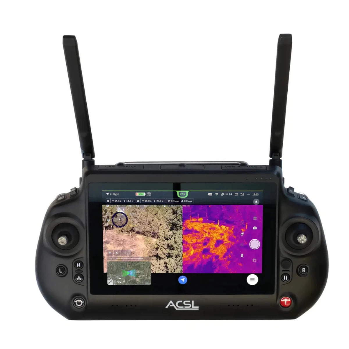
- TAITEN display: 7-inch 1500-nit panel with Android 13 and ACSL TAKEOFF pre-installed.
- IP43 airframe: resists rain and dust during active outdoor agricultural survey operations.
- AES-256 encryption: all communications and optional on-media storage are cryptographically secured.
The CX-GB300 is purpose-built for analytical imaging workflows. Its 1-inch 20MP sensor, triple bandpass filter, and integrated solar sensor work together to capture calibrated multispectral data in RGB TIFF 16-bit format, giving agronomists and field teams the image quality needed for crop health assessment, vegetation analysis, and field mapping.
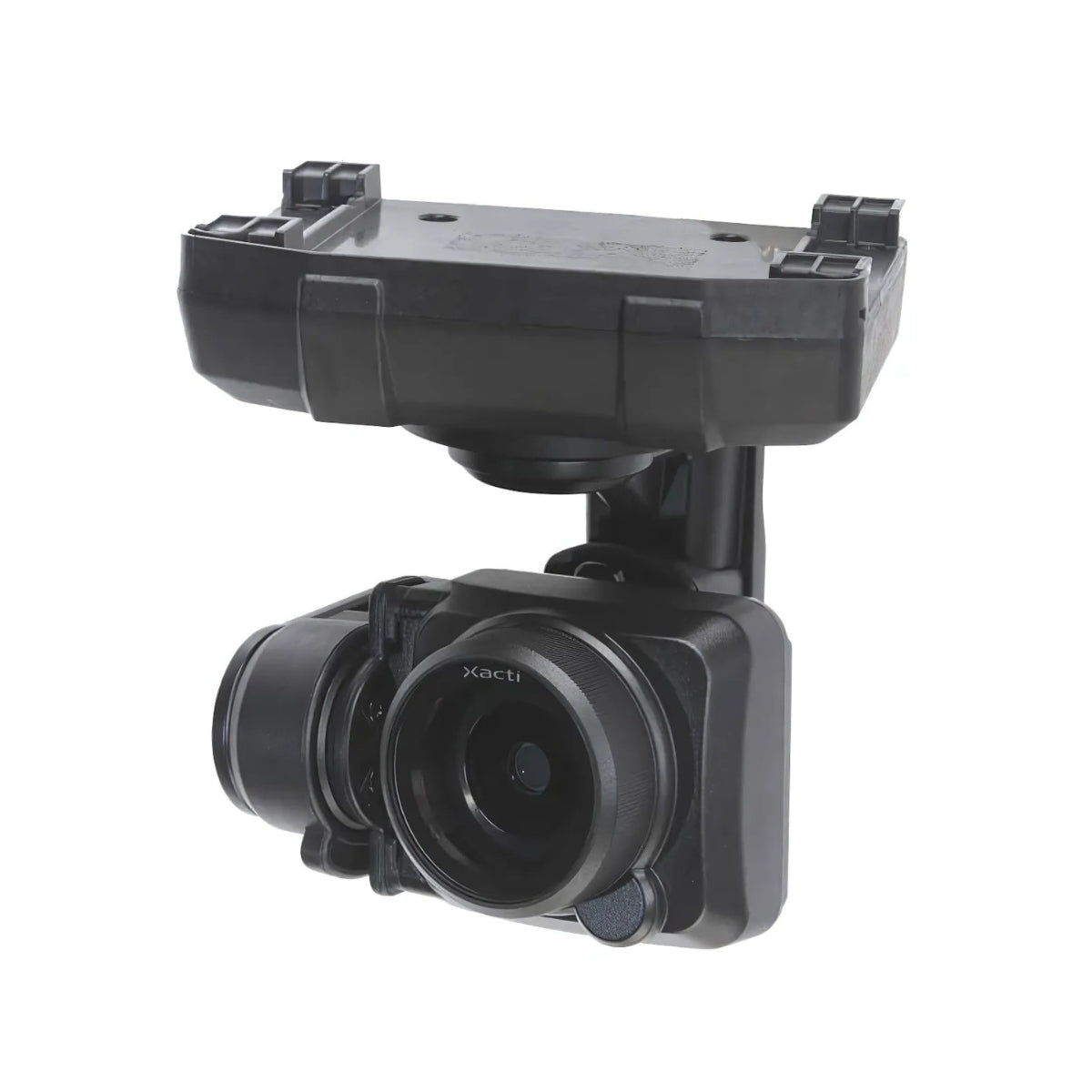
The CX-GB100 rounds out the kit with mechanical shutter stills at 20MP and 4K video at 30fps for detailed visual documentation of the same areas. Both cameras mount to the SOTEN's one-touch gimbal system, and the entire platform operates on AES-256 encrypted ACSL Fides-Link communications with a security architecture based on ISO/IEC 15408 principles, keeping collected agricultural data protected from flight through storage.
Two Sensors, One Deployment Window
Agricultural survey workflows benefit most when visual and multispectral data cover the same area in the same session. The Agriculture Bundle Plus makes that possible without purchasing a second aircraft or returning to base mid-mission.
The CX-GB300 captures calibrated multispectral imagery through its triple bandpass filter, while its integrated solar sensor compensates for changing light conditions across the field. Switch to the CX-GB100 for 20MP mechanical shutter stills and 4K video documentation of the same areas, all within a single flight deployment.
With 25 minutes of flight time per battery and five batteries in the kit, operators have enough endurance to cover meaningful acreage and collect both data types before the day is done.
Compatibility and System Integration
- CX-GB300 multispectral camera: included; 1-inch 20MP sensor with triple bandpass filter and solar sensor.
- CX-GB100 standard camera: included; 1-inch 20MP with mechanical shutter and 4K video output.
- SAMO high-resolution thermal camera: optional NDAA-compliant EO/IR payload (sold separately).
- CX-GB400 optical zoom camera: optional 2.5x optical with up to 25x combined zoom (sold separately).
- ACSL TAKEOFF app: pre-installed on TAITEN for flight, gimbal, and autonomous mission planning.
- ACSL Fides-Link: dual-band AES-256 encrypted link with 6-plus mile unobstructed range.
- ACSL SOTEN RTK Module: optional centimeter-level positioning accessory for precision mapping (sold separately).
- Optional LTE module: enables remote and closed-network operations for BVLOS workflows (sold separately).
Applications and Use Cases
- Crop health monitoring: collect multispectral data to identify stress, disease, and nutrient deficiencies.
- Vegetation analysis: generate repeatable spectral datasets for seasonal comparison and trend tracking.
- Field mapping: combine multispectral and visible capture for comprehensive aerial field documentation.
- Precision agriculture planning: support variable-rate input decisions with consistent aerial data collection.
- Irrigation assessment: identify dry zones and moisture distribution patterns across active field areas.
- Environmental monitoring: document vegetation changes across natural and managed land areas over time.
- Agronomy documentation: capture 20MP visual records alongside spectral data for field reporting workflows.
- Research operations: collect controlled multispectral and visible datasets for agricultural study programs.
The ACSL SOTEN Agriculture Bundle Plus with Rapid Deployment Hard Case is built for agricultural professionals who need both multispectral and visible data from a single, portable, and compliant platform.
The dual-camera kit, five-battery complement, and wheeled hard-shell case mean the system is organized, protected, and ready to deploy from the moment it arrives on site. For field operators running crop health programs where data quality and platform security both matter, this bundle delivers the tools to meet that standard in a single trip.
DSLRPros has extensive experience supporting enterprise UAS programs across agricultural and environmental monitoring applications. When you purchase the ACSL SOTEN Agriculture Bundle Plus through DSLRPros, you get application guidance and after-sale support from a team that understands how precision agriculture data workflows actually run in the field.
Order today at DSLRPros and put dual-sensor aerial capability to work on your next field mission.
