


Drone Software for Mapping, Fleet Management, Photogrammetry, and LiDAR Processing
A drone by itself collects data — images, video, GPS coordinates, LiDAR returns. Drone software is what turns that raw data into something usable: a georeferenced map a surveyor can submit to a client, a thermal anomaly report an inspector can attach to a maintenance ticket, a flight log an agency can produce for a regulatory audit, or a live video feed a command center can act on in real time. Without the right software, a drone program captures data it cannot process, share, or defend. With the right software stack, the same hardware produces certified deliverables, auditable compliance records, and actionable intelligence — the actual outputs that justify the cost of the program.
Drone software falls into several functional categories that serve different stages of operations. Flight management platforms handle mission planning, live monitoring, and fleet coordination during active flights. Post-processing platforms transform captured imagery into maps, 3D models, point clouds, and vegetation indices after landing. Compliance and analytics platforms ingest flight logs to track equipment health, operator performance, and regulatory adherence over time. Specialized tools handle specific workflows — power line corridor analysis, precision agriculture multispectral processing, emergency rapid mapping, CAD-compatible survey extraction — that general-purpose platforms do not cover in depth. Most professional drone programs need platforms from more than one of these categories, because a single tool rarely covers the full workflow from pre-flight planning through final deliverable.
This collection covers the drone software licenses and subscriptions DSLRPros stocks across all four categories. The platforms span flight operations and fleet management (DJI FlightHub 2, Airdata, FlytBase), photogrammetric mapping and 3D modeling (DJI Terra, PIX4Dmapper, PIX4Dmatic, PIX4Dcloud), industry-specific applications (PIX4Dfields for agriculture, PIX4Dreact for emergency response, PIX4Dsurvey for CAD integration, Autel Mapper for Autel fleets), and LiDAR point cloud processing (GreenValley LiDAR360, GreenValley LiPowerline). The right combination depends on your aircraft platform, your mission type, and whether you need real-time operations management, post-flight data processing, or both.
DSLRPros carries perpetual, annual, and monthly licensing options across all vendors where available. Our team provides pre-purchase guidance on platform selection, license tiers, and software-hardware compatibility for every program we stock.
Software by Function: What Each Platform Does
| Platform | Function Category | Primary Use What It Does | Who It's For Best Fit | Platform Dependency Works With |
|---|---|---|---|---|
| DJI FlightHub 2 | Fleet management and live operations | Real-time fleet monitoring, mission planning, dock management, live video feeds, AI detection | DJI enterprise fleet operators, autonomous dock programs | DJI enterprise aircraft and Dock 2/3 only |
| Airdata Enterprise | Flight compliance and analytics | Post-flight log analysis, maintenance tracking, compliance reporting, live streaming (add-on) | Multi-drone programs needing auditable flight records and operator accountability | DJI, Autel, Skydio — multi-manufacturer |
| FlytBase Enterprise (Dock 2) | Autonomous fleet automation | AI-powered detection, alarm integration, automated mission response for Dock 2 deployments | Security and monitoring programs on DJI Dock 1 and Dock 2 | DJI Dock 1 and Dock 2 (Matrice 3D/3TD) |
| DJI Terra | Mapping and 3D reconstruction | 2D orthomosaics, 3D point clouds, real-time mapping during flight; DJI hardware optimized | DJI drone operators needing quick mapping outputs within the DJI ecosystem | DJI enterprise aircraft; limited sensor compatibility |
| PIX4Dmapper | Photogrammetric mapping (desktop) | Survey-grade 2D maps and 3D models from drone, handheld, or aerial imagery; offline processing | Surveyors, GIS professionals, engineers requiring accuracy-critical deliverables | Hardware-agnostic; wide sensor compatibility |
| PIX4Dmatic | Large-scale mapping (desktop/cloud) | High-volume corridor and large-area dataset processing; faster than Mapper for scale | Large survey programs, corridor mapping, LiDAR + imagery combined workflows | Hardware-agnostic; LiDAR and imagery |
| PIX4Dcloud | Cloud mapping and collaboration | Browser-based photogrammetry, team sharing, progress tracking, site documentation | Teams needing cloud-based processing without local workstation requirements | Hardware-agnostic; imagery-based |
| PIX4Dfields | Agricultural mapping | Crop health maps, NDVI/multispectral analysis, fast field-level processing for ag programs | Agronomists, farmers, precision ag consultants with multispectral payloads | Hardware-agnostic; multispectral and RGB |
| PIX4Dreact | Emergency response mapping | Rapid 2D orthomosaic generation in minutes for incident command and disaster response | First responders, public safety agencies, emergency management teams | Hardware-agnostic; optimized for speed |
| PIX4Dsurvey | Survey CAD integration | Extracts vector files from point clouds and photogrammetry for CAD and land survey workflows | Licensed surveyors and engineering firms integrating drone data into CAD | Works with PIX4Dmapper, LiDAR, and other point cloud outputs |
| Autel Mapper | Mapping (Autel-optimized) | 3D models and geospatial data outputs; optimized for Autel drone platforms | Autel EVO and Alpha fleet operators needing integrated mapping | Autel drones; limited DJI compatibility |
| GreenValley LiDAR360 | LiDAR point cloud processing | Classification, feature extraction, DTM/DSM generation, and analysis from LiDAR datasets | Survey and mapping programs processing LiDAR data from any platform | Hardware-agnostic; LiDAR point cloud files |
| GreenValley LiPowerline | Power line LiDAR analysis | Automated power line extraction, vegetation encroachment analysis, corridor modeling from LiDAR | Utility inspection programs processing LiDAR corridor data | Hardware-agnostic; LiDAR point cloud files |
Scroll horizontally to view all platform details.
Flight Operations and Fleet Management Software
DJI FlightHub 2 is a cloud-based fleet management and live operations platform for DJI enterprise aircraft and DJI Dock infrastructure. It handles real-time telemetry monitoring across multiple aircraft, mission planning and route synchronization, simultaneous live video feeds from multiple drones, virtual cockpit remote control, AI-powered detection of people, vehicles, and vessels, and full integration with DJI Dock 2 and Dock 3 for autonomous sortie management. FlightHub 2 is available in cloud and on-premises versions for programs with data sovereignty requirements. It operates exclusively within the DJI ecosystem and does not support Autel, Skydio, or other manufacturer aircraft.
Airdata Enterprise is a fleet management and flight compliance platform supporting DJI, Autel, and Skydio aircraft from a single dashboard. Unlike FlightHub 2, Airdata does not produce maps or manage live flight operations — it focuses on post-flight log analysis, maintenance scheduling, operator accountability records, and compliance reporting for programs where auditable flight data is a regulatory or organizational requirement. Airdata is the correct choice for agencies running mixed-manufacturer fleets or for programs where post-flight analytics and compliance documentation are as important as real-time operations. The Enterprise + Live Streaming add-on extends the platform with live video streaming capability for up to 5 drones and 5 users. The Enterprise + Asset Management bundle adds drone and equipment inventory tracking for organizations managing physical assets alongside flight programs.
FlytBase Enterprise Base Package for Dock 2 is an AI-powered autonomous operations platform for programs running DJI Dock 1 and Dock 2 with Matrice 3D/3TD aircraft. FlytBase adds capabilities beyond what DJI FlightHub 2 provides natively on those platforms — automated threat detection, perimeter alarm integration, and advanced automated mission response logic for security and monitoring programs. For Dock 3 programs, DJI FlightHub 2 and the DJI Cloud API are the primary software path; confirm FlytBase compatibility with Dock 3 directly with FlytBase before purchasing.
Photogrammetric Mapping and 3D Processing Software
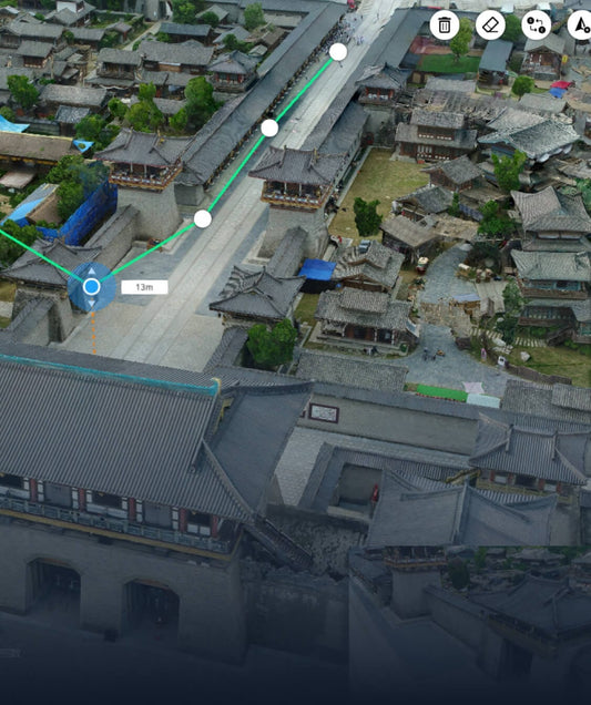
DJI Terra is DJI's integrated mapping and 3D reconstruction software, optimized for DJI enterprise aircraft and designed to produce 2D orthomosaics, 3D point clouds, and real-time mapping outputs during flight. It is the simplest entry point for DJI operators who want mapping outputs without learning a third-party platform. Its limitations are platform dependence — it works natively with DJI aircraft and is not designed for sensors from other manufacturers — and it does not produce survey-grade results equivalent to PIX4Dmapper or comparable photogrammetry platforms. For DJI operators running standard mapping workflows on a single-manufacturer fleet, Terra is a practical choice. For programs requiring survey-grade accuracy, broad sensor compatibility, or offline desktop processing control, PIX4Dmapper or PIX4Dmatic is the correct platform.
The PIX4D suite is a modular photogrammetry platform where each product targets a specific use case, scale, or industry. PIX4D is hardware-agnostic — it processes imagery from DJI, Autel, Inspired Flight, Freefly, Sony, and other cameras without proprietary restrictions.
- PIX4Dmapper: desktop photogrammetry software for survey-grade 2D maps and 3D models from drone, handheld, or aerial imagery; supports ground control points for centimeter-level absolute accuracy; offline processing with no cloud dependency; the standard choice for surveyors, GIS professionals, and engineers who require accuracy-critical deliverables on a controlled processing workstation
- PIX4Dmatic: designed for large-volume datasets and corridor mapping — processes more images faster than Mapper and handles combined LiDAR and imagery workflows; the correct choice for programs running large-area surveys, linear corridor mapping (power lines, pipelines, railways), or high-frequency repeat surveys where processing speed and dataset scale are constraints
- PIX4Dcloud: browser-based photogrammetry processing and team collaboration platform; no local workstation required; supports site progress documentation, team annotation sharing, and volume measurements accessible from any browser; suitable for construction and site monitoring programs that need cloud-accessible outputs without desktop software management
- PIX4Dreact: rapid 2D mapping for emergency response — generates orthomosaic maps from drone imagery in minutes rather than hours; designed for incident command, disaster assessment, and search and rescue programs where turnaround speed is operationally critical and full photogrammetric accuracy is secondary to fast situational awareness
- PIX4Dfields: agriculture-specific mapping platform that processes multispectral and RGB imagery into crop health maps, NDVI and NDRE indices, and field-level analysis outputs compatible with precision agriculture decision tools; works with MicaSense, Sentera, DJI multispectral, and other ag sensors
- PIX4Dsurvey: bridges photogrammetry and CAD by extracting vector files — contour lines, breaklines, 3D polylines — from PIX4Dmapper point cloud outputs and LiDAR data; designed for licensed surveyors and engineering firms that deliver CAD-compatible survey products rather than raster orthomosaic outputs
LiDAR Processing Software
GreenValley LiDAR360 is a professional LiDAR point cloud processing platform covering the full workflow from raw scan data to classified deliverables — ground filtering, vegetation classification, building extraction, DTM/DSM generation, volumetric analysis, and feature extraction. It is hardware-agnostic and processes LiDAR datasets from any airborne or terrestrial scanner. For programs running the Zenmuse L3 on the Matrice 400 or GreenValley LiDAR hardware on fixed-wing platforms, LiDAR360 handles the full post-flight processing pipeline.
GreenValley LiPowerline is a specialized LiDAR analysis tool for power line corridor programs — it automates conductor extraction, tower identification, vegetation encroachment flagging, and clearance distance calculation from LiDAR datasets. For utility inspection programs that collect LiDAR data along transmission corridors, LiPowerline eliminates the manual classification work that general-purpose LiDAR platforms require for power line deliverables.
Industry-Specific Software by Mission Type
- Mapping and cadastral survey: PIX4Dmapper (accuracy-critical, offline) or PIX4Dmatic (large volume/corridor) — hardware-agnostic, survey-grade outputs with GCP support
- Construction progress and site documentation: PIX4Dcloud (cloud collaboration, progress tracking) or DJI Terra (DJI-native, quick outputs)
- Emergency response and public safety mapping: PIX4Dreact — fastest time-to-map for incident command and disaster assessment
- Precision agriculture: PIX4Dfields (multispectral analysis and NDVI) — compatible with MicaSense RedEdge-P, Sentera 6X, and DJI multispectral payloads
- Power line LiDAR inspection: GreenValley LiPowerline for corridor analysis; GreenValley LiDAR360 for general point cloud classification
- DJI fleet live operations and dock management: DJI FlightHub 2 — required for Dock 3 autonomous operations and real-time multi-aircraft coordination
- Multi-manufacturer fleet compliance: Airdata Enterprise — the only platform in this collection supporting DJI, Autel, and Skydio from a single dashboard
- Autel fleet mapping: Autel Mapper — optimized for Autel EVO and Alpha platforms
- DJI Dock 2 autonomous security monitoring: FlytBase Enterprise — AI detection and alarm integration for Dock 1/2 deployments
- CAD-compatible survey deliverables: PIX4Dsurvey — extracts vector files from point clouds for engineering and licensed survey workflows
Choosing Between FlightHub 2 and Airdata
This is the most common comparison question for DJI fleet operators. The two platforms are not direct competitors — they solve different problems at different stages of the flight workflow.
DJI FlightHub 2 is a live operations system: it manages active flights, coordinates multiple aircraft in real time, integrates with Dock 2 and Dock 3 for autonomous dispatch, and provides mission planning, live video, and AI detection during operations. It is only useful while missions are running and only works with DJI hardware.
Airdata is a post-flight system: it ingests flight logs after landing, analyzes them for safety events, equipment anomalies, and operator performance metrics, and generates compliance and maintenance reports. It supports multiple drone manufacturers and is the platform that enterprise programs use to demonstrate regulatory compliance, track equipment health, and produce the audit trail that insurance programs and government agencies require.
For DJI-only fleets running dock-based autonomous operations, FlightHub 2 is the primary operations platform and Airdata can supplement it for compliance documentation. For mixed-manufacturer fleets, Airdata is the common analytics layer across all aircraft regardless of brand. For programs where compliance reporting is a contractual or regulatory requirement, Airdata is not optional regardless of which operations platform the fleet uses.
Frequently Asked Questions
What is the difference between PIX4Dmapper and PIX4Dmatic?
Both are desktop photogrammetry platforms for professional mapping, but they target different scales and workflows. PIX4Dmapper is the standard platform for survey-grade 2D maps and 3D models from smaller datasets — it supports a wide range of sensors, GCP integration for centimeter-level accuracy, and detailed processing control for individual projects. PIX4Dmatic is designed for high-volume, large-area, and corridor datasets where processing speed and the ability to handle combined LiDAR and imagery data are priorities. For most survey and mapping programs operating at standard project scales, Mapper is the entry point; programs running large-area surveys, linear corridor mapping, or high-frequency repeat missions at scale benefit from Dmatic's processing capacity.
Does DJI FlightHub 2 work with non-DJI drones?
No. DJI FlightHub 2 is a DJI-native platform that works exclusively with DJI enterprise aircraft and DJI Dock 2/3 infrastructure. It does not support Autel, Skydio, Inspired Flight, ACSL, or other non-DJI platforms. For programs managing mixed-manufacturer fleets, Airdata Enterprise supports DJI, Autel, and Skydio from a single dashboard. For Inspired Flight IF800 or IF1200 fleet management, check with Inspired Flight for recommended third-party operations platforms.
What PIX4D product do I need for precision agriculture?
PIX4Dfields is the agriculture-specific PIX4D product — it processes multispectral and RGB imagery into crop health maps, NDVI and NDRE vegetation indices, and field-level outputs compatible with precision agriculture decision tools. It is optimized for fast field processing in the field or office rather than the full photogrammetric accuracy of PIX4Dmapper. Compatible sensors include MicaSense RedEdge-P, MicaSense Altum-PT, Sentera 6X multispectral, and DJI Zenmuse P1 (RGB band). PIX4Dmapper can also process multispectral data for programs requiring survey-grade geospatial outputs from the same imagery, at additional processing time and complexity.
What is PIX4Dsurvey used for and do I need it in addition to PIX4Dmapper?
PIX4Dsurvey is a specialized tool for licensed surveyors and engineering firms who need to extract vector survey data — contour lines, breaklines, 3D polylines — from photogrammetry point clouds or LiDAR datasets for use in CAD environments like AutoCAD, Civil 3D, or Trimble. It bridges the gap between photogrammetric outputs (which are raster-based) and the vector deliverables that land survey and civil engineering workflows require. If your deliverable is an orthomosaic, DEM, or 3D model, PIX4Dmapper alone is sufficient. If your deliverable is a CAD-compatible survey file for engineering or cadastral use, PIX4Dsurvey is the additional processing step that makes that output possible.
What is GreenValley LiPowerline and how does it differ from LiDAR360?
GreenValley LiDAR360 is a general-purpose LiDAR point cloud processing platform — it handles the full workflow from raw scan data to classified deliverables across any application: terrain modeling, vegetation analysis, building extraction, volumetric calculation. LiPowerline is a specialized module built specifically for power line corridor analysis — it automates conductor and tower extraction, flags vegetation encroachment against clearance distance thresholds, and generates corridor-specific deliverables that would require extensive manual work in LiDAR360 alone. Utility inspection programs processing corridor LiDAR data typically use both: LiDAR360 for general point cloud classification and LiPowerline for the power line-specific analysis and reporting outputs.
Shop Drone Software at DSLRPros
The right drone software stack depends on your aircraft platform, your output requirements, and whether your program prioritizes real-time operations, post-flight processing, compliance documentation, or a combination. DSLRPros carries licensing options across all tiers and vendors in this collection — monthly, annual, and perpetual where available — and our team provides pre-purchase guidance to match software to your specific workflow before you commit to a license.
Contact DSLRPros to discuss software selection for your program or to request a quote on multi-seat enterprise licensing for any platform in this collection.
