


PIX4D: Accuracy at Your Fingertips
PIX4D is a developer of cutting-edge software that converts images taken by hand, by drone, or by plane into survey-grade accurate and georeferenced 2D mosaics, 3D models and point clouds. Founded in 2011, it is rapidly expanding from its headquarters in Lausanne, Switzerland, to offices in San Francisco, Shanghai, Berlin, Madrid, Tokyo and Denver.
No matter your organization's vertical, there's a PIX4D software that can help you get measurable, actionable data from your aerial photos. For accident reconstruction, natural disaster response, or detailed planning for any situation, Pix4Dreact is a quick and efficient tool to get the data you need to get the job done.
Trying to decide whether PIX4D is the right fit—or how it compares to other platforms like DroneDeploy and DJI Terra? Our in-depth comparison breaks down each tool’s strengths, features, and best-use cases to help you choose with confidence. Read the full article here: What Is the Difference Between PIX4D, DroneDeploy, and DJI Terra?.
PIX4Dmapper
PIX4Dmapper is the professional photogrammetry software that transforms your images into accurate and georeferenced digital spatial models. Using a desktop computer, automatically convert images taken by drone, by hand, or by plane into highly precise 2D maps and 3D models. These outputs are customizable, timely, and complement a wide range of applications and software across industries.
Pix4Dmapper users have access to personal customer support and to a wealth of learning resources and training to help them become experts.
PIX4Dreact
PIX4DReact software is a quick mapping software that provides emergency responders with rapid, accurate situational awareness in the field. It allows users to make decisions on where they need their resources quickly so teams can work more efficiently together.
PIX4Dfields
PIX4Dfields is the leading agriculture mapping software, allowing farmers and agronomists to collect, process, and visualize data for detailed crop analysis. With PIX4Dfields, you can create high-resolution maps and 3D models of your fields, identify areas of stress or potential yield loss, and make informed decisions about irrigation, fertilizer applications, and other management practices.
PIX4Dmatic
PIX4Dmatic is a cutting-edge software designed for terrestrial, corridor and large scale mapping, and it's the perfect solution for anyone who wants to create high-quality maps and 3D models.
PIX4Dcloud
PIX4Dcloud is the definitive online platform for drone mapping. With its easy-to-use interface and powerful photogrammetry software algorithms, it's the perfect tool for progress tracking, site documentation, and more.
PIX4Dsurvey
PIX4Dsurvey is a software that was developed with help from surveyors to extract vector files from point data, photogrammetry, and Lidar. It bridges the gap between photogrammetry and CAD.
PIX4Dcapture
PIX4Dcapture is a flight planning mobile app. Use it to easily plan and execute your drone flight for mapping and 3D modeling. Free drone flight planning and image acquisition app with seamless integration to PIX4D photogrammetry software. Available for Android and iOS. Simple Workflow: Select a drone. Select a mission. Adjust the flight plan & parameters. Start & Fly. Check the results.
PIX4D's software has become too extensive that is now used by public safety, surveying, construction, mining, and agricultural professionals to make quick and accurate measurements of large areas. It is also used by researchers to study environmental change, map archaeological sites, monitor wildlife populations, and more.
Aerial Software Suite in Action Across Sectors
PIX4D is a leading photogrammetry and mapping software suite designed to transform aerial and ground-based imagery into accurate, detailed, and actionable geospatial data. Its specialized modules and versatile capabilities make it a go-to solution for a wide range of industries that rely on precise mapping, modeling, and measurement.
-
Surveying and Mapping
PIX4Dmapper enables land surveyors and GIS professionals to create highly accurate 2D maps and 3D models from aerial images. It supports ground control points (GCPs) for centimeter-level precision, making it ideal for cadastral surveys, topographic mapping, and infrastructure planning.
-
Construction and Infrastructure
Construction firms use PIX4D to monitor site progress, measure earthworks, and verify project specifications. Detailed orthomosaics and point clouds help project managers track timelines, improve communication with stakeholders, and reduce costly rework.
-
Mining and Quarrying
In mining operations, PIX4D provides precise volumetric calculations for stockpiles, pit progression, and excavation planning. This reduces the need for manual measurements, increases safety, and enables more frequent and accurate reporting.
-
Agriculture and Forestry
PIX4Dfields processes multispectral imagery to deliver crop health maps, vegetation indices, and yield predictions. Farmers and agronomists can use these insights to optimize irrigation, fertilizer application, and pest control, while forestry teams can monitor growth and assess forest health.
-
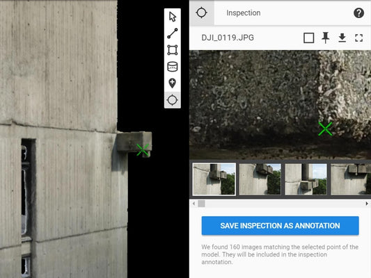
Inspection and Asset Management
PIX4Dinspect automates the creation of 3D models of vertical structures like cell towers, wind turbines, and bridges from drone images. These models allow engineers to conduct remote inspections, identify defects, and schedule maintenance without physical climbing.
-
Public Safety and Emergency Response
PIX4Dreact is designed for rapid 2D mapping in disaster or emergency scenarios. It helps first responders and humanitarian organizations quickly generate situational awareness maps for search and rescue, damage assessment, and recovery planning.
-
Environmental Monitoring and Conservation
Environmental scientists use PIX4D to monitor changes in landscapes, track erosion, study wildlife habitats, and assess the impact of human activities. The ability to capture temporal data makes it a valuable tool for conservation projects and climate studies.
-
Urban Planning and Smart Cities
City planners employ PIX4D to model urban environments, assess infrastructure needs, and plan expansions. The software's accurate and detailed 3D models facilitate better decision-making and public consultation processes.
From surveying vast terrains to inspecting complex infrastructure, PIX4D has proven itself as a versatile and dependable solution across numerous industries. Its ability to deliver precise, actionable data from aerial and ground images empowers professionals to work faster, safer, and more efficiently.
Enhance your geospatial analysis, real-time mapping, and aerial survey projects with PIX4D.
