


Freefly Flux O1
Freefly Flux O1
SKU:S-FF-FLUX-01


- Description
- Specifications
- In the Box
- FAQ
Freefly Flux O1: NDAA-Compliant Airborne LiDAR Payload With 5.2M Points Per Second and 200 m Range
The Freefly Flux O1 is a compact, NDAA-compliant LiDAR payload built for operators who need high-density point cloud data from sensitive or regulated sites without the complexity of proprietary software ecosystems.
Powered by the Ouster OS1 scanner, it delivers 5,242,880 points per second across a 360°×42.4° field of view, with ±3 cm accuracy and ±0.5 cm precision at ranges up to 200 m (656 ft).
Weighing just 633 grams — the lightest payload in Freefly's Flux lineup — the O1 mounts via integrated Smart Dovetail to the Freefly Astro, Astro Max, and Alta X Gen2, and exports directly to LAS or LAZ with no software subscription or ongoing maintenance cost.
Key Features and Benefits
- Ouster OS1 scanner: delivers 5,242,880 points per second at up to 200 m range.
- 360°×42.4° FOV: full horizontal sweep with meaningful vertical coverage in a single pass.
- ±3 cm accuracy: ±0.5 cm precision for survey-grade point cloud data collection.
- Dual laser returns: captures clean data through vegetation, complex surfaces, and structures.
- Dual full-band GNSS: U-blox X20 receivers covering L1, L2, L5, and L6 for PPK processing.
- Ximea 20MP RGB camera: captures colorized point cloud data in the same flight pass.
- 633 g total weight: lightest payload in the Freefly Flux lineup for maximum aircraft endurance.
- Smart Dovetail mount: tool-free, secure integration with Freefly Astro, Astro Max, and Alta X Gen2.
- LAS and LAZ export: industry-standard output formats with no software subscription required.
- NDAA compliant: approved for government, defense, and critical infrastructure project use.
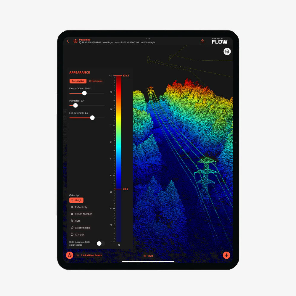
The O1's PPK workflow is built around dual full-band GNSS receivers — dual U-blox X20 modules covering L1, L2, L5, and L6 — paired with the free Freefly Flow app on an Apple M-Series iPad. An M3 iPad processes at four times real time, turning an eight-minute flight into approximately two minutes of post-processing.
The integrated Ximea 20MP RGB camera captures colorized point cloud data in the same pass, and dual laser returns ensure clean data collection across complex surfaces and vegetation. For survey teams, infrastructure inspectors, and government contractors working on sites where foreign-manufactured hardware is not an option, the Flux O1 provides a clear, capable, and compliant path to airborne LiDAR data.
Survey-Grade Data From a Platform Built for Regulated Environments
The Flux O1's value proposition is straightforward: it puts Ouster OS1 point cloud performance into a form factor that meets federal procurement requirements and fits the Freefly Smart Dovetail ecosystem without requiring a software license to unlock the data.
The dual U-blox X20 GNSS receivers cover all four bands — L1, L2, L5, and L6 — which is a hard requirement for the PPK workflow; a dual-band base station will not produce accurate results. Post-processing runs through the free Freefly Flow app on any M-Series iPad, with no cloud dependency and no recurring cost.
At 633 grams, the O1 preserves aircraft endurance on the Astro and Astro Max, and the 5.2 million points per second throughput means operators capture the detail they need in fewer passes — reducing flight time, battery consumption, and mission complexity on every job.
Freefly Flux LiDAR Payload Comparison
| Category | Flux O1 | Flux L1 | Flux H1 |
|---|---|---|---|
| Scanner | Ouster OS1 | Livox Avia | Hesai XT-32MX |
| Points / sec | 5,242,880 | 720,000 | 1,920,000 |
| Range | ~200 m | 450 m | 300 m |
| Field of view | 360° × 42.4° | 70° × 77° | 360° × 40.3° |
| Accuracy | ±3 cm | ±5 cm | ±1 cm |
| Precision | 0.5 cm | 2 cm | 0.5 cm |
| Laser returns | 2 | 3 | 3 |
| Weight | 633 g | 715 g | 715 g |
| Scan pattern | Repetitive | Non-repetitive | Repetitive |
| NDAA | Yes | No | No |
| RGB camera | Ximea 20MP | Ximea 20MP | Ximea 20MP |
Compatibility and System Integration
- Freefly Astro: direct Smart Dovetail integration; GNSS mounts included in box.
- Freefly Astro Max: direct Smart Dovetail integration; GNSS mounts included in box.
- Freefly Alta X Gen2: compatible with GNSS Mount (sold separately).
- Freefly Flow app: free iPad app for PPK post-processing; requires Apple M-Series iPad.
- Full-band GNSS base station: L1, L2, L5, and L6 required; dual-band (L1/L2) will not work.
- NTRIP service: full-band equivalent accepted in place of physical base station.
- LAS/LAZ output: compatible with standard survey and GIS software workflows.
Applications and Use Cases
- Government and critical infrastructure surveys: NDAA compliance supports federal procurement requirements.
- Infrastructure inspection: 200 m range and 5.2M points per second capture structural detail at altitude.
- Topographic and terrain mapping: 360° horizontal FOV and dual returns produce clean ground models.
- Vegetation and forestry surveys: dual laser returns penetrate canopy for accurate ground surface data.
- Corridor and utility inspection: full 360° sweep covers linear assets in a single flight pass.
- Construction and site documentation: ±3 cm accuracy meets survey-grade project requirements.
- AEC and as-built capture: colorized point clouds from the integrated 20MP RGB camera support design workflows.
The Flux O1 closes a specific gap in the airborne LiDAR market: a lightweight, NDAA-compliant payload that delivers Ouster OS1 performance without locking operators into a software subscription or a proprietary data ecosystem.
For field teams working on regulated sites where data security and component sourcing matter as much as point cloud density, it is a purpose-built answer to a procurement problem that has historically forced difficult compromises.
DSLRPros has supported professional UAV operators across survey, inspection, and infrastructure applications for decades, and the Freefly Flux O1 represents exactly the kind of purpose-built, compliance-forward capability that belongs in that lineup.
When you order the Flux O1 through DSLRPros, you get the product expertise and configuration support to pair it correctly with your aircraft, base station, and post-processing workflow.
Contact DSLRPros today to discuss your system requirements or place your order.
