


Freefly Flux L1
Freefly Flux L1
SKU:S-FF-FLUX-L1


- Description
- Specifications
- In the Box
- FAQ
Freefly Flux L1: Long-Range Airborne LiDAR Payload With 450 m Range and Non-Repetitive Scanning
The Freefly Flux L1 is the entry point to professional airborne LiDAR in the Freefly Flux lineup: a compact, capable payload that brings long-range scanning and a zero-subscription data pipeline to operators who need high-value 3D capture without the price tag of a top-tier system.
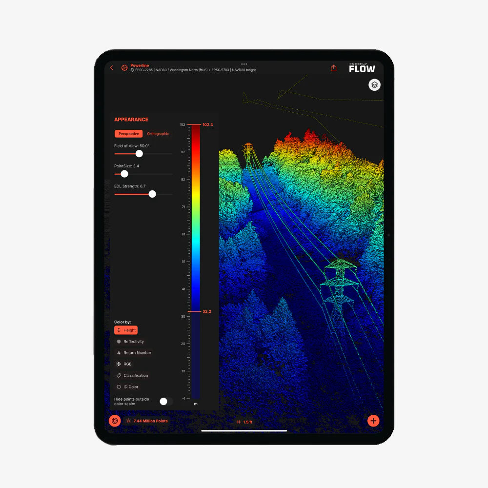
Powered by the Livox Avia scanner, it delivers 720,000 points per second across a 70°×77° field of view at ranges up to 450 m (1,476 ft), with a non-repetitive scanning pattern that provides complete coverage of complex structures like power lines, forest canopy, and hard-to-map assets that conventional repetitive scanners can miss.
At 715 grams with an integrated Smart Dovetail mount, it deploys directly on the Freefly Astro, Astro Max, and Alta X Gen2 without adapters or custom rigging.
Key Features and Benefits
- Livox Avia scanner: 720,000 points per second at ranges up to 450 m (1,476 ft).
- 70°×77° field of view: non-repetitive scanning pattern covers complex structures completely.
- ±5 cm accuracy: 2 cm precision for reliable professional-grade 3D data collection.
- Three laser returns: additional return fidelity for layered and partially obstructed surfaces.
- 450 m range: extended reach for power line inspection, forestry, and elevated terrain mapping.
- Dual U-blox X20 GNSS: full-band L1/L2/L5/L6 receivers support PPK post-processing workflow.
- Ximea 20MP RGB camera: colorizes point cloud data in the same flight pass.
- 715 g payload weight: compact form factor optimized for long endurance flights.
- Smart Dovetail mount: tool-free integration with Freefly Astro, Astro Max, and Alta X Gen2.
- LAS and LAZ export: industry-standard output with no software subscription required.
The L1's PPK workflow follows the same architecture as the rest of the Flux lineup: dual U-blox X20 full-band GNSS receivers covering L1, L2, L5, and L6 log correction data throughout the flight, and post-processing runs through the free Freefly Flow app on an Apple M-Series iPad with no software subscription or recurring cost. An M3 iPad processes at approximately four times real time, turning an eight-minute flight into roughly two minutes of output.
The integrated Ximea 20MP RGB camera captures colorized point cloud data in the same pass, and three laser returns — one more than the Flux O1 — provide additional data fidelity through layered or partially obstructed surfaces.
For survey professionals, utility inspectors, and forestry teams who need extended range and non-repetitive scanning coverage at a practical price point, the Flux L1 delivers a purpose-built answer.
Extended Range and Non-Repetitive Scanning at a Practical Entry Price
The Flux L1's operational value is defined by two characteristics that its price point does not typically unlock: 450 m range and a non-repetitive scanning pattern. Conventional LiDAR scanners repeat the same scan line on every rotation, which means thin or isolated targets — overhead power lines, individual branches, narrow structural members — can fall between scan lines and be missed entirely.
The Livox Avia's non-repetitive pattern continuously varies the beam direction within its field of view, increasing the probability of detecting fine or complex targets with each additional second of dwell time.
At 450 m, it also operates well above the altitudes where most medium-class payloads begin to lose effective density, making it practical for corridor inspections, forest surveys, and terrain mapping across large areas where flight altitude directly affects coverage efficiency.
Freefly Flux LiDAR Payload Comparison
| Category | Flux O1 | Flux L1 | Flux H1 |
|---|---|---|---|
| Scanner | Ouster OS1 | Livox Avia | Hesai XT-32MX |
| Points / sec | 5,242,880 | 720,000 | 1,920,000 |
| Range | ~200 m | 450 m | 300 m |
| Field of view | 360° × 42.4° | 70° × 77° | 360° × 40.3° |
| Accuracy | ±3 cm | ±5 cm | ±1 cm |
| Precision | 0.5 cm | 2 cm | 0.5 cm |
| Laser returns | 2 | 3 | 3 |
| Weight | 633 g | 715 g | 715 g |
| Scan pattern | Repetitive | Non-repetitive | Repetitive |
| NDAA | Yes | No | No |
| RGB camera | Ximea 20MP | Ximea 20MP | Ximea 20MP |
Compatibility and System Integration
- Freefly Astro: native Smart Dovetail integration; GNSS mounts for Astro included in box.
- Freefly Astro Max: native Smart Dovetail integration; GNSS mounts included in box.
- Freefly Alta X Gen2: compatible with separately sold Freefly GNSS Mount.
- Freefly Flow app: free iPad post-processing app; requires Apple M-Series iPad.
- Full-band GNSS base station: L1, L2, L5, and L6 mandatory; dual-band will not work.
- NTRIP service: full-band equivalent accepted as base station alternative.
- LAS/LAZ output: compatible with standard survey, GIS, and forestry software workflows.
Applications and Use Cases
- Power line and utility corridor inspection: non-repetitive scanning detects fine conductors and hardware at range.
- Forestry and vegetation surveys: 450 m range and three returns capture canopy and ground simultaneously.
- Topographic and terrain mapping: extended range supports efficient coverage at higher flight altitudes.
- Infrastructure and structural inspection: non-repetitive pattern ensures complete coverage of complex geometry.
- Hard-to-map asset documentation: variable scan direction captures targets that repetitive scanners can miss.
- Large-area survey operations: 450 m range reduces required flight lines for efficient site coverage.
- Construction and earthwork monitoring: ±5 cm accuracy supports progress tracking and volumetric analysis.
The Flux L1 makes a clear operational case: for teams that need extended range and non-repetitive scanning coverage, particularly for power line inspection, forestry, and complex asset documentation, it delivers professional-grade LiDAR capability at an entry price that changes the procurement calculus for operators who have previously viewed airborne LiDAR as out of reach.
The zero-subscription data pipeline and native Freefly ecosystem integration keep the total cost of ownership in line with the hardware price, and three laser returns give it data fidelity that belies its position as the most accessible payload in the Flux lineup.
DSLRPros has supported professional UAV operators across survey, inspection, and infrastructure applications for decades, and the Freefly Flux L1 is the kind of purpose-built, accessible professional LiDAR payload that opens new mission types for operators who are already running Freefly aircraft.
When you order the Flux L1 through DSLRPros, you get the product expertise and configuration support to ensure your base station, aircraft, and workflow are aligned before the payload ships.
Contact DSLRPros today to discuss your requirements or place your order.
