


Freefly Flux H1
Freefly Flux H1
SKU:S-FF-FLUX-H1


- Description
- Specifications
- In the Box
- FAQ
Freefly Flux H1: Survey-Grade Airborne LiDAR Payload With ±1 cm Accuracy and Full 360° Coverage
The Freefly Flux H1 is a professional-grade LiDAR payload built for operators who need the highest accuracy in the Flux lineup in a form factor designed for global travel and all-day mission deployment.
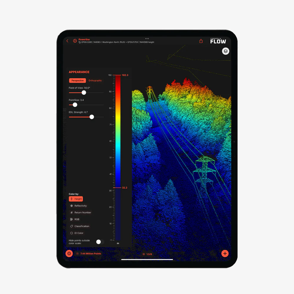
Powered by the Hesai XT-32MX (Hesai 32M) scanner, it delivers 1,920,000 points per second across a full 360°×40.3° field of view at ranges up to 300 m (984 ft), with ±1 cm accuracy and 0.5 cm precision, the tightest figures in the Flux family.
At 715 grams with an integrated Smart Dovetail mount, the H1 connects directly to the Freefly Astro, Astro Max, and Alta X Gen2, and exports georeferenced point clouds to LAS or LAZ through the free Freefly Flow iPad app with no software subscription at any stage.
Key Features and Benefits
- Hesai XT-32MX scanner: 1,920,000 points per second at ranges up to 300 m (984 ft).
- 360°×40.3° field of view: full horizontal sweep with vertical coverage in a single pass.
- ±1 cm accuracy: 0.5 cm precision — the highest accuracy specification in the Flux lineup.
- Three laser returns: data fidelity through complex surfaces and partially obstructed geometry.
- Dual U-blox X20 GNSS: full-band L1/L2/L5/L6 receivers for accurate PPK post-processing.
- Ximea 20MP RGB camera: colorizes point cloud data in the same mission pass.
- 715 g total weight: compact form factor optimized for long endurance and global travel.
- Smart Dovetail mount: tool-free integration with Freefly Astro, Astro Max, and Alta X Gen2.
- LAS and LAZ export: industry-standard output with no software subscription required.
- PPK workflow: free Freefly Flow iPad app processes an eight-minute flight in approximately two minutes.
Where the H1 distinguishes itself within the Flux lineup is in the combination of centimeter-level accuracy and a full 360° horizontal field of view. Three laser returns deliver data fidelity through complex and partially obstructed surfaces, the integrated Ximea 20MP RGB camera colorizes the point cloud in the same flight pass, and the dual U-blox X20 full-band GNSS receivers, covering L1, L2, L5, and L6, provide the PPK correction foundation that centimeter-level results require.
For survey professionals, infrastructure engineers, and mapping teams operating across international projects where accuracy standards are non-negotiable and portability is a mission constraint, the Flux H1 delivers a purpose-built answer in a package that travels as easily as it performs.
Centimeter-Level Accuracy in a Globally Deployable Package
The Flux H1's defining characteristic is its accuracy specification: ±1 cm with 0.5 cm precision, achieved through the Hesai XT-32MX scanner and a dual full-band GNSS receiver architecture that covers all four correction bands required for reliable PPK output.
At 300 m range with a full 360° horizontal sweep and 1.92 million points per second, it collects dense, high-fidelity data across a wide operational envelope — enough range for most survey altitudes, enough point density for detailed structural and terrain capture, and enough accuracy for deliverables that hold up under rigorous professional review.
The zero-subscription data pipeline, processing through the free Freefly Flow app on any Apple M-Series iPad with no cloud dependency, keeps the per-mission cost fixed and the workflow portable, which matters for teams operating across multiple sites, regions, or international jurisdictions where software access cannot be assumed.
Freefly Flux LiDAR Payload Comparison
| Category | Flux O1 | Flux L1 | Flux H1 |
|---|---|---|---|
| Scanner | Ouster OS1 | Livox Avia | Hesai XT-32MX |
| Points / sec | 5,242,880 | 720,000 | 1,920,000 |
| Range | ~200 m | 450 m | 300 m |
| Field of view | 360° × 42.4° | 70° × 77° | 360° × 40.3° |
| Accuracy | ±3 cm | ±5 cm | ±1 cm |
| Precision | 0.5 cm | 2 cm | 0.5 cm |
| Laser returns | 2 | 3 | 3 |
| Weight | 633 g | 715 g | 715 g |
| Scan pattern | Repetitive | Non-repetitive | Repetitive |
| NDAA | Yes | No | No |
| RGB camera | Ximea 20MP | Ximea 20MP | Ximea 20MP |
Compatibility and System Integration
- Freefly Astro: native Smart Dovetail integration; GNSS mounts for Astro included in box.
- Freefly Astro Max: native Smart Dovetail integration; GNSS mounts included in box.
- Freefly Alta X Gen2: compatible with separately sold Freefly GNSS Mount.
- Freefly Flow app: free post-processing app for Apple M-Series iPads; no subscription required.
- Full-band GNSS base station: L1, L2, L5, and L6 required; dual-band will not work.
- NTRIP service: full-band equivalent accepted as base station alternative.
- LAS/LAZ output: compatible with standard survey, GIS, and AEC software platforms.
Applications and Use Cases
- High-accuracy survey and mapping: ±1 cm accuracy meets the tightest professional deliverable standards.
- Infrastructure and structural inspection: 360° FOV and three returns resolve complex geometry completely.
- Global and multi-site survey programs: portable 715 g form factor designed for international deployment.
- AEC and as-built documentation: centimeter precision supports design, verification, and compliance workflows.
- Terrain and topographic mapping: 300 m range and full horizontal sweep cover sites efficiently at altitude.
- Corridor and linear asset inspection: 360° horizontal coverage captures all aspects of linear infrastructure.
- Construction monitoring and earthwork: 0.5 cm precision supports volumetric and progress tracking analysis.
The Flux H1 is built for the operator whose deliverable accuracy requirement is the first constraint that defines payload selection, and for whom portability and a clean, cost-fixed data workflow are the second and third. At ±1 cm accuracy with 0.5 cm precision, a 360° field of view, and 1.92 million points per second processed through a free iPad app, it is the highest-accuracy option in the Flux lineup in a package that travels and deploys as efficiently as it measures.
DSLRPros has supported professional UAV operators across survey, inspection, and infrastructure applications for decades, and the Freefly Flux H1 is the payload for operators who require the tightest accuracy specification the Flux lineup offers without adding software overhead to their workflow.
When you order the Flux H1 through DSLRPros, you get the product expertise and configuration support to align your aircraft, base station, and post-processing setup correctly before the payload ships.
Contact DSLRPros today to discuss your requirements or place your order.
