Let’s face it. It can be overwhelming to sift through all the fine print on all the options on the market when trying to find the right drone to fit your business. Is a quadcopter (or hexacopter? Or even bigger?) the best tool for the job? Or is a fixed-wing drone the way to go? If you need to cover large areas of territory and require on your aircraft staying aloft for a long time (longer than 20-25 minutes), a fixed-wing drone is likely what you need. If you need a drone to just do some scouting or inspect smaller areas of land then standard quadcopter is what you need. Once you’ve settled on a fixed-wing or quadcopter, there are still a myriad of options available. How do you know which one will be the best fit for the work you need done? Here we compare two standout agricultural drones on the market today, the senseFly eBee X, and the Parrot Bluegrass Fields Drone.
The eBee X is produced by senseFly, a subsidiary of Parrot, which makes sense, as Parrot is one of the industry leaders in drones for mapping and agriculture applications. The eBee X is marketed as the “fixed-wing drone for all your mapping needs”, suited to applications from agriculture to surveying to construction to mining. Its adaptability comes in large part from the options of cameras and sensors that can be used on the fixed wing to fit your information gathering needs.
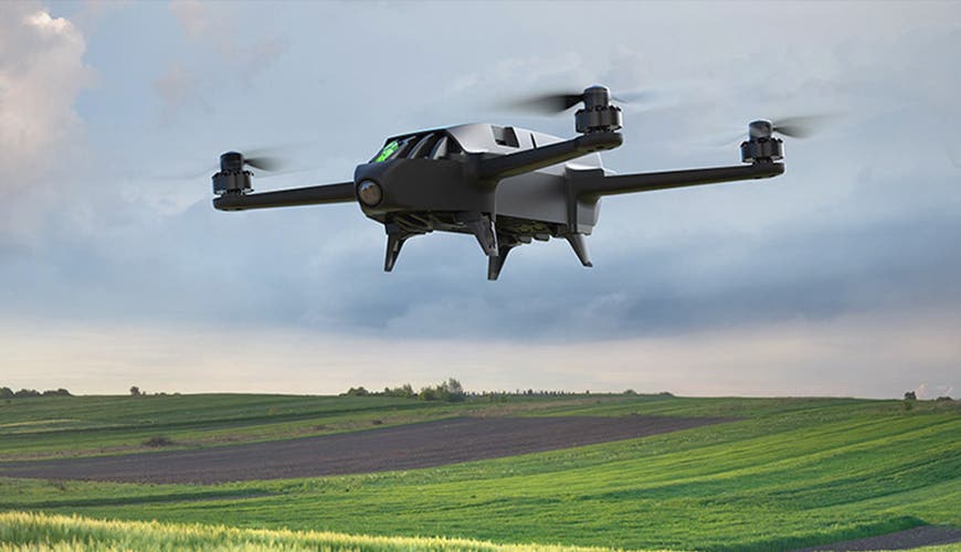
The Parrot Bluegrass Drone, on the other hand, is a more specialized drone, a one-trick pony so to speak, designed primarily for agriculture applications. This is an all-in-one package solution specifically for farmers, taking them from field to data as effortlessly as possible.
Aircraft

The eBee X and the Bluegrass are different in size, due to the wingspan of the eBee X since. The Bluegrass is slightly heavier, weighing in at 4lbs. The eBee X is the lighter of the two, weighing in between 2.2 and 3lbs, depending on the camera and battery. The eBee X is capable of a much longer in-flight time and has removable wings for transport. The eBee X is hand launch for taking off, and has an automatic landing. The mapping route and landing area for the eBee X is user-programmed in before the flight as there is no handheld controller for the fixed wing. Compared to the Bluegrass which can be manually controlled for taking off and landing.
Payload
eBee X
One of the major functional differences between the eBee X and the Bluegrass is the payload options. The eBee X, while not coming equipped with any one standard camera, is much more versatile in its applications because you can add on any of six or more camera/sensor options, each of which is uniquely suited to a specific industry use. The eBee X is compatible with the following payload options:

The senseFly S.O.D.A. was the first camera designed for professional drone photogrammetry and has quickly become the industry standard. It captures amazingly sharp aerial images, across most light conditions. These images are then used to produce detailed, vivid orthomosaics and ultra-accurate 3D digital surface models.
The senseFly S.O.D.A. 3D is one step up from the S.O.D.A. in that it changes orientation during flight to capture three images (2 oblique, 1 nadir) for a much wider field of view. It is compatible with Pix4Dmapper, for quick, robust image processing.
The senseFly Aeria X is a drone photogrammetry powerhouse, with the added advantage of offering outstanding image detail and clarity in almost all light conditions.

The senseFly Duet T (Left Image) is a unique dual-camera thermal mapping setup. It can be used to create geo-accurate thermal maps together with digital surface models quickly and easily.
Parrot Sequoia+ is the smallest, lightest multispectral sensor ever released. It captures images across four defined, visible and non-visible spectral bands, plus RGB imagery, in just one flight.
senseFly Corridor is specialized for mapping of linear infrastructure and sites. This is actually a combination of senseFly S.O.D.A./eMotion software. The camera is housed in portrait position, as a result requiring 30% fewer images to map the same linear route, making it that much easier and faster to acquire and process the images to produce a map.
Bluegrass
The Bluegrass drone comes built in with only one payload option, the Parrot Sequoia. This may seem limiting, until you consider that the Sequoia is optimized for agricultural applications.
Parrot Sequoia – The Parrot Sequoia contains two sensors, multi-spectral and sunshine, to analyze plants’ vitality by capturing the amount of light they absorb and reflect. When oriented downwards, the multispectral sensor captures RGB photos and the light plants reflect in four separate bands: green and red lights and two infrared bands invisible to the human eye. The sensor can also be placed on the drone facing up, to record the intensity of light from the sun. This allows you to perform radiometric calibration to ensure consistent data measurement.
Flight times
In standard configuration, the eBee X is capable of 59 minutes of continuous flight, but with the optional add-on of Endurance Extension, you can attain a maximum flight time of 90 min. With this capability, the eBee X can achieve vast coverage of up to 500 ha (1,235 ac) at an altitude of 120m (400 ft). The Parrot Bluegrass package comes with 3 batteries. Each battery gets 25 minutes of flight time. Cover large fields up to 65 ha (160 ac) at 122 m (400 ft) or fly low for greater resolution of down to 0.9cm/px at 10m (0.35 in/px at 33 ft) – single image.
Special features
eBee X
The eBee X comes with eMotion, a flight planning software program that is user-friendly yet powerful, allowing you to select flight paths, assistance features and other mission planning tools for every application. The eBee X is an autonomous flight drone meaning there is no remote controller. Before the flight on the computer, the user plans the route then launches the drone, the drone will then begin its flight path. Once done it will land where specified on the eMotion software before the flight.
Bluegrass
Flight planning features are also available with the Bluegrass, providing automatic flight planning through the Pix4Dcapture mobile app. Another special feature is that the package deal includes a one-year subscription to ParrotFields mobile app and Pix4Dfiel software agricultural cloud mapping platform. This program will process the data you collect, with up to 50 ha / 123 acres processed in 1.5 minutes. Generate predefined or custom index maps for detailed crop performance and analysis.

Applications
Between its extensive flight capability and the variety in payload options, the senseFly eBee X is well-suited to a range of applications. It is billed as being suitable for surveying & mapping, mining, quarries & aggregates, engineering & construction, agriculture, environmental protection, and humanitarian uses. Businesses in each of these industries can select from the different sensors and cameras to configure the perfect solution to their needs. The Parrot Bluegrass is less versatile and more specialized. Billed as an end-to-end solution, the Parrot Bluegrass makes it easy for farmers to quickly get an insight on the health of their crops, thanks to visual crop scouting and specialized NDVI maps. For the farmer who simply wants a plug-and-play solution, without having to do lots of customization and flight planning, the Parrot Bluegrass may be just the ticket.


