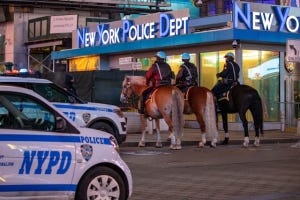
Historically, drones have been used by the military for reconnaissance and combat purposes, but their utility has expanded to public safety applications, including traffic monitoring by police departments.
State agencies began experimenting with drones for such purposes in the mid-2000s. Other tasks included the likes of aerial surveillance to crime scene analysis. In 2020, a report from Minnesota documented the use of drones 1,171 times by 93 law enforcement agencies – integrating them into daily policing tasks beyond just emergency responses.
The Numbers: Drones In Public Safety Agencies By Jurisdiction.
Narrowing down to traffic management, here are some of the departments that have already gone a long way in integrating drones into their operations over the years:
6 Police Departments Using Traffic Drones
1. Chula Vista Police Department (CVPD)
California’s CVPD has been using drones as a transformative tool in law enforcement, particularly in enhancing response times and traffic management since 2015. By deploying drones as first responders, CVPD has been able to quickly evaluate the severity of incidents, such as traffic collisions, allowing for a more efficient allocation of resources to urgent public safety issues. The department aims to bolster police capabilities with airborne support, which in turn, helps to preserve peace, shorten response times, and enhance community life quality.
Central to this initiative was the formation of a UAS Committee in December 2015, dedicated to exploring how drone technology could be applied in ways that maintain public trust and respect civil liberties and privacy rights. This involved engaging with the community through extensive outreach to explain the program and solicit feedback, underscoring a commitment to using drones solely for specific incident responses or investigations rather than general surveillance.
A key milestone in this journey was the launch of the Drone as First Responder (DFR) Program in 2018. Drones are swiftly dispatched to emergency scenes from the department’s HQ, providing immediate situational awareness and potentially improving safety and operational efficiency. By 2021, this capability was expanded city-wide, a move made possible through partnerships and the acquisition of new launch sites and more advanced drones.
2. Washington State Patrol (WSP)
Known to have the largest fleet of drones among law enforcement agencies in the nation, the WSP uses drones for mapping crash scenes among other tasks. Many of the drones, manufactured by DJI Technology, are equipped with cameras and are used to map accident scenes much more quickly and efficiently than traditional methods. Detective Sergeant Clint Thomas of the WSP notes how what used to take three to four hours to map can now be done in as little as 20 minutes. For instance, a simple two-vehicle crash scene can be accurately mapped in just 10 minutes, a task that would typically take even up to an hour with conventional tools like tape measures, chalk, or laser scanners. This rapid mapping is crucial for clearing roadways faster and improving traffic flow after accidents.
The deployment of drones has sparked discussions on privacy and surveillance, with the WSP consulting the American Civil Liberties Union (ACLU) to develop a drone use policy that focuses on specific operational uses like accident reconstruction and potentially wildfire monitoring, while strictly prohibiting surveillance activities. Despite these measures, there remains concern over privacy and the potential for 'mission creep' given the extensive data collection capabilities of drones.
3. Renton Police Department (RDP)
Washington’s RPD has been working with drones to enhance its operations since 2016. The primary application of drones by the RPD has been in mapping crime and traffic accident scenes more efficiently and accurately than traditional methods including walking around with surveyor gear. With drones they can rapidly collect photographic data, which can then be analyzed using photogrammetry software to create detailed 3-D reconstructions of scenes. This not only saves significant time on-site but also provides investigators with millions of data points for analysis, greatly surpassing the level of detail achievable with previous technologies.
The department's UAV program includes two drones equipped with different types of photographic equipment, supporting a wide range of investigative needs. Importantly, the RPD has been proactive in addressing privacy concerns associated with drone usage, developing an internal policy that restricts the drones' use to specific operational purposes such as traffic accidents, crime scenes, and other official law enforcement activities, explicitly excluding random surveillance activities.
The program's initial outlay was about $30,000. This sum covered the expenses for the drones, their cameras, and the required software. The department as this expenditure as worthwhile, given drones' substantial contribution to operational effectiveness. This was coupled with the potential for cost reductions in other departments, like less need for overtime due to expedited investigation processes.
4. Kent Police Department
Kent's drone program is extensive, featuring drones like the DJI Inspire 2 and three DJI Mavic Pro Platinums designated for traffic units. These units are primarily deployed for collision and crime scene mapping, offering a significant advantage in terms of both time and accuracy compared to traditional methods. For instance, drones allow for rapid scene mapping, reducing the time required to gather critical information and thus minimizing road closures and disruptions. Additionally, the department utilizes a DJI Mavic 2 Pro for detective work and another DJI Mavic Pro Platinum equipped with forward-looking infrared for the patrol division, enhancing the capabilities for nighttime and specialized operations.
The implementation of drones also supports K9 units, search and rescue operations, and the management of incidents involving armed suspects or high-risk warrants. Kent Police Department has established strict guidelines to govern the use of drones, emphasizing respect for privacy and ethical considerations. These policies prohibit the filming of private areas where individuals have a reasonable expectation of privacy and mandate that all drone operations be approved by a sergeant or higher-ranking official. Flights are meticulously logged, and video recordings are maintained as public records, ensuring transparency and accountability in drone usage.
5. Tukwila Police Department
Starting back in May 2017, after an extensive training program, a team of eight officers was certified and ready to deploy drones based on a proposed pilot program. These drones have since been used for various purposes, including search and rescue operations, crime and accident scene documentation through 3D mapping, and enhancing officer safety during critical incidents by providing aerial perspectives for better situational awareness.
The department undertook a rigorous process to address privacy concerns and ensure responsible use of drones. This involved adopting strategies and recommendations from organizations like the Department of Justice, the International Association of Chiefs of Police, and the American Civil Liberties Union, focusing on privacy, use authorization, data management, and specific restrictions on drone use. The intent was to communicate transparently with the community and local government about the benefits and regulations surrounding drone use, aiming to gain broad support for the program.
The Tukwila Police Department in Washington has developed an extensive drone (UAS) program aimed at enhancing public safety, protecting property, and accurately documenting crime and collision scenes. Their UAS program, launched after receiving FAA Part 107 UAS Remote Pilot Certificates, includes comprehensive training for police officers. The program's deployment has proven beneficial in SWAT operations, providing aerial perspectives for better situational awareness, and in quickly mapping traffic accident scenes for faster roadway clearance.
6. Oklahoma City Police Department
When the Oklahoma City Police Department (OCPD) began incorporating drones into its operations, there were public concerns regarding transparency and the scope of their use. Questions were raised by city council members about the transparency and evolution of the program's use beyond its initially stated purposes.
Chief of Police Wade Gourley indicated that main uses for the drones would include mapping crime scenes and traffic accidents, with potential future uses for surveillance at large public events. The implementation of drone technology by the OCPD aims to enhance operational efficiency in these areas. There were assurances made that the drones would be used within the framework of existing laws and regulations, including adherence to the Fourth Amendment, to prevent any misuse that could infringe on privacy rights. The cost for the drones and related accessories was estimated at around $75,000, with additional related items and services costing approximately $25,000.
Also Read: Seven Police Departments Spending At Least $20,000 For Their Drone Programs
Benefits of Using Drones for Traffic Monitoring
The traffic management market is projected to grow from $42.3 billion in 2023 to $72.5 billion by 2028. That's a yearly growth rate of 11.4%! Drones take a significant share of this, with more police departments incorporating them into their operations, for the value they bring, including:
- Efficiency and Coverage
Say you're trying to figure out why traffic's backed up on the main bridge across town. From the ground, your view is limited. You can't see beyond the nearest bend. But a drone flies up and gives you a clear picture of the entire situation quickly. Whether it's a breakdown, a minor crash, or just heavy congestion, the drone spots it, and you know exactly what resources to deploy and where.
It could be unusual obstruction or a potential hazard on a less-traveled road. Sending a patrol car could take time, especially if it's out of the way. A drone, however, can be over the scene in minutes, providing live feedback so you can decide without delay if it's a false alarm or if you need to redirect traffic or send a team to handle it.
Even with accident scenes, officers need to get a full scope of the incident as quickly as possible – and UAVs are an asset for this, especially compared to manned patrols that are limited by road conditions and helicopters which need more logistical support to deploy.

- Cost-Effectiveness
Department heads are already in a tight spot when looking at their budgets, trying to make the numbers work for everything from patrols to equipment upgrades. Helicopters - which had previously been the gold standard aerial support in traffic management, have operational costs running into the millions. Regular inspections, repairs, fuel - the costs add up pretty fast.
On the other hand drones might only dent your budget by a few thousand. Charging a battery is always going to be more cost-effective than refueling a helicopter. Plus, drones don't require a highly specialized pilot; with some training, your team can handle it in-house. The UAVs can also launched quickly, provide live video feed directly to your command center, and be redirected on the fly without worrying about refueling or flight time limits – especially when using long-range drones with hot-swap batteries.
- Safety Improvements (for both officers and civilians)
After the enactment of a 2021 state law restricting police pursuits, Washington state saw a more than 80% reduction in vehicular deaths caused by police pursuits, with deaths dropping to two from eleven in a comparable period prior. One of the solutions is using UAVs that departments have adopted to track and apprehend suspects are drones and GPS trackers. Additionally, drones can be deployed to assess dangerous situations from a safe distance, minimizing the risk to officers.
- Real-time Data Collection
The advanced sensors and cameras mounted on the UAVs enables officers using them to collect and stream live footage. This includes real-time data on traffic conditions, accidents, and ongoing pursuits. Coud based solutions enable this data to be relayed to all relevant stakeholders in real-time, for better collaboration and decision making. Moreover, the ability to conduct accident reconstruction through drone mapping and modeling provides accurate assessments of crash scenes, aiding investigations and improving the reliability of determining fault.
Drone Training For Police Traffic Departments
Integrating UAV solutions into your operations has its challenges – especially with getting the officers well adept with the different drones, skills needed to pilot them, as well as handling the integrated software. DSLRPros offers a comprehensive drone training program tailored specifically for professional applications, including traffic and public safety operations. This training is designed to enhance the efficiency and safety of drone operations for police departments, focusing on traffic management and emergency response scenarios.
With courses ranging from basic drone operation to advanced UAS Operator Courses, DSLRPros prepares your team for a variety of situations, including search and rescue, hazmat situations, law enforcement interventions, and more. These classes provide hands-on experience with the latest drone technology, ensuring your team is equipped with the knowledge and skills to utilize drones effectively in your operations. To learn more about it, visit our UAS Operator Training page or contact us via phone on (877) 299-1075 / (213) 262-9436 or email sales@DSLRPros.com.