







MicaSense RedEdge-P and Altum-PT: Calibrated Multispectral and Thermal Payloads for Precision Agriculture and Environmental Remote Sensing
MicaSense payloads are NDAA-compliant aerial imaging sensors designed for quantitative spectral analysis — radiometrically calibrated, factory-verified instruments that produce scientifically accurate reflectance and temperature data rather than visual imagery. DSLRPros carries the full MicaSense lineup: the RedEdge-P and its Blue and Green spectral variants for high-resolution multispectral analysis; the Altum-PT for simultaneous multispectral, panchromatic, and radiometric thermal capture in a single payload; Skyport V2 integration kits for DJI M300/M350 RTK; the Inspired Flight IF800/IF1200 integration kit; calibration accessories including the Calibrated Reflectance Panel 2 and Downwelling Light Sensor 2; and mounting hardware for DJI platforms.
Both payload families share a common design foundation: global shutter sensors across all imaging bands for distortion-free capture during forward flight, synchronized triggering across all spectral bands per capture event, CFexpress removable storage, and fully open data output in 12-bit TIFF and raw DNG for processing in any photogrammetry or remote sensing pipeline. All MicaSense sensors are designed, manufactured, and engineered in the United States. DSLRPros provides pre-sale configuration guidance, integration support, and post-purchase technical assistance for every MicaSense deployment.
RedEdge-P and Altum-PT: Choosing Between the Two Payload Families
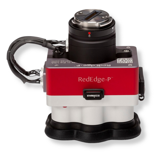
The RedEdge-P is a dedicated multispectral and panchromatic sensor — it captures five spectral bands plus a panchromatic band and produces pan-sharpened multispectral imagery at up to 2 cm/pixel from 60 m altitude. It does not include a thermal sensor. The Altum-PT adds a 320 x 256 FLIR Boson radiometric thermal sensor to the same five spectral bands and a higher-resolution panchromatic imager, enabling simultaneous thermal and multispectral capture in one flight without payload changes. The Altum-PT is heavier, bulkier, and slower in capture rate than the RedEdge-P; the RedEdge-P captures up to 3 frames/second versus the Altum-PT's 2 frames/second, and produces higher multispectral GSD at altitude for programs where thermal data is not needed.
| Specification | Multispectral + Panchromatic RedEdge-P | Multispectral + Thermal + Panchromatic Altum-PT |
|---|---|---|
| Weight (kit with DLS 2) | 300 g (sensor + DLS 2 only) 745 g (dual kit: two sensors, mounting, DLS 2, cable) |
577 g (with Wi-Fi, CFexpress card, DLS 2, cables) |
| Dimensions | 8.2 × 6.2 × 5.4 cm (single sensor) | 11.0 × 8.0 × 6.9 cm |
| Multispectral bands | 5: Blue 475 nm, Green 560 nm, Red 668 nm, Red Edge 717 nm, NIR 842 nm | 5: Blue 475 nm, Green 560 nm, Red 668 nm, Red Edge 717 nm, NIR 842 nm |
| MS sensor resolution | 1456 × 1088 (1.6 MP per band) | 2064 × 1544 (3.2 MP per band) |
| Panchromatic sensor | 2464 × 2056 (5.1 MP) | 4112 × 3008 (12 MP) |
| RGB color output | 5.1 MP (global shutter, aligned) | 12.4 MP (global shutter, aligned) |
| Thermal sensor | None | 320 × 256 FLIR Boson LWIR; 7.5–13.5 µm; radiometrically calibrated |
| MS GSD at 120 m | 7.7 cm/pixel per MS band | 5.28 cm/pixel per MS band |
| Panchromatic GSD at 120 m | 3.98 cm/pixel; 2 cm/pixel pan-sharpened at 60 m | 2.49 cm/pixel; 1.25 cm/pixel pan-sharpened at 60 m |
| Thermal GSD | Not applicable | 33.5 cm/pixel at 120 m; 17 cm/pixel at 60 m |
| Field of view (MS) | 50° H × 38° V | 50° H × 38° V |
| Field of view (PAN) | 44° H × 38° V | 46° H × 35° V |
| Field of view (thermal) | Not applicable | 48° × 39° |
| Capture rate | Up to 3 frames/second (raw DNG) | Up to 2 frames/second (raw DNG) |
| Storage | CFexpress (up to 2 TB) | CFexpress |
| Power input | 7.0–25.2V DC; 10W peak | 7.0–25.2V DC; 10W peak |
| Global shutter | Yes — all bands | Yes — all bands |
| Dual-camera configuration | Yes — pairs with RedEdge-P Blue or RedEdge-P Green for 10-band system | No — standalone only |
| NDAA compliant | Yes — designed and manufactured in USA | Yes — designed and manufactured in USA |
| Primary mission | Precision agriculture, crop health, forestry, environmental monitoring, research trials | Agriculture with thermal stress analysis, irrigation management, combined spectral and thermal remote sensing |
Scroll horizontally to view all specifications. GSD values are ground sample distance measured in controlled conditions at stated altitude.
Sensor Variants, Integration Kits, and Accessories Available at DSLRPros
Sensor configurations:
- MicaSense RedEdge-P: five-band multispectral plus 5.1 MP panchromatic sensor; single-sensor standalone configuration; 300 g sensor with DLS 2; upgradeable to dual-camera system with RedEdge-P Blue or RedEdge-P Green
- MicaSense RedEdge-P Green Multispectral Kit: green-optimized spectral variant for enhanced vegetation and canopy analysis; pairs with RedEdge-P Red for a 10-band dual-camera system
- MicaSense RedEdge-P Blue Multispectral Kit: blue-shifted spectral variant with coastal blue band for aquatic analysis, water body mapping, and extended spectral coverage; pairs with RedEdge-P Red for 10-band system — currently sold out, check DSLRPros for availability
- MicaSense RedEdge-P Dual Multispectral Upgrade Kit: for existing RedEdge-P owners who want to expand to a 10-band dual-camera system; includes second sensor and mounting hardware without duplicate calibration accessories
- MicaSense Altum-PT: five multispectral bands plus 12 MP panchromatic plus 320 x 256 FLIR Boson thermal in a single synchronized payload; 577 g kit weight including DLS 2, Wi-Fi, and CFexpress
DJI integration kits (M300 RTK and M350 RTK Skyport V2 interface):
- MicaSense RedEdge-P Multispectral Camera Kit with DJI Skyport M300/M350: complete bundle of RedEdge-P sensor plus DJI Skyport V2 integration hardware for M300 RTK and M350 RTK
- MicaSense DJI M300/M350 SkyPort Kit for RedEdge-P: Skyport V2 integration hardware sold separately for operators who already own the RedEdge-P sensor
- MicaSense Altum-PT with DJI M300/M350 SkyPort Kit: complete bundle of Altum-PT plus DJI Skyport V2 integration hardware — currently sold out, contact DSLRPros for availability
- MicaSense DJI M300/M350 SkyPort Kit for Altum-PT: Skyport V2 integration hardware sold separately for operators who already own the Altum-PT sensor
Inspired Flight integration:
- Inspired Flight MicaSense Altum-PT and Integration Kit Bundle: Altum-PT plus the purpose-built integration kit for the Inspired Flight IF800 and IF1200 platforms; contact DSLRPros for pricing
Calibration and accessory hardware:
- MicaSense Calibrated Reflectance Panel 2 (CRP 2): white-reference calibration panel for radiometric calibration before and after each flight; required for accurate reflectance-based vegetation index generation; compatible with all current MicaSense sensors
- MicaSense Downwelling Light Sensor 2 (DLS 2): skyward-facing irradiance sensor for in-flight ambient light correction; integrates GPS for geotagging; essential for consistent reflectance output across varying illumination conditions during longer mapping flights
- MicaSense DLS 2 Mount for DJI Matrice 350 RTK: dedicated mounting bracket for the DLS 2 on the M350 RTK airframe, positioning it correctly above the aircraft for unobstructed skyward illumination measurement
- MicaSense Wire Harness Kit for RedEdge-P or Altum-PT to Skyport V2: power and communication wiring for Skyport V2 integration without the full Skyport kit; for operators with existing Skyport hardware adding new or replacement sensors
- MicaSense Gen 3 Quick Mount for DJI Drones: tool-free quick-release mounting system for RedEdge-P and Altum-PT on DJI platforms without Skyport; enables rapid sensor installation and removal between flights
- MicaSense Altum CFExpress Card Reader: USB-C card reader for fast CFexpress data offload from Altum sensor to computer; on sale at DSLRPros
What MicaSense Payloads Capture and Why It Matters
- Calibrated reflectance output: both sensors produce radiometrically calibrated data — each pixel value represents actual surface reflectance rather than raw sensor exposure, making results comparable across flights, dates, and locations without additional correction
- Five narrow spectral bands: Blue (475 nm), Green (560 nm), Red (668 nm), Red Edge (717 nm), and Near-Infrared (842 nm) are captured simultaneously across all sensors; narrowband filters enable vegetation indices (NDVI, NDRE, GNDVI, CIR) that broadband RGB cameras cannot generate accurately
- Red Edge band for early stress detection: the 712–722 nm Red Edge range is where plant stress first appears spectrally; early-stage disease, water stress, and nutrient deficiency show in Red Edge data before visual symptoms are apparent
- Pan-sharpening for enhanced spatial resolution: the high-resolution panchromatic sensor fuses with multispectral bands to produce pan-sharpened outputs at 2 cm/pixel (RedEdge-P at 60 m) or 1.25 cm/pixel (Altum-PT at 60 m) — resolution sufficient for plant counting, phenotyping, and AI/ML classification tasks
- Global shutter across all bands: eliminates rolling shutter distortion during forward flight at mapping speeds; all multispectral, panchromatic, and thermal bands are captured at the same moment
- Synchronized multi-band capture: all spectral bands are triggered simultaneously, eliminating parallax between bands that would otherwise require complex alignment in post-processing
- Thermal measurement (Altum-PT only): the 320 x 256 FLIR Boson sensor provides radiometric temperature measurement aligned with the multispectral bands, enabling combined thermal-spectral analysis in a single pass at 33.5 cm/pixel GSD from 120 m
- Open data architecture: raw 12-bit TIFF and DNG outputs are compatible with Pix4Dfields, Agisoft Metashape, DroneDeploy, QGIS, ArcGIS, and other photogrammetry and GIS platforms without proprietary lock-in
- CFexpress storage: up to 2 TB capacity with up to 3 frames/second write speed on the RedEdge-P, enabling full-day mapping operations before card swap
- NDAA compliance: all MicaSense sensors are designed and manufactured in the United States, meeting NDAA Section 848 requirements for federally funded programs and sensitive operational environments
Where MicaSense Payloads Get Deployed
- Precision agriculture — crop health monitoring: five-band NDVI and NDRE analysis identifies yield-limiting stress, nutrient deficiencies, and disease patches across large fields; repeat flights throughout the growing season track change over time at consistent spectral calibration
- Precision agriculture — plant counting and phenotyping: pan-sharpened outputs at 1.25–2 cm/pixel resolve individual plant canopies for automated counting, early-stage emergence mapping, and stand population analysis at scale
- Irrigation management and water stress detection: Altum-PT thermal sensor detects crop water stress through canopy temperature differentials and identifies irrigation non-uniformity, clogged emitters, and over- or under-irrigated zones
- Fertilizer and nutrient management: Red Edge and NIR bands quantify chlorophyll content and canopy nitrogen status for variable-rate application prescription generation
- Forestry and vegetation analysis: near-infrared and Red Edge bands discriminate tree species and canopy health conditions across forest inventory and monitoring programs
- Environmental monitoring and land management: spectral classification differentiates vegetation communities, invasive species, and land cover types for habitat assessment, restoration monitoring, and conservation programs
- Agricultural research and field trials: factory-calibrated sensors provide the spectral consistency and radiometric accuracy required for replicated experimental designs, variety trials, and multi-site agronomic studies
- 10-band dual-camera programs (RedEdge-P + Blue or Green): 10-spectral-band data aligns with Landsat 8 and Sentinel-2 satellite band sets, enabling drone-to-satellite cross-calibration for large-area monitoring and change detection programs
Compatible Drone Platforms at DSLRPros
MicaSense RedEdge-P and Altum-PT are compatible with the following platforms available at DSLRPros, with integration hardware options listed where applicable:
- DJI Matrice 400: compatible via Gen 3 Quick Mount or Wire Harness Kit; Skyport V2 adapter may be required depending on integration method — confirm with DSLRPros before ordering
- Inspired Flight IF800 and IF1200: Altum-PT integration available via the Inspired Flight MicaSense Altum-PT and Integration Kit Bundle; contact DSLRPros for pricing and RedEdge-P compatibility confirmation
Choosing Between the RedEdge-P and Altum-PT
- Thermal data required: Altum-PT is the only option — the RedEdge-P has no thermal sensor; for any mission requiring canopy temperature measurement, water stress detection, or irrigation analysis, the Altum-PT is the correct payload
- Highest possible multispectral GSD priority: RedEdge-P at 3 frames/second versus Altum-PT at 2 frames/second allows faster flight speeds for the same overlap percentage, covering more area per battery; at the same altitude, RedEdge-P also provides a lighter total system weight
- Maximum multispectral ground resolution: Altum-PT produces 3.2 MP per spectral band versus the RedEdge-P's 1.6 MP per band; for applications requiring fine within-canopy spectral detail (phenotyping, disease scoring, species classification), the Altum-PT's higher MS resolution is the advantage
- 10-band spectral configuration: only the RedEdge-P family supports dual-camera 10-band setups (RedEdge-P + Blue or Green); the Altum-PT has no dual-camera expansion option
- Weight-constrained platform: the RedEdge-P single sensor at 300 g (with DLS 2) is substantially lighter than the Altum-PT at 577 g; for platforms with tight payload weight budgets, the RedEdge-P may be the only viable option
- Satellite data cross-calibration programs: both sensors align with Sentinel-2 and Landsat 8 band sets; the 10-band RedEdge-P dual system adds coastal blue and additional green bands not available on the Altum-PT for programs with satellite correlation requirements
MicaSense RedEdge-P and Altum-PT deliver the spectral precision that separates analytical remote sensing from visual aerial imagery — calibrated, repeatable data that supports management decisions, research conclusions, and regulatory deliverables that RGB-based workflows cannot produce. Both payloads process in standard photogrammetry software with no proprietary pipeline required.
DSLRPros stocks the complete MicaSense lineup including sensor variants, Skyport V2 integration kits, calibration accessories, and platform-specific mounting hardware. Our team provides payload selection guidance, drone compatibility confirmation, and integration support for every MicaSense order. Shop the full MicaSense collection at DSLRPros or contact us for a custom configuration quote.
FAQs
What is the difference between the MicaSense RedEdge-P and the Altum-PT?
The RedEdge-P is a multispectral and panchromatic payload capturing five narrow spectral bands (Blue, Green, Red, Red Edge, NIR) plus a 5.1 MP panchromatic band at up to 3 frames/second. It produces pan-sharpened output at 2 cm/pixel from 60 m and does not include a thermal sensor. The Altum-PT captures the same five spectral bands but at higher multispectral resolution (3.2 MP versus 1.6 MP per band), a higher-resolution 12 MP panchromatic sensor (pan-sharpened 1.25 cm/pixel at 60 m), and adds a 320 x 256 FLIR Boson radiometric thermal sensor for simultaneous thermal and spectral capture. The Altum-PT is heavier (577 g versus 300 g for the RedEdge-P sensor with DLS 2) and captures at up to 2 frames/second rather than 3. If thermal data is not required, the RedEdge-P provides faster area coverage at lower system weight.
What spectral bands do MicaSense payloads capture and what can I do with them?
Both the RedEdge-P and Altum-PT capture five narrow spectral bands simultaneously: Blue (475 nm), Green (560 nm), Red (668 nm), Red Edge (717 nm), and Near-Infrared (842 nm). These bands support standard vegetation indices including NDVI (Normalized Difference Vegetation Index), NDRE (Normalized Difference Red Edge), GNDVI (Green NDVI), and color infrared (CIR) composites. The Red Edge band at 712–722 nm is particularly valuable for early-stage stress detection — plant disease, water stress, and nutrient deficiency appear in the Red Edge spectral response before they become visually apparent in RGB imagery.
What drone platforms are compatible with MicaSense payloads at DSLRPros?
Compatible platforms stocked at DSLRPros include the DJI Matrice 300 RTK and Matrice 350 RTK via Skyport V2 integration kits, the DJI Matrice 400 via the Gen 3 Quick Mount or Wire Harness Kit (confirm integration method with DSLRPros before ordering), and the Inspired Flight IF800 and IF1200 via the dedicated Altum-PT Integration Kit Bundle. The DLS 2 Mount for the Matrice 350 RTK is stocked separately for correct skyward positioning. Contact DSLRPros to confirm platform compatibility before placing an order, particularly for the Matrice 400 and Inspired Flight platforms.
What is the Downwelling Light Sensor 2 (DLS 2) and do I need it?
The DLS 2 is a skyward-facing irradiance sensor that attaches to the aircraft and measures ambient light levels during the flight. It corrects for changing illumination conditions — clouds passing overhead, sun angle variation during long missions, and transitions between shadow and sunlight — to maintain consistent reflectance output across all captured images. Without a DLS 2, reflectance values can vary across a single flight due to illumination changes, reducing the accuracy of vegetation index calculations. The DLS 2 also incorporates a GPS receiver for geotagging. The Calibrated Reflectance Panel 2 is used before and after each flight for pre- and post-flight radiometric calibration; the DLS 2 handles in-flight correction. Both are recommended for quantitative data analysis programs.
What software is compatible with MicaSense data output?
MicaSense sensors output 12-bit TIFF and raw DNG files with embedded metadata. These are compatible with major photogrammetry and remote sensing platforms including Pix4Dfields, Pix4Dmapper, Agisoft Metashape, DroneDeploy, ESRI ArcGIS, QGIS, and others. No proprietary MicaSense software is required for processing — the open data architecture allows operators to choose the processing platform that best fits their workflow or client deliverable requirements.
Can I expand a single RedEdge-P to a 10-band dual-camera system?
Yes. The RedEdge-P can be paired with a RedEdge-P Blue or RedEdge-P Green to create a 10-band dual-camera system. The RedEdge-P Blue adds coastal blue and extended spectral bands optimized for aquatic and water body analysis; the RedEdge-P Green adds green-shifted bands for enhanced canopy discrimination. The RedEdge-P Dual Multispectral Upgrade Kit is available at DSLRPros for existing RedEdge-P owners and includes the second sensor and mounting hardware without duplicating calibration accessories already in the kit. A 10-band configuration aligns with Landsat 8 and Sentinel-2 satellite band sets, enabling drone-to-satellite cross-calibration for large-area monitoring programs.


