


DJI Zenmuse L2 with DSLRPros Care Plus: LiDAR + RGB Imaging with Protection
The DJI Zenmuse L2 combines a frame-based LiDAR module, high-precision IMU, and a 4/3-inch RGB mapping camera on a 3-axis stabilized gimbal. It's engineered for geospatial missions that require both high-density point clouds and color imagery in a single pass. Pairing the L2 with DSLRPros Care Plus adds extended protection against accidental damage and faults-giving you confidence as you collect critical data under field conditions.
Precision Data, Integrated Sensors
The L2 delivers horizontal accuracy of ~5 cm and vertical accuracy of ~4 cm (measured at ~150 m altitude in optimal conditions). It supports both repetitive and non-repetitive scanning modes-repetitive for uniform high-precision mapping, non-repetitive for deeper structural penetration. The payload supports detection up to 450 m at 50% reflectivity or 250 m at 10% reflectivity, and outputs up to 240,000 points/s in single return mode (up to 1,200,000 pts/s in multiple return mode). The RGB camera is a 4/3 CMOS sensor and complements LiDAR data with color capture. The unit is IP54 rated, weighs ~905 ± 5 g, and fits on DJI enterprise platforms including Matrice 300 RTK, 350 RTK, and 400. Operating storage temperature ranges from -20 °C to 60 °C.
Warranty Protection That Covers Real-World Use
DSLRPros Care Plus extends coverage for 13 months from shipment, providing protection beyond DJI's default warranty. The plan covers accidental damage due to pilot error, collisions, drops, water exposure, signal interference, and internal malfunctions. It excludes intentional misuse, theft, cosmetic damage, operations outside manufacturer guidelines, or unauthorized modifications. One replacement is allowed during the coverage term. Claims must be initiated within 7 days of the incident, and the product shipped back in original packaging or equivalent.
Key Features and Benefits
- Comes with DSLRPros Care Plus: 13 months coverage, one replacement for covered damage
- Frame LiDAR + RGB fusion: capture point cloud and color data in one flight
- Horizontal accuracy ~5 cm / Vertical accuracy ~4 cm (at ~150 m)
- Supports repetitive & non-repetitive scanning modes for mapping flexibility
- Detection range up to 450 m @ 50% reflectivity or 250 m @ 10% reflectivity
- Max point cloud rate: 240,000 pts/s (single return), 1,200,000 pts/s (multi)
- 4/3 CMOS RGB camera: color capture for photogrammetric modeling
- IP54 ingress rating: moderate protection from dust and splash
- Weight ~905 g and compact dimensions 155 × 128 × 176 mm
- Compatible with DJI Matrice 300 RTK, 350 RTK, 400 platforms
Applications and Use Cases
- Topographic mapping combining LiDAR and photogrammetry
- Corridor surveys for roads, rails, and pipelines
- Vegetation & forestry structure mapping
- Power line and utility corridor inspection
- Urban modeling integrating elevation and imagery
- Disaster response: mapping damage in complex terrain
- Cultural and heritage surveys with structural detail
- Construction site monitoring with detailed 3D data
- Environmental / terrain change detection
- 3D modeling for planning and integration in GIS
The DJI Zenmuse L2 with DSLRPros Care Plus delivers high-accuracy LiDAR and RGB capabilities in a single payload-backed by protection against the unpredictable. It's ideal for professionals who depend on integrated geospatial data and want coverage for real-world risk.
DSLRPros offers full support-training, maintenance, claims handling, and system consulting. Contact us to configure your L2 + Care Plus bundle and enable your protection coverage.
Specifications
- Product Name: Zenmuse L2
- Dimensions: 155×128×176 mm (L×W×H)
- Weight: 905±5 g
- Power: 28 W (typical), 58 W (max.)
- IP Rating: IP54
- Supported Aircraft: Matrice 300 RTK (requires DJI RC Plus), Matrice 350 RTK
- Storage Temperature: -20° to 60° C (-4° to 140° F)
System Performance
- Detection Range: 450m @50% reflectivity, 0 klx; 250m @10% reflectivity, 100 klx
- Point Cloud Rate: Single return: max. 240,000 pts/s; Multiple returns: max. 1,200,000 pts/s
- System Accuracy: Horizontal: 5 cm @ 150 m; Vertical: 4 cm @ 150 m
- Real-Time Point Cloud Coloring: Reflectivity, Height, Distance, RGB
LiDAR
- Ranging Accuracy: 2 cm @ 150 m
- Maximum Returns: 5
- Scanning Modes: Non-repetitive, Repetitive
- FOV: Repetitive: Horizontal 70°, Vertical 3°; Non-repetitive: Horizontal 70°, Vertical 75°
- Minimum Detection Range: 3 m
- Laser Beam Divergence: Horizontal 0.2 mrad, Vertical 0.6 mrad
- Laser Wavelength: 905 nm
- Laser Spot Size: Horizontal 4 cm, Vertical 12 cm @ 100 m
- Laser Frequency: 240 kHz
- Laser Safety: Class 1 (IEC 60825-1:2014)
- Max Laser Pulse Power: 46.718 W
Inertial Navigation
- IMU Frequency: 200 Hz
- Accelerometer Range: ±6 g
- Yaw Accuracy: Real-time: 0.2°, Post-processing: 0.05°
- Pitch/Roll Accuracy: Real-time: 0.05°, Post-processing: 0.025°
- Horizontal Position Accuracy: RTK FIX: 1 cm + 1 ppm
- Vertical Position Accuracy: RTK FIX: 1.5 cm + 1 ppm
RGB Mapping Camera
- Sensor: 4/3 CMOS, Effective Pixels: 20 MP
- Lens: FOV: 84°, Format Equivalent: 24 mm, Aperture: f/2.8-f/11
- Shutter Speed: Mechanical: 2-1/2000 s, Electronic: 2-1/8000 s
- Photo Size: 5280×3956 (4:3)
- Video Resolution: 4K: 3840×2160@30fps, FHD: 1920×1080@30fps
- ISO: 100-6400
- Supported Formats: Photo: JPEG/DNG; Video: MP4
Gimbal
- Stabilization: 3-axis (tilt, roll, pan)
- Angular Vibration: ±0.01°
- Controllable Range: Tilt: -120° to +30°, Pan: ±90°
Data Storage
- Raw Data: Photo, IMU, Point Cloud, GNSS
- Supported microSD: UHS-I Speed Grade 3, Max 256 GB
Post-Processing
- Software: DJI Terra
-
Data Formats: PNTS, LAS, PLY, PCD, S3MB
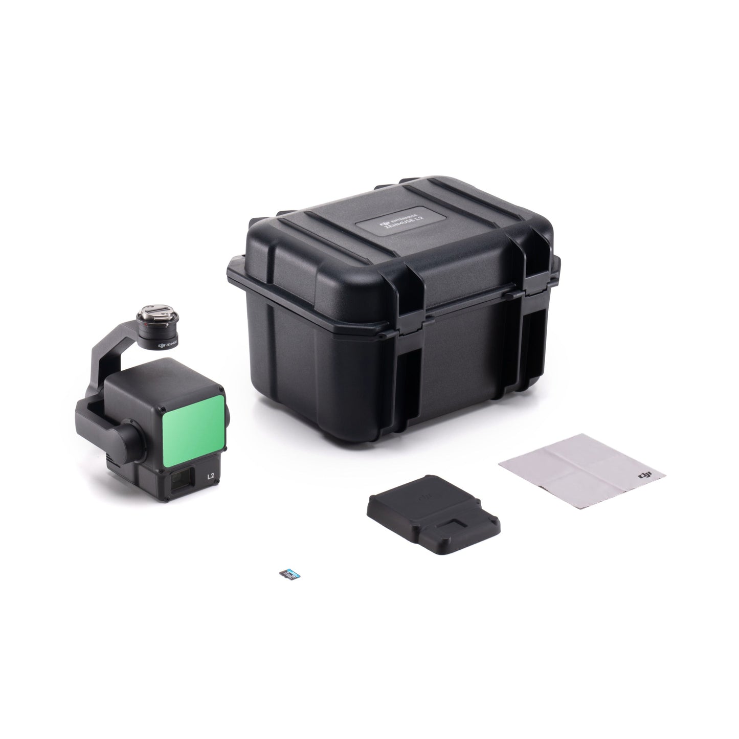
In the Box
- 1x DJI Zenmuse L2
- 1x MicroSD Card (128GB)
- 1x Lens Cap
- 1x Storage Case
- 1x Lens Cleaning Cloth
- 1x DSLRPros Care Plus (Zenmuse L2)
