
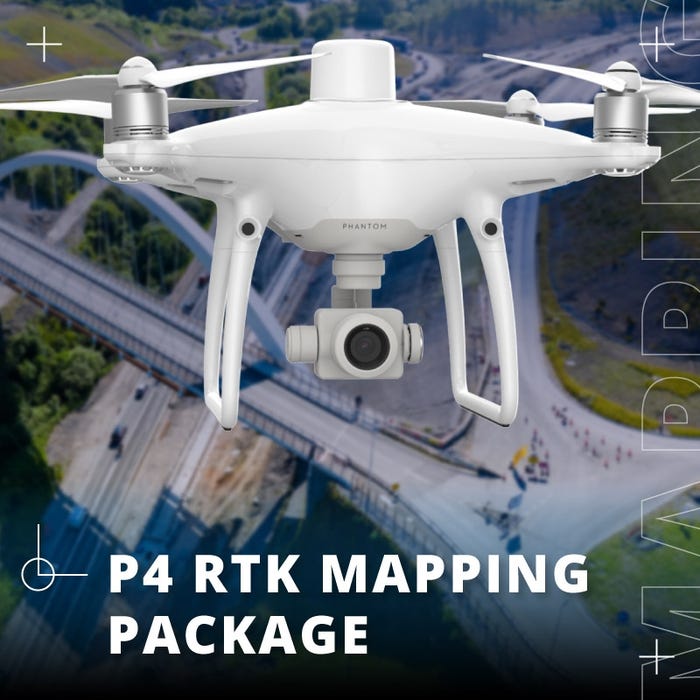
Phantom 4 RTK Professional Mapping Package
Vendor Part Number
B-NB-P4RB
- Everything you need to get reliable, accurate results
- Map up to 3mi² without needing to recharge batteries
- Includes DJI Care Enterprise
- Includes GPC water and dust-proof case
- Up to 2 cm relative vertical accuracy
- Up to 1.20 cm relative horizontal accuracy
- High accuracy with few to no GCPs
- Meets requirements for ASPRS Accuracy Standards for Digital Orthophotos Class Ⅲ
OR

Visionary Intelligence. Elevated Accuracy.
DJI has rethought its drone technology from the ground-up, revolutionizing its systems to achieve a new standard for drone accuracy — offering Phantom 4 RTK customers centimeter-accurate data while requiring fewer ground control points.
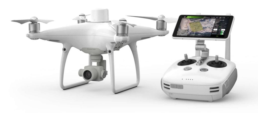
Centimeter Level Positioning System
A new RTK module is integrated directly into the Phantom 4 RTK, providing real-time, centimeter-level positioning data for improved absolute accuracy on image metadata. Sitting just beneath the RTK receiver is a redundant GNSS module, installed to maintain flight stability in signal-poor regions such as dense cities. Combining both modules, the Phantom 4 RTK is able to optimize flight safety while ensuring the most precise data is captured for complex surveying, mapping and inspection workflows.
Fit the Phantom 4 RTK to any workflow, with the ability to connect this positioning system to the D-RTK 2 Mobile Station, NTRIP (Network Transport of RTCM via Internet Protocol) using a 4G dongle or WiFi hotspot, or store the satellite observation data to be used for Post Processed Kinematics (PPK).
Gather Accurate Data with TimeSync
To take full advantage of the Phantom 4 RTK's positioning modules, the new TimeSync system was created to continually align the flight controller, camera and RTK module. Additionally, TimeSync ensures each photo uses the most accurate metadata and fixes the positioning data to the center of the CMOS — optimizing the results from photogrammetric methods and letting the image achieve centimeter-level positioning data.

Precise Imaging System
Capture the best image data with a 1-inch, 20 megapixel CMOS sensor. The mechanical shutter makes mapping missions or regular data capture seamless as the Phantom 4 RTK can move while taking pictures without the risk of rolling shutter blur. Due to the high resolution, the Phantom 4 RTK can achieve a Ground Sample Distance (GSD) of 2.74 cm at 100 meters flight altitude. To ensure each Phantom 4 RTK offers unparalleled accuracy, every single camera lens goes through a rigorous calibration process where radial and tangential lens distortions are measured. The distortion parameters gathered are saved into each image's metadata, letting post-processing software adjust uniquely for every user.
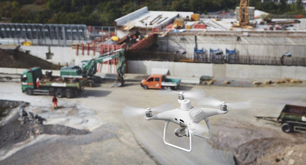
NEXT GENERATION MAPPING —SAVING TIME IN CONSTRUCTION SURVEYING WITH DRONES
To match the growing demand for improved transportation infrastructure, Teams have seen towards new technologies to increase efficiency. Throughout that process, many contractors have put drones to use on Site to create regular site maps and conduct surveying missions faster.
"The use of drones for construction mapping has a lot of Advantages. Their integration changes our workflow and Simplifies many operational steps. Conventional surveying Methods do deliver 3D models as well, but digital terrain Model created from drone data provide a higher point Density, and therefore reality is portrayed in much higher Detail", says Thomas Groeninger, Head of Business Unit Digital Object Survey and UAV at STRABAG.
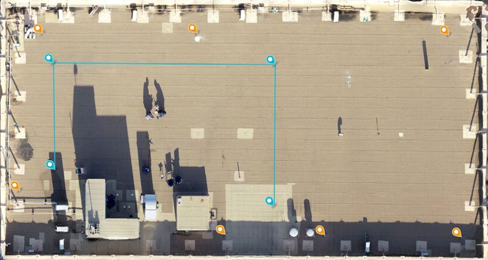
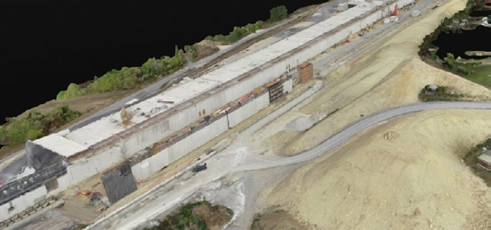
Measurement Accuracy of the DJI Phantom 4 RTK & Photogrammetry
Photogrammetry is not a new science and has been used for topographic mapping, architecture, and engineering long before the advent of drones. But the rise of computer vision-driven photogrammetry in recent years has paralleled the development of accessible commercial drone hardware and software. The simplicity and automation of today's solutions allow professionals to integrate these flying robots into existing workflows to map huge swaths of land and generate high-resolution 3D models. This data makes it possible to analyze the world around us more accurately and quickly than traditional measurement methods, such as ground surveys and manual measurements. In our last white paper, we showed drones can deliver accuracy within 1% of real-world measurements when using Ground Control Points (GCPs).
Click Here for DJI & DroneDeploy's whitepaper on the measurement accuracy of the Phantom 4 RTK. (Link opens in new tab)
Includes DJI Care Enterprise Basic
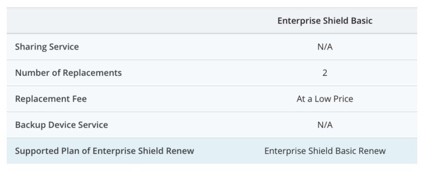
DJI Care Enterprise is a service plan specially designed for DJI Enterprise drones. Providing complete accidental coverage and premium protection options that allow unlimited drone replacements - DJI Care Enterprise offers the most comprehensive reassured flying experience ever developed specifically for the needs of commercial drone fleets. DJI Care Enterprise allows you to fly with peace of mind and focus on the task at hand.
AIRCRAFT
- Takeoff Weight: 1391 g
- Diagonal Distance: 350 mm
- Max Service Ceiling Above Sea Leve:l 19685 ft (6000 m)
- Max Ascent Speed: 6 m/s (automatic flight); 5 m/s (manual control)
- Max Descent Speed: 3 m/s
- Max Speed: 31 mph (50 kph)(P-mode) -- 36 mph (58 kph)(A-mode)
- Max Flight Time: Approx. 30 minutes
- Operating Temperature Range: 32° to 104° F (0° to 40℃)
- Operating Frequency: 2.400 GHz to 2.483 GHz (Europe, Japan, Korea) -- 5.725 GHz to 5.850 GHz (United States, China)
- Transmission Power (EIRP): 2.4 GHz CE (Europe) / MIC (Japan) / KCC (Korea) :< 20 dBm -- 5.8 GHz SRRC(China) / FCC(United States)/NCC(Taiwan,China):< 26 dBm
- Hover Accuracy Range: RTK enabled and functioning properly:Vertical:±0.1 m;Horizontal:±0.1 m -- RTK disabled: Vertical:±0.1 m(with vision positioning );±0.5 m(with GNSS positioning)Horizontal:±0.3 m(with vision positioning); ±1.5 m(with GNSS positioning)
- Image Position Offset: The position of the camera center is relative to the phase center of the onboard D-RTK antenna under the aircraft body's axis:(36, 0, and 192 mm) already applied to the image coordinates in Exif data. The positive x, y, and z axes of the aircraft body point to the forward, rightward, and downward of the aircraft, respectively.
MAPPING FUNCTIONS
- Mapping Accuracy **: Mapping accuracy meets the requirements of the ASPRS Accuracy Standards for Digital Orthophotos Class Ⅲ.
** The actual accuracy depends on surrounding lighting and patterns, aircraft altitude, mapping software used, and other factors when shooting. - Ground Sample Distance(GSD): (H/36.5) cm/pixel,H means the aircraft altitude relative to shooting scene (unit: m)
- Data Acquisition Efficiency: Max operating area of approx. 1 km² for a single flight(at an altitude of 182 m, i.e., GSD is approx. 5 cm/pixel, meeting the requirements of the ASPRS Accuracy Standards for Digital Orthophotos Class Ⅲ
VISION SYSTEM
- Velocity Range: ≤31 mph(50 kph) at 6.6 ft(2 m) above ground with adequate lighting
- Altitude Range: 0-33 ft(0 - 10 m)
- Operating Range: 0-33 ft(0 - 10 m)
- Obstacle Sensing Range: 2-98 ft(0.7-30 m)
- FOV: Forward/Rear: 60° (horizontal), ±27° (vertical) -- Downward: 70° (front and rear), 50° (left and right)
- Measuring Frequency: Forward/Rear:10 Hz -- Downward: 20 Hz
- Operating Environment: Surfaces with clear patterns and adequate lighting(> 15 lux)
CAMERA
- Sensor: 1" CMOS; Effective pixels: 20 M
- Lens: FOV 84°;8.8 mm / 24 mm(35 mm format equivalent:24 mm -- f/2.8 - f/11, auto focus at 1 m - ∞
- ISO Range: Video:100-3200(Auto), 100-6400(Manual) -- Photo:100-3200(Auto), 100-12800(Manual)
- Mechanical Shutter Speed: 8 - 1/2000 s
- Electronic Shutter Speed: 8 - 1/8000 s
- Max Image Size: 4864×3648(4:3)-- 5472×3648(3:2)
- Video Recording Modes: H.264,4K:3840×2160 30p
- Photo Format: JPEG
- Video Format: MOV
- Supported File Systems: FAT32(≤ 32 GB)-- exFAT(> 32 GB)
- Supported SD Cards: MicroSD, Max Capacity: 128 GB. Class 10 or UHS-1 rating required Write speed≥15 MB/s
- Operating Temperature Range: 32° to 104° F (0° to 40℃)
INTELLIGENT FLIGHT BATTERY(PH4-5870MAH-15.2V)
- Capacity: 5870 mAh
- Voltage: 15.2 V
- Battery Type: LiPo 4S
- Energy: 89.2 Wh
- Net Weight: 468 g
- Charging Temperature Range: 14° to 104℉(-10° to 40℃)
- Max charging Power: 160 W
INTELLIGENT BATTERY CHARING HUB(WCH2)
- Input Voltage: 17.3 - 26.2 V
- Output Voltage and Current: 8.7 V,6 A;5 V,2 A
- Operating Temperature: 41° to 104℉(5° to 40℃)
GNSS
- Single-Frequency, High-Sensitivity GNSS Module: GPS+BeiDou+Galileo(Asia) -- GPS+GLONASS+Galileo(other regions)
- Multi-Frequency Multi-System High-Precision RTK GNSS - Frequency Used: GPS:L1/L2-- GLONASS:L1/L2 -- BeiDou:B1/B2 -- Galileo:E1/E5a
- First-Fixed Time:< 50 s
- Positioning Accuracy: Vertical 1.5 cm + 1 ppm(RMS)-- Horizontal 1 cm + 1 ppm(RMS)[1 ppm means the error has a 1mm increase for every 1 km of movement from the aircraft.]
GIMBAL
- Stabilization: 3-axis (tilt, roll, yaw)
- Pitch: -90° to +30°
- Max Controllable Angular Speed: 90°/s
- Angular Vibration Range: ±0.02°
INFRARED
- Obstacle Sensing Range: 0.6-23 ft(0.2 - 7 m)
- FOV: 70°(Horizontal) -- ±10°(Vertical)
- Measuring Frequency: 10 Hz
- Operating Environment: Surface with diffuse reflection material, and reflectivity> 8%(such as wall,trees, humans, etc.)
REMOTE CONTROLLER
- Operating Frequency: 2.400 GHz-2.483 GHz(Europe,Japan,Korea) -- 5.725 GHz-5.850 GHz(United States, China)
- Transmission Power (EIRP): 2.4 GHz CE / MIC / KCC:< 20 dBm -- 5.8 GHz SRRC / FCC:< 26 dBm
- Max Transmission Distance: FCC:4.3 mi(7 km) -- SRRC / CE / MIC / KCC:3.1 mi(5 km) (Unobstrcted, free of interference)
- Power Consumption: 16 W(typical value)
- Display: 5.5 inch screen, 1920×1080, 1000 cd/m², Android System -- Memory 4G RAM+16G ROM
- Operating Temperature Range: 32° to 104° F (0° to 40℃)
INTELLIGENT FLIGHT BATTERY CHARGING HUB(PHANTOM 4 CHARGING HUB)
- Voltage: 17.5 V
- Operating Temperature Range: 41° to 104℉(5° to 40℃)
- Capacity: 4920 mAh
- Voltage: 7.6 V
- Battery Type: LiPo 2S
- Energy: 37.39 Wh
- Operating Temperature: -4° to 104℉(-20° to 40℃)
AC POWER ADAPTER(PH4C160)
- Voltage: 17.4 V
- Rated Power: 160 W

- 1x Phantom 4 RTK
- 1x D-RTK 2 Mobile Station & Tripod
- 1x (Year) DJI Care Enterprise
- 1x Phantom 4 RTK Remote Controller with built-in screen
- 1x GPC Phantom 4 RTK w/ D-RTK 2GroundStation Case
- 1x GPC D-RTK 2 Tripod Bag
- 5x (Total) Phantom 4 Intelligent Flight Battery
- 3x Phantom 4 RTK Remote Controller / D-RTK 2 Mobile Station Battery
- 2x WB37 Battery Charging Hub
- 6x (Total) Pair Propellers
- 1x Battery Charger
- 1x Battery Charging Hub
- 1x MicroUSB Cable
- 1x MicroSD Card
- 1x Gimbal Clamp
Top customer reviews
No reviews
Write Your Own Review