Skip to product information
1 of 4

Terra Xross 1 Indoor Inspection Drone

Terra Xross 1 Indoor Inspection Drone

Regular price $23,980.00
Regular price Sale price $23,980.00
Sale Sold out
Shipping calculated at checkout.

SKU:S-TERRA-XROSS-1

  • Japan-made GNSS-free indoor drone for dark, dusty, and confined space inspections.
  • LiDAR and visual odometry sensors maintain stable position without GPS input.
  • 4K 180° tilt camera with integrated LED illumination for low-light inspection footage.
  • Class 1 LiDAR at 200,000 points per second with 2 cm precision at 10 m.
  • Real-time 3D point cloud view enables safe BVLOS navigation around obstacles.
  • LiDAR range up to 70 m for detection across varied indoor surface reflectivity.
  • Three 5,200 mAh batteries included for back-to-back inspection flight operations.
  • Terra Xross Cloud associates images and video with 3D data for team sharing.
  • Complete system in box: aircraft, controller, tablet, charger, spare props, accessories.
  • Designed to cost roughly one-third of comparable indoor inspection platforms.
View full details
  • Description
  • Specifications
  • In the Box
  • FAQ

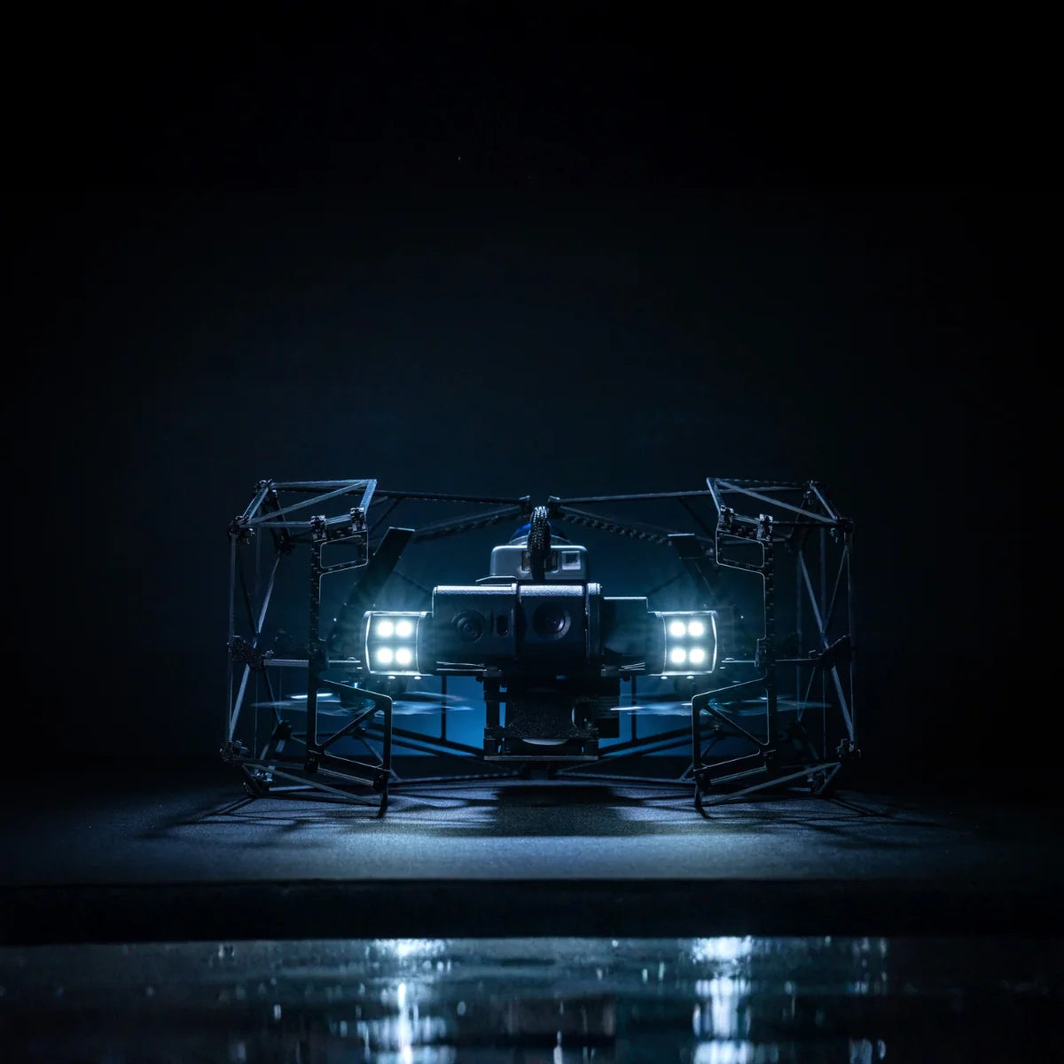
Terra Xross 1: Japan-Made GNSS-Free Indoor Inspection Drone With LiDAR Stabilization and 4K 180° Tilt Camera

The Terra Xross 1 is a purpose-built indoor inspection drone designed for the environments that outdoor platforms cannot enter and conventional inspection methods cannot safely navigate. Dark, dusty, confined spaces where GPS is unavailable and stable flight depends entirely on onboard sensing.

Developed and manufactured in Japan by Terra Drone Corporation, it achieves automatic position correction through a combination of LiDAR and visual odometry sensors, maintaining stable hover and controlled flight without any GNSS input.

A 4K camera with 180° vertical tilt and integrated LED illumination captures clear footage in low-light conditions, and real-time 3D LiDAR data provides situational awareness for safe BVLOS navigation around obstacles.

Engineered specifically to broaden access to indoor drone inspection capability, it is designed to be within reach of operators and programs that existing indoor platforms have priced out.

Key Features and Benefits

  • GNSS-free stabilization: LiDAR and visual odometry sensors maintain position in dark, dusty, cramped spaces.
  • 4K 180° tilt camera: captures high-resolution footage at any angle with integrated LED illumination.
  • Class 1 LiDAR: 200,000 points per second at 10 Hz for real-time 3D data and obstacle awareness.
  • 70 m LiDAR range: 40 m at 10% reflectivity; 70 m at 80% reflectivity for varied surface detection.
  • 2 cm range precision: accurate environmental sensing at 10 m for tight confined space navigation.
  • Real-time 3D view: live point cloud data supports safe BVLOS navigation during indoor flights.
  • Three batteries included: three 5,200 mAh batteries in the box for back-to-back inspection runs.
  • Terra Xross Cloud: associates images and video with 3D data for team collaboration and sharing.
  • Complete system in box: aircraft, controller, tablet, charger, spare props, and accessories included.
  • Made in Japan: in-house developed and manufactured by Terra Drone Corporation.

The Terra Xross 1 ships as a complete, field-ready system: aircraft, controller, three batteries, tablet with holder and cover, charger, spare propellers, battery checker, and a full set of maintenance and connection accessories in the box.

Terra Xross Cloud, launched simultaneously with the aircraft, associates captured images and video with 3D point cloud data for intuitive post-flight visualization, team collaboration, and customer data sharing. 

The LiDAR sensor generates 200,000 points per second at a 10 Hz frame rate with 2 cm range precision at 10 m, supporting both inspection documentation and 3D mapping workflows.

For inspection programs in oil and gas, mining, utilities, maritime, and industrial facilities where workers currently enter dangerous confined spaces to do visual checks that a drone can perform more safely, the Terra Xross 1 represents a practical and immediate path to removing people from harm.

LiDAR Stabilization Built for the Conditions Indoor Inspections Actually Present

The Terra Xross 1's position stabilization system addresses a specific failure mode that affects indoor drones relying solely on visual odometry. In dark, dusty, or featureless environments, cameras lose the visual references needed to track position and the aircraft becomes unstable.

The Terra Xross 1's LiDAR sensor estimates position based on displacement, measuring changes in the physical environment around the aircraft rather than relying on visual contrast, which maintains stable hover and controlled flight even when dust obscures the camera feed or lighting conditions are insufficient for visual tracking.

The same LiDAR data that stabilizes the aircraft is streamed in real time as a 3D point cloud, giving the operator situational awareness of the surrounding geometry during BVLOS flight.

For inspection programs in tanks, boilers, chimneys, ship holds, and underground structures where all of these challenging conditions routinely occur simultaneously, this sensing architecture is the difference between a drone that can reliably complete the mission and one that cannot.

Compatibility and System Integration

  • Terra Xross Cloud: cloud-based platform for 3D point cloud and video data management and sharing.
  • Included tablet: pre-connected tablet with holder, cover, and charging cable for controller interface.
  • Controller: 536 g dedicated controller with cable for tablet connection; included in box.
  • Three 5,200 mAh batteries: 18.5V LiPo, 1-hour charge time; all three included in box.
  • Battery checker: included for pre-flight battery health verification.
  • Spare propeller set: full four-piece spare set included for field maintenance.

Applications and Use Cases

  • Oil and gas plant inspection: stable GNSS-free flight in confined vessels, columns, and elevated structures.
  • Tank and boiler inspection: 4K imagery and LiDAR mapping in enclosed, low-visibility industrial environments.
  • Ship inspection: access confined hull spaces and cargo holds without personnel entry.
  • Chimney inspection: vertical 180° camera tilt captures internal surfaces during ascent and descent.
  • Underground mine mapping: real-time 3D LiDAR data supports excavation planning and structural assessment.
  • Disaster site assessment: navigate collapsed building interiors where human entry is unsafe.
  • Security monitoring: interior surveillance of government and public buildings without physical access.

The Terra Xross 1 exists because the two primary barriers to indoor drone adoption, instability without GPS and prohibitive cost, have consistently blocked operators who could benefit from the technology.

By combining LiDAR-based stabilization with a complete out-of-the-box system, it removes both barriers at once. For inspection programs that have been waiting for an indoor drone that works reliably in the conditions their sites actually present, the Terra Xross 1 is the platform that delivers it.

DSLRPros has supported professional UAV operators across inspection, public safety, and industrial applications for decades, and the Terra Xross 1 is the indoor inspection platform that fills a capability gap that outdoor drones simply cannot address.

When you order the Terra Xross 1 through DSLRPros, you receive the complete system with the product knowledge and deployment support to put it to work in your specific inspection environment from day one.

Contact DSLRPros today to discuss your requirements and place your order.

Aircraft

  • Size: Width 36 cm, Depth 31 cm, Height 21 cm
  • Weight: 1800 g (including battery)
  • Flight time: 10 minutes
  • Max flight speed: 2.5 m/s
  • Wind resistance: 3 m/s
  • Operating temperature: 0°C to 45°C
  • Operating frequency: 2.4 GHz ISM

Camera

  • Sensor: 1/1.7-inch, 8 MP
  • Video resolution: 4K (3840 × 2160)
  • Control mode: Auto mode
  • White balance: Auto

LiDAR

  • Laser safety: Class 1
  • Range: 40 m @ 10% reflectivity
  • Range: 70 m @ 80% reflectivity
  • Range precision: 2 cm @ 10 m
  • Point rate: 200,000 points/s
  • Frame rate: 10 Hz

Light

  • Light output: 10,480 lumens (max)
  • 1x Aircraft
  • 1x Controller
  • 3x Batteries
  • 1x Battery Charger with Cable
  • 1x Controller Charging Cable
  • 1x Controller Strap
  • 1x Controller-to-Tablet Connection Cable
  • 1x Tablet
  • 1x Tablet Charging Cable
  • 1x Tablet Holder
  • 1x Tablet Cover
  • 1x Battery Checker
  • 2x Battery Conversion Plug
  • 1x Nippers and Cable Ties
  • 1x Hexagonal Wrench for Propeller Installation/Removal
  • 1x Lens Cleaning Pen
  • 1x Spare Propeller Set (4 Pieces)
  • 1x Cleaning Cloth
  • 1x Blower
What is the Terra Xross 1 and what type of environments is it designed for?

The Terra Xross 1 is a GNSS-free indoor inspection drone designed and manufactured in Japan by Terra Drone Corporation for use in dark, dusty, and confined spaces where GPS is unavailable and outdoor drones cannot operate.

It maintains stable flight through a combination of LiDAR and visual odometry sensors that estimate position based on displacement rather than visual references, enabling reliable hover and controlled navigation in tanks, boilers, chimneys, ship holds, underground mines, and other enclosed industrial structures.

A 4K camera with 180° vertical tilt and integrated LED illumination captures clear inspection footage, and real-time 3D LiDAR data supports safe BVLOS navigation throughout the mission.

How does the Terra Xross 1 maintain stability without GPS?

The Terra Xross 1 uses a dual-sensor positioning system combining LiDAR and visual odometry. Visual odometry sensors track position using camera-based pattern recognition, but they struggle in dark, featureless, or dusty environments where visual contrast is insufficient.

The Terra Xross 1's LiDAR sensor addresses this by estimating position based on physical displacement, measuring changes in the surrounding geometry rather than relying on visual data.

This allows the aircraft to maintain stable hover and controlled flight even when the camera feed is obscured by dust or inadequate lighting. The same LiDAR data is simultaneously streamed as a real-time 3D point cloud, giving the operator situational awareness of the surrounding environment during flight.

What does the Terra Xross 1 include in the box?

The Terra Xross 1 ships as a complete, field-ready system including the aircraft, dedicated controller, three 5,200 mAh batteries, battery charger and cable, controller charging cable, controller strap, tablet with holder and cover, tablet charging cable, cable for connecting the controller and tablet, battery checker, two battery conversion plugs, nippers and cable ties, hexagonal wrench for propeller removal and attachment, lens cleaning pen, spare propeller set of four pieces, cleaning cloth, and blower. The tablet comes pre-connected and ready for use as the flight display interface. No additional hardware purchases are required for immediate indoor inspection deployment.

What is Terra Xross Cloud and is it required to use the drone?

Terra Xross Cloud is a cloud-based data management platform launched alongside the Terra Xross 1 that associates captured inspection images and videos with the 3D point cloud data collected during the flight. It enables operators to visualize inspection data in 3D space, share data with team members, and deliver results to clients directly through the platform.

Terra Xross Cloud is not required to fly the drone. The aircraft operates independently of the cloud platform during the mission, but it is the recommended workflow for post-flight data management, team collaboration, and professional inspection reporting.

What is the LiDAR sensor's performance and what does it capture?

The Terra Xross 1's Class 1 eye-safe LiDAR generates 200,000 points per second at a 10 Hz frame rate with 2 cm range precision at 10 m. It has a range of 40 m at 10% surface reflectivity and 70 m at 80% reflectivity, covering a wide range of indoor surface materials and conditions.

During flight, the LiDAR simultaneously performs two functions: it provides position data to the flight control system for stable GNSS-free hover, and it streams real-time 3D point cloud data to the operator's display for situational awareness and BVLOS navigation. Post-flight, the 3D data is uploaded to Terra Xross Cloud and associated with the camera footage for comprehensive inspection documentation.

What industries and applications is the Terra Xross 1 suited for?

The Terra Xross 1 is designed for any inspection or mapping application requiring access to enclosed, GPS-denied environments. Confirmed applications include oil and gas plant inspection, tank and boiler inspection, ship hold inspection, chimney inspection, underground mine 3D mapping for excavation planning, disaster site assessment in collapsed structures, and security monitoring inside government and public buildings.

Terra Drone has completed over 1,500 inspection projects globally including work in the FPSO sector. DSLRPros can advise on deployment planning for your specific inspection environment and application.