


MicaSense Altum-PT with DJI M300/M350 SkyPort Kit
MicaSense Altum-PT with DJI M300/M350 SkyPort Kit
SKU:B-MICA-ALT-PT-SKY-M300


- Description
- Specifications
- In the Box
- FAQ
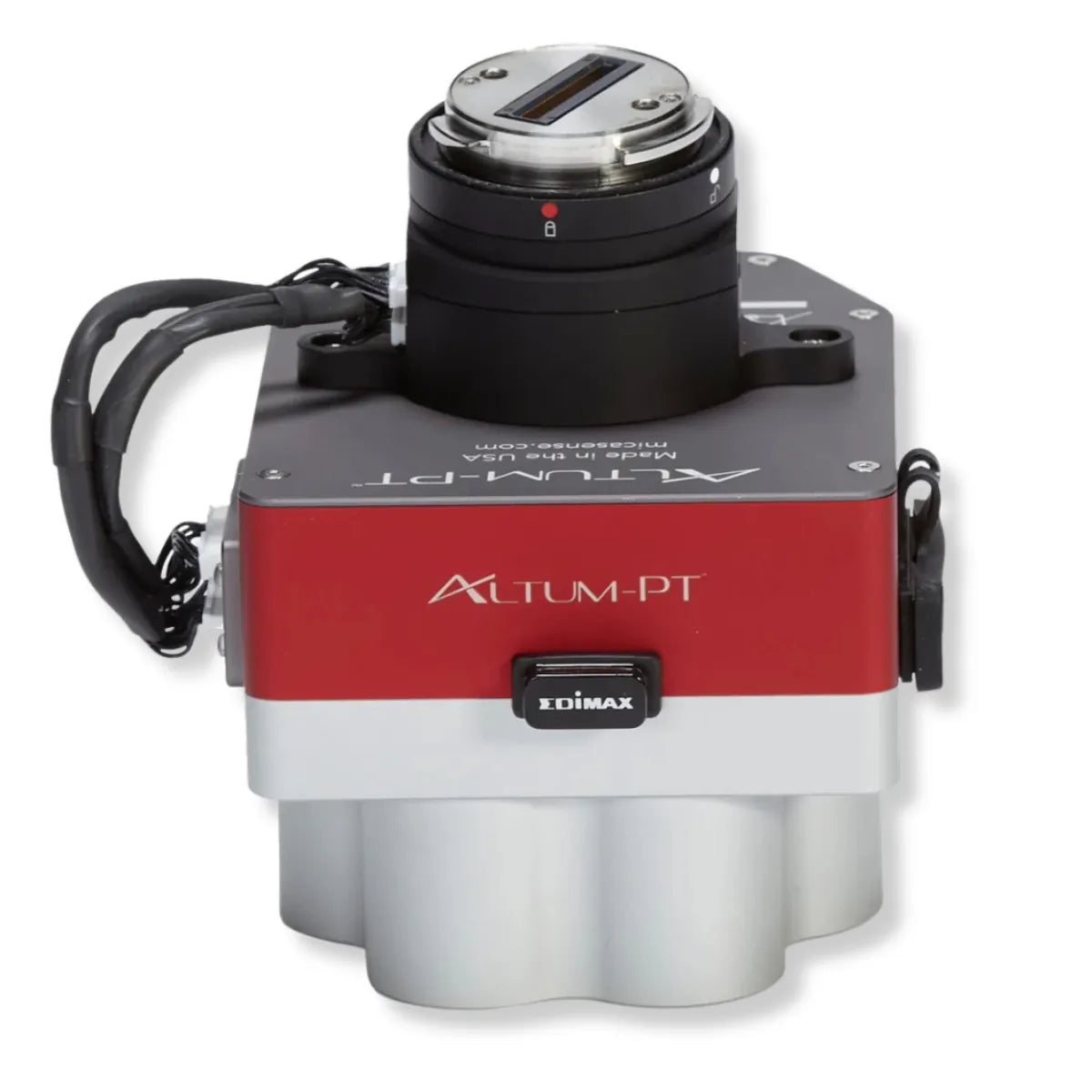
MicaSense Altum-PT with SkyPort Kit: Integrated multispectral, panchromatic, and thermal sensing with direct DJI SkyPort mounting
The MicaSense Altum-PT with SkyPort Kit is a complete enterprise imaging bundle designed for DJI Matrice 300 RTK and Matrice 350 RTK aircraft. It combines the Altum-PT multispectral, panchromatic, and radiometric thermal sensor with the dedicated DJI SkyPort Kit for Altum-PT, enabling direct aircraft mounting and stable alignment.
This bundle simplifies integration while delivering synchronized spectral and thermal datasets in a single flight, supporting professional agriculture, environmental monitoring, and research workflows that demand accurate, repeatable, and spatially precise data.
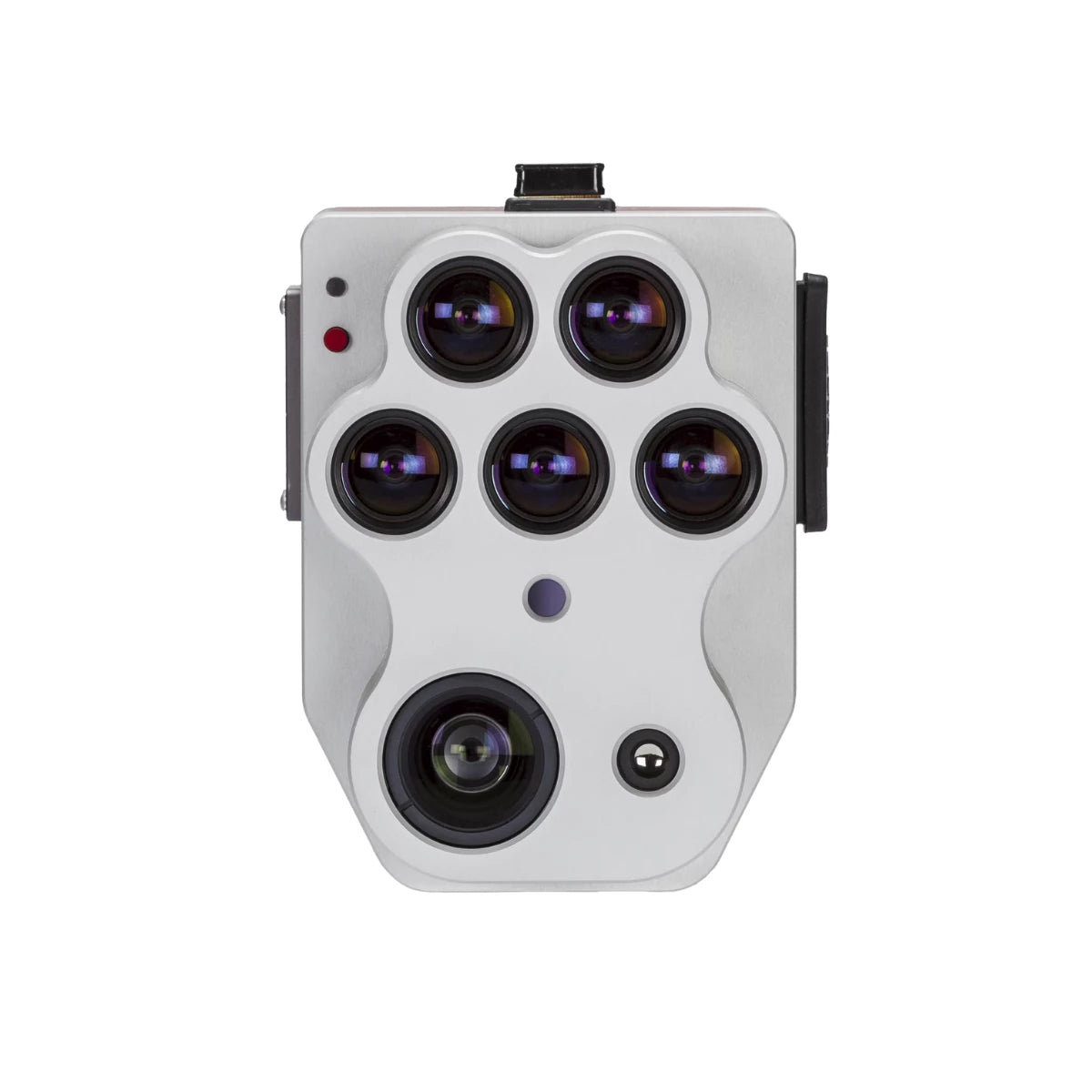
Synchronized multispectral, panchromatic, and thermal sensing system
- Multispectral imaging: 2064 × 1544 resolution, 3.2 MP per band
- Panchromatic imaging: 4112 × 3008 resolution, 12 MP sensor
- Thermal imaging: 320 × 256 radiometric thermal resolution
- Thermal sensor: FLIR LWIR radiometric thermal module
- Thermal spectral range: 7.5–13.5 µm wavelength band
- Synchronized capture: All sensors triggered simultaneously
- Pixel-aligned outputs: Multispectral, panchromatic, and thermal aligned
- Integrated DLS 2: Downwelling light sensor included with Altum-PT
High-resolution outputs for detailed spatial and spectral analysis
Altum-PT is engineered for workflows requiring fine spatial detail and consistent alignment across data types. The 12 MP panchromatic sensor supports pan-sharpened outputs reaching 1.25 cm per pixel at 60 m (200 ft) and 2.49 cm per pixel at 120 m (400 ft).
Multispectral imagery at 3.2 MP per band remains aligned to this spatial detail, enabling precise vegetation analysis. Thermal imagery is captured simultaneously at 320 × 256 resolution, allowing direct correlation between reflectance metrics and surface temperature without temporal offsets.
Thermal insight combined with reflectance-based vegetation metrics
The integrated FLIR LWIR radiometric thermal sensor adds a critical analytical layer to Altum-PT datasets. Operating across the 7.5–13.5 µm spectral range, the thermal sensor supports irrigation analysis, soil moisture assessment, and crop stress detection.
With thermal data captured in sync with multispectral and panchromatic imagery, users can evaluate temperature patterns alongside vegetation indices in a single dataset. This integration improves interpretability and supports more informed decision-making for water management and plant health monitoring.
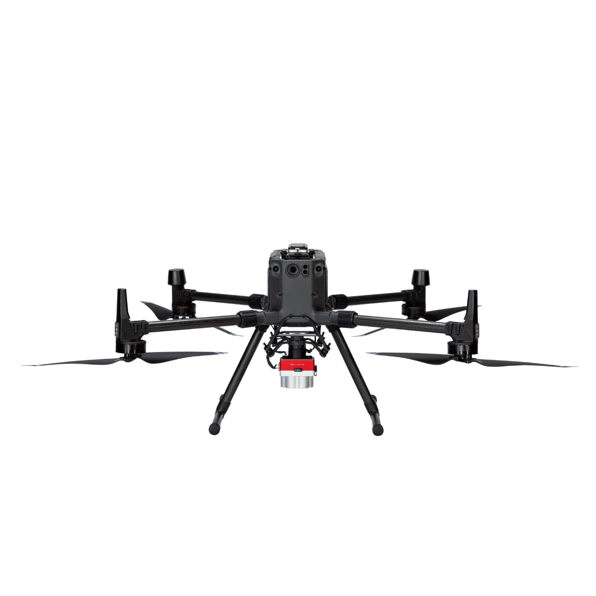
Aircraft compatibility and SkyPort-based integration
- DJI Matrice 300 RTK: Fully supported via included SkyPort Kit
- DJI Matrice 350 RTK: Fully supported via included SkyPort Kit
- DJI Matrice 400: Not supported at this time
- SkyPort adapter included: Direct mechanical and electrical interface
- Secure mounting: Maintains stable sensor alignment during flight
- Simplified installation: Reduces setup time on supported aircraft
Professional applications supported by the bundle
- Irrigation scheduling: Identify water distribution issues using spectral and thermal data
- Plant disease detection: Detect early stress indicators before visual symptoms
- Plant phenotyping: Capture consistent datasets across growth stages
- Yield estimation: Analyze crop vigor and spatial variability
- Water stress prediction: Combine thermal and multispectral indicators
- Environmental monitoring: Support research-grade vegetation analysis
- Precision agriculture mapping: Enable high-resolution, repeatable surveys
- Long-term studies: Maintain consistent radiometric performance over time
Altum-PT vs RedEdge-P (Key Comparison)
| Category | Altum-PT | RedEdge-P |
|---|---|---|
| Primary purpose | Combined multispectral, thermal, and RGB sensing | High-resolution multispectral and RGB imaging |
| Thermal imaging | Yes – radiometric FLIR LWIR (320 × 256) | No thermal sensor |
| Multispectral bands | 5 bands (Blue, Green, Red, Red Edge, NIR) | 5 bands per sensor; up to 10 bands with dual-camera setup |
| RGB / panchromatic sensor | 12 MP panchromatic | 5.1 MP panchromatic (pan-sharpened) |
| Multispectral GSD @120 m | 5.28 cm per pixel | 7.7 cm per pixel |
| Pan-sharpened resolution | 2.49 cm per pixel @120 m (≈1.25 cm @60 m) | ≈3.98 cm per pixel @120 m (≈2 cm with pan-sharpening) |
| Thermal GSD @120 m | 33.5 cm per pixel | N/A |
| Capture rate | Up to 2 images per second (all bands, RAW) | Up to 3 images per second (RAW) |
| Storage | CFexpress card | CFexpress card |
| Radiometric calibration | Integrated multispectral and thermal calibration | Multispectral calibration with dual calibration panels |
| Typical system weight | ≈577 g | ≈745 g (dual-sensor configuration) |
| Best-fit use cases | Irrigation diagnostics, water stress, soil moisture, thermal crop analysis | Vegetation indices, crop vigor, classification, time-series analysis |
Choose Altum-PT if your workflow requires thermal data alongside multispectral imagery, such as irrigation optimization, water stress detection, or soil moisture analysis. Choose RedEdge-P if your priority is higher spectral flexibility, faster capture rates, and advanced vegetation indices for crop monitoring, classification, and long-term time-series analysis.
Designed for enterprise deployment and operational reliability
This bundle is built for professional UAV programs that require dependable integration and consistent data quality. The included SkyPort Kit ensures secure mounting on supported DJI enterprise aircraft, while integrated downwelling light sensing improves radiometric consistency under changing illumination.
Together, the Altum-PT sensor and SkyPort adapter form a deployment-ready system that supports repeatable, high-quality data collection for long-term agricultural and environmental operations.
The MicaSense Altum-PT with SkyPort Kit delivers a complete sensing and mounting solution for teams that require accurate, repeatable, and actionable aerial data.
Available from DSLRPros, backed by enterprise UAS specialists who support integration, deployment, and long-term program success.
