


Inspired Flight IF1200 with GS-ONE + Sony ILX-LR1 Bundle
Inspired Flight IF1200 with GS-ONE + Sony ILX-LR1 Bundle
SKU:B-IF-IF1200-GS1-SONY

- Description
- Specifications
- In the Box
- FAQ
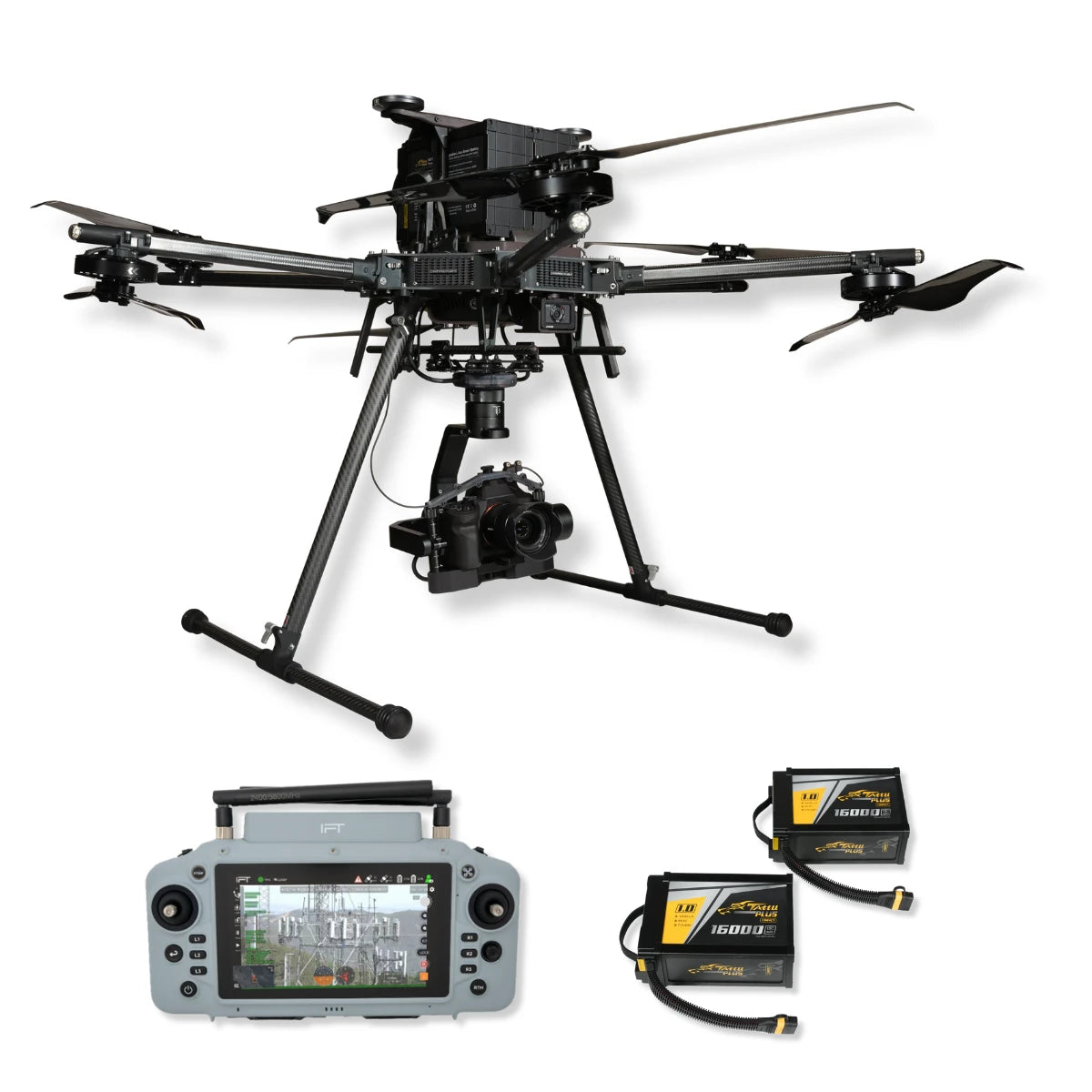
Inspired Flight IF1200 + GS-ONE & Sony ILX-LR1 Bundle: Complete Heavy-Lift Imaging System
This all-in-one bundle pairs the Inspired Flight IF1200A hexacopter with GS-ONE Ground Control Station, a full IF1200 battery set, the required Dovetail Kit 3.0, and the Sony ILX-LR1 payload.
Designed for professional mapping, surveying, and inspection, it delivers endurance, reliability, and high-resolution aerial imaging in a single package.
Built with Blue UAS approval and NDAA compliance, the IF1200A provides mission-ready performance for industries that demand both accuracy and operational security in challenging conditions.
Standout Features
- 43-minute max flight time: supports extended enterprise missions
- 19.1-lb payload capacity: handles cameras, LiDAR, and sensors
- NDAA compliant, Blue UAS approved: cleared for government use
- GS-ONE controller: ruggedized, 7-inch bright touchscreen design
- Hot-swappable battery system: minimizes downtime in the field
- Triple redundant IMUs: enhances safety and flight reliability
- Sony ILX-LR1: 61MP full-frame aerial imaging payload
- Remote camera control: adjust settings during live missions
- Dovetail Kit 3.0: secure and modular payload integration
- Complete battery set: ensures operational readiness
Rugged Flight Platform with Field-Ready Control
The IF1200A offers up to 43 minutes of flight time and supports payloads up to 19.1 pounds. Triple redundant IMUs and robust propulsion deliver dependable operations even in complex environments.
The GS-ONE ground control station features a daylight-readable 7-inch display, IP55 ruggedization, and hot-swappable power, ensuring seamless operation in the field.
Together, they form a stable and intuitive command system for extended flights and precision missions across industries.
Advanced Imaging and Payload Integration
The Sony ILX-LR1 provides 61-megapixel full-frame resolution optimized for aerial mapping and photogrammetry. Its lightweight design mounts securely with the IF1200 Dovetail Kit 3.0, ensuring balance and safety.
Remote control capabilities allow pilots to adjust exposure, shutter, and focus mid-flight, enabling precision capture in real time.
Combined with the IF1200's endurance and payload capacity, this bundle offers a powerful aerial imaging solution engineered for professional workflows where consistency and accuracy matter most.
Applications and Use Cases
- Photogrammetry: produce precise 3D terrain and structure models
- Infrastructure inspection: assess bridges, towers, and transport assets
- Utility monitoring: inspect pipelines, power lines, and substations
- Emergency response: gather rapid situational data in disasters
- Construction surveys: track progress with recurring flight missions
- Forestry and agriculture: evaluate canopy, crops, and habitats
- Urban planning: provide geospatial data for development projects
- Environmental monitoring: document coastlines, erosion, and habitats
- Forensic analysis: capture aerial evidence for investigations
- Industrial asset management: survey large facilities efficiently
This complete bundle delivers flight endurance, payload capacity, and imaging performance in one integrated package. Backed by DSLRPros training and ongoing support, it ensures professionals gain maximum value from every mission.
DSLRPros provides tailored solutions, expert consulting, and dedicated after-purchase care. Purchase your IF1200 + ILX-LR1 bundle today and get expert training and integration support from our experienced team.
