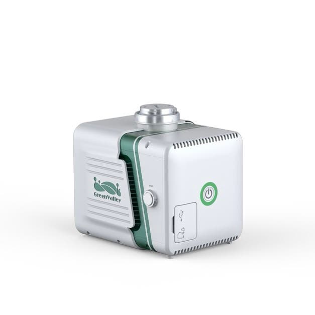
UAV LiDAR Surveying & Mapping Efficiency with the LiAir X3-H
The GreenValley LiAir X3-H is a cutting-edge, high-precision LiDAR payload for UAVs, purpose-built for aerial mapping professionals. As the latest model in GreenValley’s LiAir series, it offers a powerful combination of accuracy, efficiency, and portability for a wide range of applications—such as surveying, forestry, environmental monitoring, and infrastructure inspection.
Lightweight, Integrated Design for Longer Flights
At just 1.25 kg, the LiAir X3-H is a lightweight LiDAR sensor for aerial surveys, ideal for maximizing flight time without compromising performance. Its streamlined design integrates a high-accuracy LiDAR module, advanced inertial navigation system, a 26MP mapping camera, and onboard computing—ensuring reliable data acquisition with minimal setup. Rated IP64, it’s built to withstand dust and light rain, making it a robust choice for fieldwork.
Precision Imaging and Real-Time Data Capabilities
Equipped with a 26-megapixel camera that captures 6252x4168 true-color images, the LiAir X3-H delivers detailed point clouds and orthophotos for high-resolution mapping and photogrammetry. It offers a 190-meter scan range with ±2cm range accuracy—ensuring consistent, reliable results even across large or uneven terrain.
Thanks to real-time data processing with LiAir X3-H, users can view live point clouds, adjust settings, and monitor system status using GreenValley’s LiPlan software. The system integrates directly with DJI Matrice 300 and Matrice 350 RTK remote controllers, giving operators seamless control and enhanced situational awareness during missions.
Versatile and Future-Ready LiDAR Technology
The LiAir X3-H is more than just a UAV payload—it’s a complete solution for modern surveying demands. With optional support for handheld operation, it adapts to a variety of use cases in the field. It also ensures full GreenValley LiAir software compatibility, enabling a smooth workflow from data collection to post-processing.
Wide-Ranging Applications Across Industries
The LiAir X3-H is engineered to meet the needs of professionals across multiple sectors. Its high-precision data output, lightweight build, and real-time functionality make it a versatile tool for both routine surveys and complex field operations.
- Topographic mapping: Generate high-resolution 3D maps for planning, design, and analysis.
- Forestry management: Assess vegetation structure, calculate biomass, and monitor forest health.
- Environmental monitoring: Track terrain changes, land use, and natural resource distribution over time.
- Infrastructure inspection: Safely survey power lines, pipelines, and transportation networks with minimal downtime.
- Mining & quarrying: Perform volume calculations, pit analysis, and progress tracking with precision.
- Disaster response: Quickly map affected areas for emergency planning and damage assessment.
- Agricultural planning: Support precision agriculture with elevation models and canopy structure data.
These diverse use cases, among others, highlight the LiAir X3-H’s ability to deliver actionable insights across a wide range of industries. It provides professionals with the accuracy, speed, and flexibility needed to get the job done right.
Whether you're conducting topographic surveys or monitoring vegetation, the GreenValley LiAir X3-H is a great option for airborne data capture. It's the smart choice for professionals who require speed, accuracy, and adaptability in their LiDAR operations.
Specifications
System Specifications
- Detection Range: 190 m @ 10% reflectivity, 450 m @ 80% reflectivity
- Vertical Accuracy: 5 cm @ 70 m
- Dimensions: 136 × 106 × 129 mm
- Typical Flight Speed: 5–10 m/s
- Weight: 1.25 kg
- Voltage: 12–24 V, 0.9 A @ 24 VDC
- Power Consumption: 22 W
- Storage: 256 GB TF Card
- Operating Temperature: -20°C to 50°C
- Storage Temperature: -30°C to 60°C
LiDAR Sensor Parameters
- Wavelength: 905 nm
- Laser Class: Class 1
- Range Accuracy: 2 cm (1σ @ 20 m)
- Field of View: 70.4° (Horizontal) × 4.5° (Vertical)
- Scan Rate: 720,000 pts/s (Triple Return)
- Number of Returns: 3
- Scan Method: Repetitive Scan
Inertial Navigation System
- GNSS: GPS, GLONASS, Galileo, BDS
- Azimuth Accuracy: 0.038°
- Attitude Accuracy: 0.008°
- IMU Data Frequency: 200 Hz
Camera Parameters
- Image Sensor: APS-C
- Resolution: 26 MP
- Focal Length: 16 mm / 24 mm (Equivalent Focal Length)
- Image Resolution: 6252 × 4168
Software
- Control Software: GreenValley
- Pre-Processing: LiGeoreference
- Post-Processing: LiDAR360 / LiPowerline (Optional)
System Parameters (Handheld Mode)
- Handheld Size: 181.8 × 108 × 88 mm
- Handheld Weight: 0.68 kg (including base)
- Battery Box Size: 146 × 57 × 148 mm
- Battery Capacity: 5870 mAh
- Antenna: AT-106
- Continuous Operation Time (Single Flight): Maximum 55 mins
- Battery Box Weight: 0.81 kg
- Working Time of One Battery Block: 3 hours
Applicable Environment
- Suitable for both indoor and outdoor scenarios
Mapping Method
- Mapping Principle: SLAM, PPK-SLAM
- Real-Time Calculation: Not Supported
Data Results
- Absolute Accuracy: ≤5 cm
- Point Cloud Format: LAS, LiData
In the Box
- 1x GreenValley LiAirX3-H Airborne Laser Scanning Unit


