


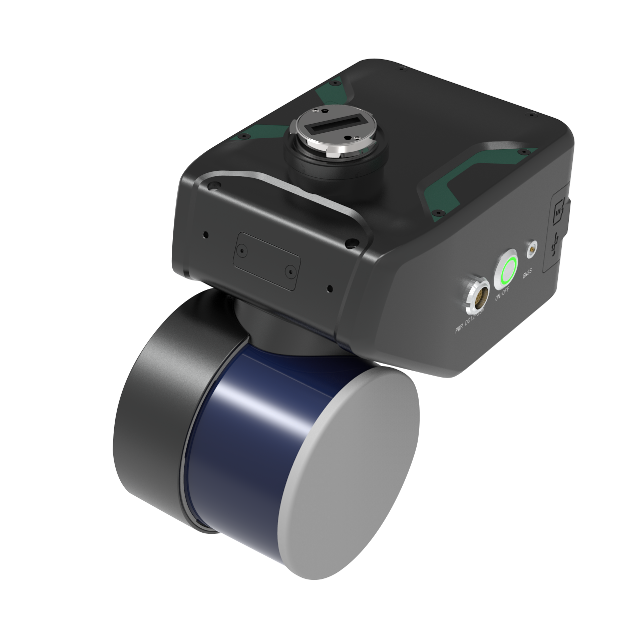
GreenValley LiAir X4: Precision LiDAR for Fully Autonomous Aerial Inspections
Designed for next-generation smart inspection missions, the GreenValley LiAir X4 combines lightweight design with powerful 3D data capture. This airborne LiDAR system integrates a 32-line rotary laser scanner, high-resolution camera, precision inertial navigation, and GreenValley's proprietary AirPilot autonomous flight system. It delivers accurate, real-time, full-coverage point cloud data from both air and handheld operations-even in GNSS-denied environments. With centimeter-level precision and rugged adaptability, the LiAir X4 is built to meet the real-world demands of professionals in utilities, mapping, forestry, and more.
Smarter Autonomous Flights, Safer Powerline Missions
The LiAir X4's AirPilot algorithm enables fully autonomous flight with real-time obstacle avoidance-even across complex powerline intersections and challenging terrain. Its rotary laser design delivers true 360° x 270° omnidirectional scanning with no data blind spots. Field operators can trust the LiAir X4 to identify trees, towers, and terrain changes mid-flight, maintaining safety and accuracy while reducing manual workload. Coupled with RGB tower photos and real-time DEM terrain following, it streamlines power infrastructure inspections like no other.
High-Resolution Data in Complex Environments
From forested slopes to crowded utility corridors, the LiAir X4 adapts to capture complete, georeferenced point clouds even in GPS-denied spaces using its SLAM-based handheld mode. It provides 26MP RGB imagery, true-color point cloud visualization, and centimeter-level accuracy across varied environments. Its robust internal storage and real-time video transmission empower users to make in-flight evaluations with confidence. Whether airborne or handheld, LiAir X4 delivers consistent data quality in every mission scenario.
Key Features and Benefits
- 360° x 270° Laser Coverage: Captures dense, seamless point cloud data in all directions
- AirPilot Autonomous Flight: Avoids obstacles and navigates complex routes without manual input
- GNSS-Antenna-Free Integration: Simplifies DJI M300/M350 RTK installation and deployment
- True-Color Point Cloud Display: Switch between intensity, elevation, and RGB for field QA
- 26MP Mapping Camera: Delivers sharp images and live video during aerial missions
- Lightweight Handheld Kit: Enables SLAM-based scanning in GNSS-denied environments
- Real-Time Terrain Following: Automatically adapts flight height to variable ground surfaces
- Post-Processed Centimeter Accuracy: Supports high-precision georeferenced outputs
Applications and Use Cases
- Powerline Inspection: Crosses lines, identifies poles, and logs tower data autonomously
- Forestry Analysis: Maps vegetation structure and biomass across large forest plots
- Topographic Surveying: Captures elevation data for civil planning and modeling
- Infrastructure Monitoring: Evaluates structural conditions of bridges and buildings
- GNSS-Denied Mapping: Scans tunnels, under dense canopy, or urban environments
As an authorized distributor of GreenValley, DJI Enterprise, and FLIR, DSLRPros offer full solution packages with custom payloads, on-site training, and long-term support. Our experts ensure you get the right tools and know-how to capture actionable geospatial data every time. Contact us to schedule a consult and get your LiAir X4 configured and operational.
Specifications
-
System
- Detection Range
- 80 m @ 10% reflectivity
- 200 m @ 54% reflectivity
- 300 m @ 90% reflectivity
- System Accuracy (Vertical): <5 cm @ 100 m
- Typical Flight Speed: 5-10 m/s
- Storage: 256 GB TF Card + 512 GB Internal SSD
- Weight: 1.44 kg
- Dimensions: 210×120×183 mm
- Voltage: 12-28 V
- Power Consumption: 31 W
- Operating Temperature: -20 to 50 °C
- Storage Temperature: -30 to 60 °C
- Detection Range
-
LiDAR Sensor Parameters
- Wavelength: 905 nm
- Number of Channels: 32
- Laser Class: Class 1
- FOV: 360° (Horizontal) × 40.3° (Vertical)
- Scan Rate: 1,920,000 pts/s (Triple Return)
- Number of Returns: 3
-
Inertial Navigation System
- GNSS: GPS, GLONASS, Galileo, BDS
- Azimuth Accuracy: 0.038°
- Attitude Accuracy: 0.008°
- IMU Data Frequency: 200 Hz
-
Camera Parameters
- Pixels: 26 MP
- Focal Length: 16 mm / 24 mm (Equiv. Focal Length)
- Image Resolution: 6252 × 4168
-
Software
- Control Software: GreenValley
- Pre-Processing: LiGeoreference
- Post-Processing: LiDAR360 / LiPowerline (Optional)
-
Handheld Accessories
-
System Parameters
- Handheld Size: 241.3 × 119.8 × 378.8 mm (Standard)
- Handheld Size: 222.9 × 119.8 × 515.5 mm (Panoramic Camera)
- Battery Box Size: 134 × 64.6 × 167 mm
- Handheld Weight: 1.7 kg (Standard, excluding battery)
- Handheld Weight: 1.9 kg (Panoramic Camera, excluding battery)
- Panoramic Camera Pixel: 12 MP × 2
- Panoramic Camera FPV: H190° × V190°
- Voltage: 15.2 V
- Battery Capacity: 5870 mAh
- Antenna: HX-CH7609A
- Protection Level: IP54
- Working Time of One Battery Block: 2.5 h
-
System Parameters
-
Maximum Continuous Operation Time
- Maximum: 55 min
-
Mapping Method
- Mapping Principle: SLAM, PPK-SLAM
- Real-Time Calculation: Not Supported
-
Data Results
- Absolute Accuracy: <5 cm
- Point Cloud Thickness: <2 cm
- Point Cloud Format: LAS, LiData
In The Box
- 1x GreenValley LiAir X4 Airborne Laser Scanning Unit
