


GreenValley LiAir H600: Lightweight LiDAR System for Precise Aerial Surveying
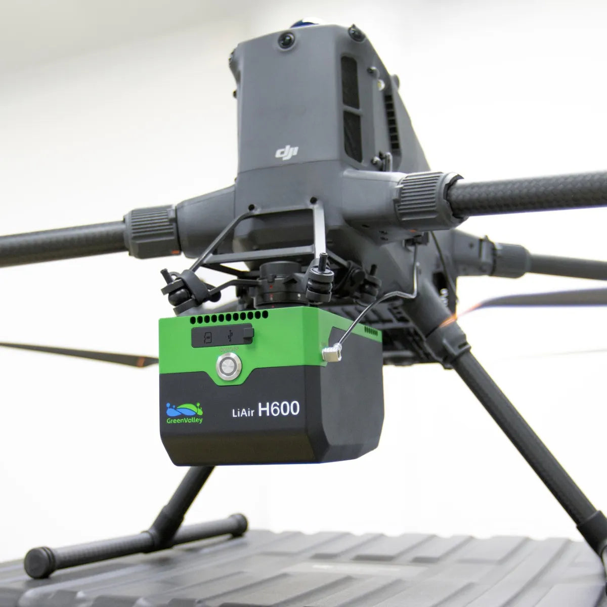
The GreenValley LiAir H600 is a compact, next-generation LiDAR system purpose-built for UAV-based geospatial data collection. Designed for professionals in forestry, utility inspection, and emergency response, this 1.3 kg system integrates high-precision single-line LiDAR, a 26 MP mapping camera, and GreenValley's proprietary inertial navigation. Compatible with small rotorcraft and fixed-wing drones, it delivers centimeter-level accuracy at ranges up to 750 meters, even in vegetated or complex terrain. Seamless compatibility with LiDAR360 and LiPowerline software streamlines post-processing, making the H600 a fully integrated solution from flight to deliverable.
Versatile Performance for Demanding Surveying Missions
The LiAir H600 delivers high-resolution point clouds and sharp aerial imagery from a lightweight platform. With a 550 kHz pulse rate, 80° field of view, and support for up to 7 returns, it captures reliable topographic data-even beneath dense forest canopies. Smart onboard processing adjusts scan parameters in real time, ensuring consistent point distribution and minimizing data redundancy. Whether deployed for routine infrastructure inspections or time-sensitive disaster assessments, the H600 optimizes flight time and data output.
High-Accuracy Mapping Meets Operational Simplicity
This system's advanced integration reduces setup complexity without sacrificing performance. A built-in 26 MP camera streams 720p video live during missions, improving visibility and operator control. The antenna-free GNSS setup-when paired with DJI M300 or M350 RTK-removes installation hurdles while maintaining precise georeferencing. Coupled with intelligent altitude sensing and adaptive flight controls, the LiAir H600 empowers field crews to complete missions faster, safer, and with fewer errors.
Key Features and Benefits
- Medium-range LiDAR coverage: Capture accurate data up to 750 meters away
- Compact 1.3 kg build: Ideal for small UAVs to maximize flight time
- 5 cm elevation accuracy: Ensures dependable 3D terrain modeling
- Penetrates dense vegetation: Up to 7 laser returns reveal ground detail under canopy
- 550 kHz scan rate: Delivers detailed point clouds at high flight speeds
- Integrated 26 MP mapping camera: 4.7 cm GSD resolution at 200 m altitude
- Live 720p/30 FPS video streaming: Maintain real-time awareness during missions
- Adaptive scanning modes: Optimizes point spacing across various terrain
- GNSS antenna-free setup: Simplifies installation on DJI M300/M350 RTK platforms
- Real-time diagnostics and data preview: Minimize rework with in-field verification
Applications and Use Cases
- Powerline inspection: Identify sag, encroachment, and clearance issues from the air
- Forestry surveys: Map canopy structure and terrain below dense vegetation
- Disaster assessment: Rapidly capture post-event terrain for response planning
- Environmental monitoring: Collect terrain and vegetation metrics over large areas
- Corridor mapping: Generate high-density data for roads, pipelines, and utilities
At DSLRPros, we don't just sell drone systems-we design UAV solutions tailored for your mission. As authorized partners of GreenValley International and DJI Enterprise, we ensure seamless hardware integration, expert configuration, and post-sale support. Our seasoned technicians offer training, consultations, and lifecycle services so you can deploy with confidence-whether it's for powerline patrol or precision forestry.
Explore how the LiAir H600 can elevate your survey operations today.
Specifications
-
System Parameters
- System Accuracy (Vertical): ±5 cm @ 200 m
- Weight: 1.3 kg
- Dimensions: 179×114×127.2 mm
- Storage: 256 GB TF Card
- Voltage: 14~24 V, 2.34 A @ 24 VDC
- Power Consumption: About 50 W
- Communication: WiFi / USB-C
- Operating Temperature: -20~50 ℃
- Protection Class: IP64
- Storage Temperature: -20~50 ℃
-
LiDAR Sensor Parameters
- Wavelength: 1535 nm
- Detection Range:
- 267 m @ 10% reflectivity
- 750 m @ 80% reflectivity
- FOV: 80°
- Repeatability Accuracy: 5 mm @ 100 m
- Number of Returns: Unlimited Waveform Returns[1]
- Scan Rate: 100,000~550,000 pts/s
-
Inertial Navigation System
- GNSS: GPS, GLONASS, BDS, Galileo
- Azimuth Accuracy: 0.019°
- IMU Data Frequency: 500 Hz
- Attitude Accuracy: 0.006°
-
Camera Parameters
- Pixels: 26 MP
- Focal Length: 16 mm / 24 mm (Equiv. Focal Length)
- Image Resolution: 6252×4168
-
Software
- Control Software: GreenValley
- Pre-Processing: LiGeoreference
- Post-Processing: LiDAR360 / LiPowerline (Optional)
[1] The theoretical maximum number of returns can only be achieved under specific conditions and is constrained by the actual test scenario.
In The Box
- 1x GreenValley LiAir H600 UAV LiDAR System
