


DSLRPros Inspired Flight IF1200 Agriculture Monitoring Package
DSLRPros Inspired Flight IF1200 Agriculture Monitoring Package
SKU:B-NB-IF1200-AG


- Description
- Specifications
- In the Box
- FAQ
DSLRPros Inspired Flight IF1200 Agriculture Monitoring Package
The DSLRPros Inspired Flight IF1200 Agriculture Monitoring Package is a high-end aerial data collection solution purpose-built for modern precision agriculture.
Combining the heavy-lift, NDAA-compliant Inspired Flight IF1200 hexacopter with the GS-ONE Ground Control Station and the advanced MicaSense Altum-PT multispectral and thermal sensor, this package enables growers, agronomists, and researchers to capture reliable, actionable crop intelligence at scale.
Designed for long endurance, sensor flexibility, and secure enterprise deployment, this system supports everything from crop health analysis and irrigation diagnostics to yield forecasting and research-grade vegetation monitoring.
Package Highlights
- Heavy-lift Inspired Flight IF1200 hexacopter optimized for enterprise missions
- Up to 43 minutes of flight time for large-field agricultural surveys
- NDAA- and Blue UAS–compliant platform for secure operations
- MicaSense Altum-PT multispectral, panchromatic, and thermal sensing in one payload
- GS-ONE Ground Control Station for precise mission planning and autonomous flight
- High wind resistance and SAFE drone system for reliable field operations
- Ideal for crop health, irrigation management, stress detection, and yield analysis
Inspired Flight IF1200A: A Stable, Long-Endurance Platform for Agricultural Mapping
The Inspired Flight IF1200 is a professional-grade hexacopter engineered for demanding data collection missions. In agricultural environments, its long flight time and high payload capacity allow operators to survey large tracts of farmland in fewer sorties, improving efficiency and data consistency.
With up to 43 minutes of flight time using 16,000mAh batteries and strong wind resistance up to 23 knots, the IF1200 maintains stable flight even in open-field conditions. Its SAFE drone system adds redundancy by enabling controlled landings in the event of a motor failure—critical when flying expensive sensors over crops.
Multiple flight modes, dual GPS, and real-time FPV provide the precision and situational awareness required for repeatable agricultural surveys, while the drone’s modular payload interface ensures seamless integration with advanced sensors like the MicaSense Altum-PT.
GS-ONE Ground Control Station: Precision Mission Planning for Farms and Fields
The GS-ONE Ground Control Station is designed to simplify complex agricultural flight operations. It enables operators to plan, execute, and monitor autonomous missions with a high degree of accuracy, ensuring consistent data collection across seasons and growth stages.
Using GS-ONE, users can define survey boundaries, set flight parameters such as altitude and overlap, and automate flight paths optimized for multispectral and thermal imaging. This repeatability is essential for time-series analysis, crop comparison, and monitoring subtle changes in plant health over time.
In large-scale agricultural operations, GS-ONE reduces pilot workload while increasing data quality—making it easier to deploy advanced analytics across multiple fields and crop types.
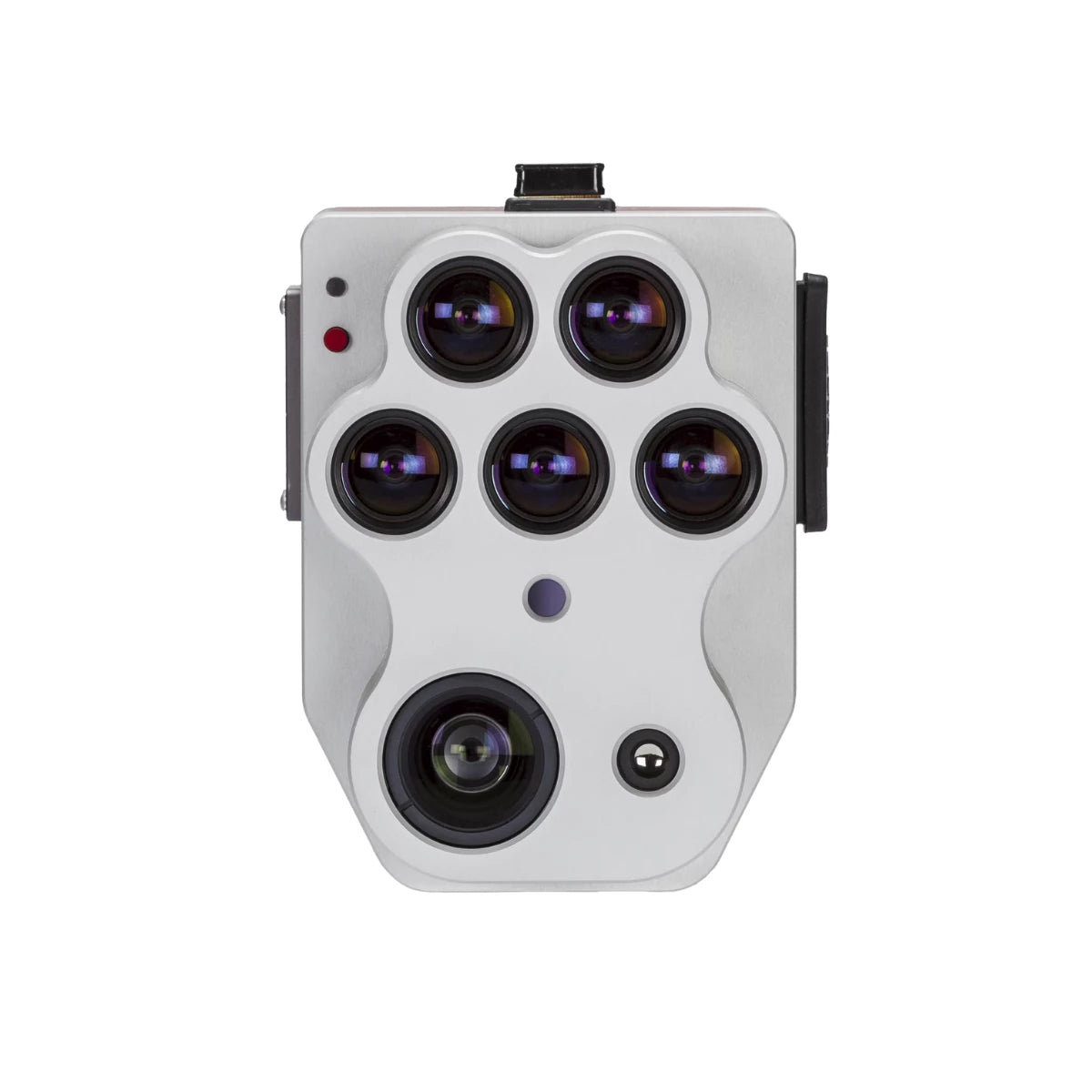
MicaSense Altum-PT: Multispectral and Thermal Intelligence for Precision Agriculture
The MicaSense Altum-PT is a professional aerial sensor that combines five multispectral bands, a high-resolution panchromatic imager, and a radiometrically calibrated thermal sensor into a single, synchronized payload. When paired with the IF1200A, it delivers research-grade data suitable for both commercial agriculture and academic applications.
This integrated design allows multispectral, panchromatic, and thermal imagery to be captured simultaneously in one flight, producing pixel-aligned datasets that improve confidence in analysis and decision-making.
Multispectral and Panchromatic Imaging for Crop Health Analysis
The Altum-PT’s multispectral sensors capture key visible and near-infrared bands used to generate vegetation indices such as NDVI and NDRE. These indices help identify early signs of crop stress, nutrient deficiencies, and uneven growth patterns.
The integrated panchromatic sensor enables pan-sharpened outputs with extremely fine spatial resolution—down to approximately 1.25 cm per pixel at lower altitudes—supporting leaf-level analysis and early intervention.
Thermal Imaging for Irrigation and Water Stress Detection
The radiometrically calibrated thermal sensor adds another layer of insight by measuring plant surface temperature. This data is invaluable for detecting irrigation inefficiencies, soil moisture variability, and water stress before visible symptoms appear.
Because thermal and multispectral data are captured at the same time, agronomists can directly correlate temperature anomalies with reflectance-based crop health indicators, leading to more informed irrigation and resource management decisions.
Agricultural Use Cases Enabled by This Package
- Crop health monitoring and early stress detection
- Irrigation optimization and water distribution analysis
- Soil moisture variability assessment
- Yield estimation and crop vigor mapping
- Plant disease detection before visual symptoms emerge
- Phenotyping and research-grade vegetation studies
- Season-over-season crop performance comparison
A Complete, Enterprise-Ready Agriculture Solution from DSLRPros
By combining the IF1200A platform, GS-ONE Ground Control Station, and MicaSense Altum-PT sensor, this package delivers a powerful end-to-end solution for precision agriculture.
It is designed for operators who need reliable hardware, consistent data quality, and scalable workflows across large agricultural operations.
Available from DSLRPros, this package is backed by experienced UAS specialists who assist with system configuration, sensor integration, training, and long-term support.
From initial deployment to ongoing agricultural programs, DSLRPros helps ensure your drone investment translates into actionable insights and measurable results in the field.
