Skip to product information
1 of 7

Anzu Raptor w/ RTK Module & Charging Hub + 1-Year Care Protection

Anzu Raptor w/ RTK Module & Charging Hub + 1-Year Care Protection

Regular price $5,449.00
Regular price Sale price $5,449.00
Sale Sold out
Shipping calculated at checkout.

SKU:S-NB-RAPTOR

SKU S-NB-RAPTOR MPN RAPTOR01
  • 4/3 CMOS wide-angle camera
  • Foldable and portable
  • 45-minute maximum flight time
  • Fast-charging batteries
  • Split screen zoom capabilities
  • Low light camera mode
  • Advanced obstacle avoidance system
  • Includes an RTK module for accurate positioning
  • Includes a charging hub for efficient 3-way charging
  • Comes with 1-Year Care Protection
View full details
  • Description
  • Specifications
  • In the Box
  • FAQ

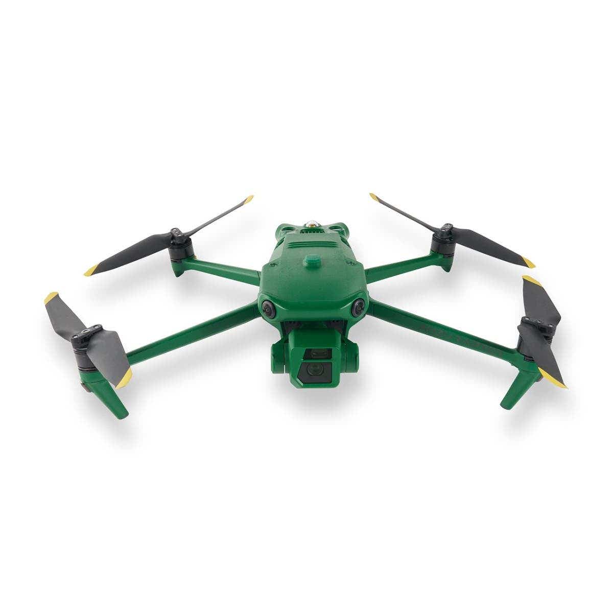
Elevate Your Mission with the Anzu Raptor

The Anzu Raptor is a cutting-edge drone solution crafted to meet the precise demands of industry professionals. Designed and manufactured in the United States, it prioritizes national security, data privacy, and exceptional performance.

Backed by advanced imaging capabilities, unparalleled flight endurance, and seamless operational flexibility, the Anzu Raptor empowers users to excel in specialized fields such as agriculture, search and rescue, and infrastructure inspection.

Precision, Power, and Security

Unrivaled Imaging Technology

  • High-Resolution Visuals: The Anzu Raptor is equipped with a 48MP primary camera, capturing sharp, detailed images to meet the highest professional standards.

  • 56x Hybrid Zoom: Enables precise imaging from significant distances, perfect for inspections and surveillance.

This state-of-the-art imaging system ensures that professionals can collect critical data with accuracy and confidence.

Endurance and Efficiency

  • Extended Flight Time: Operates for up to 45 minutes on a single charge, allowing you to cover extensive areas with fewer interruptions.

  • Long Range: With a range of 9 miles, the drone is ideal for expansive missions, from mapping projects to large-scale inspections.

The Anzu Raptor’s focus on flight endurance reduces downtime and enhances overall productivity.

Enhanced Navigation with RTK

  • Centimeter-Level Accuracy: The Real-Time Kinematic (RTK) module provides exceptional precision for complex applications.

  • Reliable Navigation: Ideal for demanding environments where precision is critical, such as industrial inspections and resource mapping.

Seamless Integration with Professional Tools

  • Third-Party Compatibility: Works with leading platforms like DroneDeploy and DroneLink, enabling automated mapping and tailored workflows.

The Anzu Raptor’s adaptability ensures it integrates effortlessly into existing professional ecosystems, offering a versatile and efficient solution for your needs.

Security and Compliance You Can Trust

  • Data Privacy: All data is stored securely on U.S.-based servers, addressing concerns about foreign-manufactured technology.

  • FAA Compliance: Includes pre-flight checklists and quick LAANC authorizations, ensuring safe, responsible operation within the National Airspace System.

These robust safety and security features give professionals peace of mind and the assurance of compliant, reliable performance.

Revolutionizing Industries

Public Safety and Emergency Response

  • Search and Rescue Missions: Detect and locate missing persons with advanced imaging and thermal capabilities.

  • Firefighting Operations: Identify hotspots and assist with real-time situational analysis.

  • Law Enforcement: Conduct discreet surveillance and gather critical data for investigations.

Agriculture and Environmental Monitoring

  • Monitor crop health, optimize irrigation, and detect pests or diseases with precision imaging.

  • Survey wildlife habitats and track environmental changes without disrupting ecosystems.

Infrastructure and Industrial Inspections

  • Assess powerlines, pipelines, and other infrastructure for maintenance needs or potential hazards.

  • Inspect buildings, bridges, and other structures with high-resolution visuals and accurate data.

Mapping and Surveying

  • Generate detailed maps for urban planning, construction, and resource management.

  • Conduct aerial surveys with RTK-enabled precision for accurate results.

Whether addressing public safety challenges, enhancing agricultural efficiency, or performing critical infrastructure inspections, the Anzu Raptor adapts to meet the specific demands of each industry.

Performance

  • Maximum Horizontal Speed: 47 mph / 75.6 km/h
  • Maximum Ascent Speed: 17.9 mph / 28.8 km/h
  • Maximum Descent Speed: 13.4 mph / 21.6 km/h
  • Maximum Wind Resistance: 26.8 mph / 43.1 km/h
  • Maximum Take-Off Altitude: 3.7 miles / 6 km
  • Maximum Flight Time: 45 minutes
  • Maximum Hover Time: 38 minutes
  • Maximum Tilt Angle: 35°
  • Hovering Accuracy:

    Vision Positioning:

    Vertical: ±0.3' / 0.1 m
    Horizontal: ±1.0' / 0.3 m


    GNSS:

    Vertical: ±1.6' / 0.5 m


    High-Precision Positioning System:

    Horizontal: ±1.6' / 0.5 m


  • Maximum Angular Velocity: 200°/s

Aircraft

  • Rotor Configuration: Quadcopter
  • Propeller Size: 9.4x5.3"
  • Remote ID: Yes
  • Built-In Video Light: No
  • Aircraft I/O: 1x USB-C (Service)
  • Operating Temperature: 14 to 104°F / -10 to 40°C

Imaging

  • Number of Cameras: 3
  • Camera System:

    Thermal: Vanadium Oxide (VOX) Sensor with -4 to 932°F / -20 to 500°C Measurement Range (61° FoV)

  • Digital Zoom:

    Thermal: 28x
    Telephoto: 8 to 56x

  • Minimum Focus Distance:

    Thermal: 16.4' / 5 m
    Wide: 3.3' / 1 m
    Telephoto: 9.8' / 3 m

  • ISO Sensitivity Range:

    Wide: 100 to 25,600
    Telephoto: 100 to 25,600

  • Shutter Speed:

    Wide: 1/8000 to 8 seconds (Photo/Video)
    Telephoto: 1/8000 to 8 seconds (Photo/Video)

  • Maximum Video Resolution:

    Thermal: Up to 512p at 30 fps
    Wide: Up to UHD 4K at 30 fps
    Telephoto: Up to UHD 4K at 30 fps

  • Still Image Support:

    Wide: Up to 48 MP (JPEG)
    Telephoto: Up to 12 MP (JPEG)

  • Photo Modes: Interval, Single Shot
  • Media/Memory Card Slot:

    In Aircraft Body: microSD/microSDHC/microSDXC (UHS-I) [512 GB Maximum / U3/V30 or Faster Recommended]
    In Remote/Transmitter: microSD/microSDHC/microSDXC (UHS-I) [U3/V30 or Faster Recommended]

  • Internal Storage:

    In Remote/Transmitter: 8 GB

Gimbal

  • Number of Axes: 3 (Pitch, Roll, Yaw)
  • Rotation Range:

    Mechanical Range:

    Yaw (Pan): 54° (-27 to 27°)
    Pitch (Tilt): 180° (-135 to 45°)
    Roll: 90° (-45 to 45°)


  • Follow Speed:

    Tilt: 100°/s

  • Stabilization Accuracy: ±0.007°

Avoidance/Sensing System

  • Sensing System: Omnidirectional
  • Sensing System Capabilities:

    Forward:

    Measurement Range: 1.6 to 65.6' / 0.5 to 20 m
    Detection Range: 1.6 to 656.2' / 0.5 to 200 m
    Max Speed: 33.6 mph / 15 m/s
    Field of View: 90° (Horizontal) / 103° (Vertical)


    Backward:

    Measurement Range: 1.6 to 52.5' / 0.5 to 16 m
    Max Speed: 26.8 mph / 12 m/s
    Field of View: 90° (Horizontal) / 103° (Vertical)


    Lateral:

    Measurement Range: 1.6 to 82.0' / 0.5 to 25 m
    Max Speed: 33.6 mph / 15 m/s
    Field of View: 90° (Horizontal) / 85° (Vertical)


    Upward:

    Measurement Range: 0.7 to 32.8' / 0.2 to 10 m
    Max Speed: 13.4 mph / 6 m/s
    Field of View: 100° (Front-to-Back) / 90° (Side-to-Side)


    Downward:

    Measurement Range: 1.0 to 59.1' / 0.3 to 18 m
    Max Speed: 13.4 mph / 6 m/s
    Field of View: 130° (Front-to-Back) / 160° (Side-to-Side)


Remote Controller / Transmitter

  • Control Method: Included Transmitter
  • Operating Frequency:

    2.4 GHz (2.400 to 2.484)
    5.8 GHz (5.725 to 5.850)

  • Maximum Operating Distance: 9.3 miles / 15 km
  • Transmitter Power:

    2.4 G: 33 dBm (FCC), 20 dBm (CE, MIC, SRRC)
    5.8 G: 33 dBm (FCC), 23 dBm (SRRC), 14 dBm (CE)

  • Transmitter I/O:

    1x USB-C (Data, Power)
    1x Mini-HDMI (Video)

  • Clean Video Output: No
  • Battery Type: Built-In Lithium-Ion (5000 mAh)
  • Wi-Fi: Wi-Fi 6 (802.11ax); Tri-Band (2.4, 5, & 6 GHz) with MU-MIMO Support (2 x 2)
  • Bluetooth: 5.1
  • Mobile App Compatible: No
  • Built-In Display: 5.5" (1920 x 1080) Touchscreen LCD, 1000 nits/cd/m²
  • Operating Temperature: 14 to 104°F / -10 to 40°C

Flight Battery

  • Battery Chemistry: Lithium-Ion Polymer (LiPo)
  • Battery Capacity: 5000 mAh / 77 Wh
  • Battery Configuration: 4 S / 15.4 V
  • Maximum Charging Power: 17.6 V
  • Charging Temperature: 41 to 104°F / 5 to 40°C
  • Weight: 11.8 oz / 335.5 g

Charger

  • Charger Input Power: 100 to 240 VAC, 50/60 Hz at 2.5 A
  • Power Rating: 100 W

General

  • GNSS Support: GPS, GLONASS, BeiDou, Galileo
  • Diagonal Size: 15" / 380.1 mm
  • Overall Dimensions:

    Folded: 3.8 x 3.6 x 8.7" / 96.3 x 90.3 x 221.0 mm
    Unfolded: 11.1 x 4.2 x 13.7" / 283.0 x 107.7 x 347.5 mm

  • Weight:

    With Propellers: 2.0 lb / 920 g
    Maximum for Takeoff: 2.3 lb / 1050 g

  • 1x Anzu Raptor aircraft
  • 1x Controller w/ built-in screen
  • 1x Battery
  • 1x Charging Station
  • 1x RTK Module
  • 1x Charging Hub
  • 1 Set Propellers
  • 1x Hard Case
  • Manuals
What payloads are available for Anzu drones?

Payload options include RGB, thermal, EO/IR, and custom third-party sensors—all designed for field interchangeability.

How do Anzu drones compare to DJI for enterprise use?

Anzu drones offer similar modularity and flight performance with the added benefit of secure data handling and U.S.-based operational control, without the restrictions of geofencing found in some DJI models.

What software is compatible with Anzu platforms?

Anzu drones are compatible with leading platforms like Pix4D, DroneDeploy, and AirData for planning, analysis, and fleet management.

Can Anzu drones be used for public safety operations?

Absolutely. Their modular payloads, thermal sensors, and lack of geofencing make them ideal for law enforcement and fire departments.

Do the Anzu Raptor support RTK mapping and surveying?

The Anzu Raptor lineup offers RTK modules for centimeter-level positioning. They are ideal for mapping, construction, and infrastructure work.

Are Anzu drones NDAA-compliant?

No. Anzu drones are not currently NDAA-compliant but are built with secure architecture and designed to support public safety, inspection, and enterprise operations where data control is essential.

How do I register my Anzu Robotics drone with the FAA?

To register your drone with the FAA, follow these steps:

  1. Visit the FAA DroneZone website.
  2. Log in or create an account.
  3. Complete the registration form with your personal and drone details.
  4. Pay the registration fee ($5 for recreational users).
  5. Receive your unique registration number and affix it to your drone.
  6. Keep the registration certificate with you when flying.
  7. Renew your registration every three years.
What does the Anzu Care program cover?

The Anzu Care program includes coverage for:

  • Accidental damage such as collisions and water exposure
  • Repair services or replacement units for damaged drones
  • Expert technical support to resolve questions or concerns

Coverage is provided for the first year after purchase, ensuring reliable support during the initial ownership period.

Can I extend Anzu Care coverage beyond the first year?

No, the Anzu Care program is valid for one year and cannot be extended. After the initial coverage period, repairs and replacements are managed outside the program.

Is Remote ID supported by Anzu drones?

Yes. Anzu drones are Remote ID compliant and ready for both current and upcoming FAA regulations.