


ACSL SOTEN Survey RTK Bundle Plus
ACSL SOTEN Survey RTK Bundle Plus
SKU:S-SOTEN-SURVEY-BUN-PLUS


- Description
- Specifications
- In the Box
- FAQ
ACSL SOTEN Survey RTK Bundle Plus: NDAA-Compliant RTK Mapping System With Five Batteries and IP43 Weather Resistance
The ACSL SOTEN Survey RTK Bundle Plus is a complete, mission-ready aerial mapping and inspection system built around one of the few truly NDAA-compliant enterprise drone platforms available to U.S. operators. Designed and manufactured in Japan by ACSL, the SOTEN combines a lightweight foldable airframe, a 20 MP 1-inch mechanical shutter camera, an integrated RTK module for precision positioning, and a rugged NDAA-compliant TAITEN Smart Controller into a single deployable package.
The Plus variant adds five smart batteries and a triple battery charger, giving field teams the power reserves to run continuous operations across multiple sites without extended downtime between sorties.
Key Features and Benefits
- NDAA compliance: Japan-manufactured airframe with ISO 15408–grade encryption for secure U.S. operations.
- RTK precision: included RTK module enables precise positioning for mapping and survey missions.
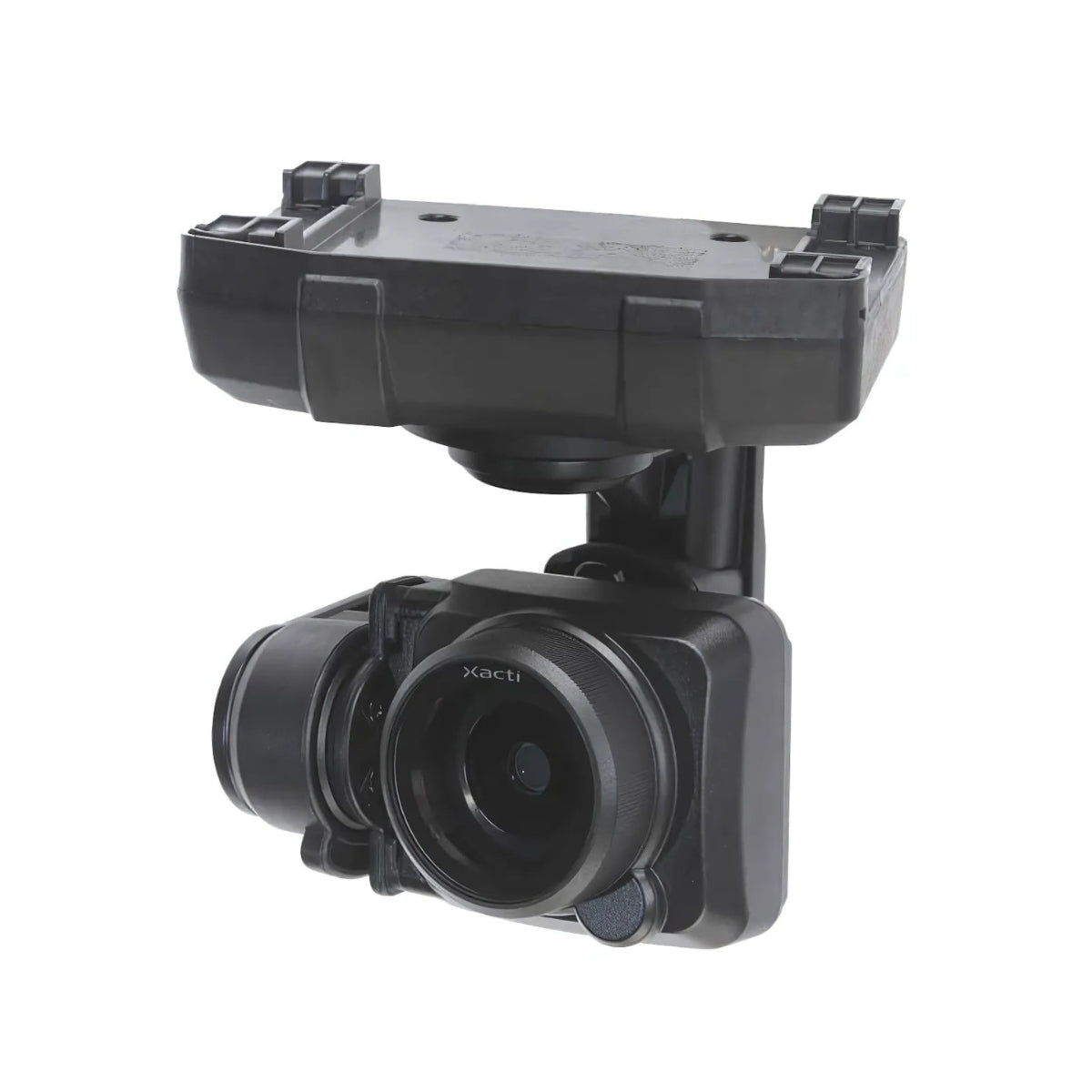
- Mechanical shutter: 20 MP 1-inch sensor eliminates rolling shutter distortion on grid mapping passes.
- Five batteries included: Plus variant ships with five smart batteries for extended multi-sortie field operations.
- IP43 protection: aircraft operates in rain, dust, and debris with camera, gimbal, and battery installed.
- One-touch payload swap: field-swappable camera system supports four distinct payload configurations.
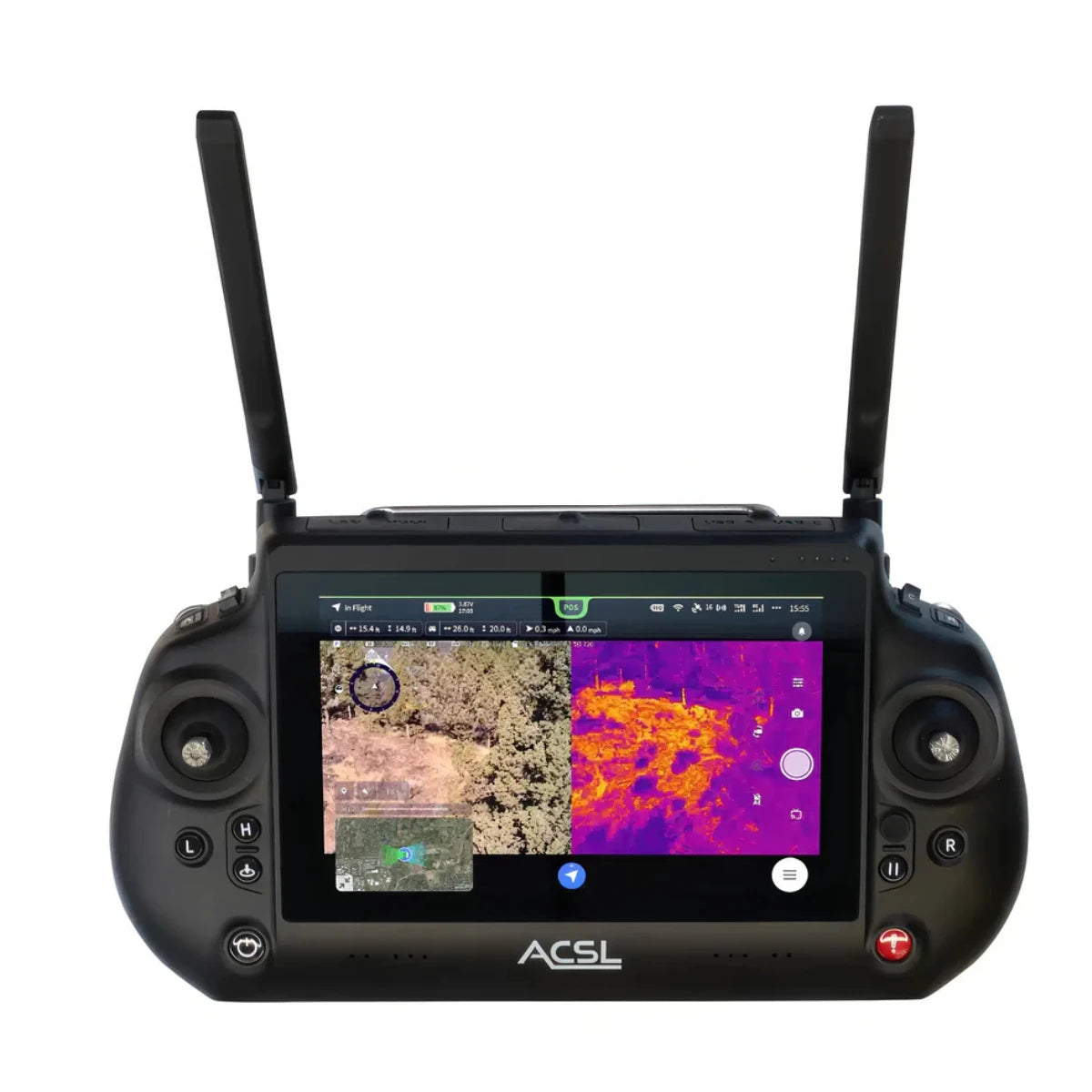
- TAITEN controller: IP54-rated, 1,500-nit, 7-inch daylight display with AES-256 encrypted dual-band link.
- Multi-controller support: up to three TAITEN controllers connect to one aircraft for team-based operations.
- Obstacle sensing: stereo cameras and infrared sensors cover forward, upward, and downward directions.
- Data encryption: onboard recording media encryption protects imagery at rest with enable/disable control.
What sets the SOTEN apart from comparable platforms is its security-first architecture. ISO 15408–grade encryption protects communications, flight data, and imagery at the hardware level, with no forced cloud dependencies and full operator control over data storage and encryption.
Powered by Yamaha-developed motors and rated IP43 with the camera and battery installed, the SOTEN is built to operate in rain, dust, and field conditions that would ground less durable systems.
For U.S. government agencies, defense contractors, critical infrastructure operators, and enterprise teams where data security and regulatory compliance are non-negotiable, the SOTEN Survey RTK Bundle Plus is a purpose-built solution ready for deployment from day one.
Secure Operations From Takeoff to Data Delivery
Security in the SOTEN is not a software toggle—it is built into the hardware architecture from the ground up. The airframe incorporates ISO 15408–grade security measures that govern how communications are encrypted, how flight data is handled, and how imagery is stored, without requiring cloud connectivity or third-party data routing.
The TAITEN Smart Controller adds AES-256 encrypted dual-band communication via ACSL's Fides-Link system, with a 6-mile-plus range in low-interference environments. Onboard microSD recording supports operator-controlled data encryption, allowing teams to lock imagery to the card immediately upon capture.
For operators running missions where data chain of custody matters: government inspection programs, critical infrastructure surveys, law enforcement support; this architecture ensures that what the aircraft sees stays under operator control from takeoff through delivery.
Compatibility and System Integration
- SAMO Thermal/Optical Payload: Teledyne FLIR Hadron 640R thermal sensor plus 64 MP visible camera with 20× zoom. (Sold separately)
- Multispectral Camera: 20 MP 1-inch mechanical shutter sensor capturing 550 nm, 680 nm, and 850 nm wavelengths. (Sold separately)
- Optical Zoom Camera: 25× total zoom (2.5× optical, 10× digital) and 12 MP across an 18–45 mm focal range. (Sold separately)
- LTE Comms Module: optional accessory enabling extended-range and BVLOS-ready communications. (Sold separately)
- ACSL TAKEOFF app: pre-installed on TAITEN for flight operations, camera control, and mission planning.
- Multi-controller pairing: supports up to three TAITEN controllers connected simultaneously to one aircraft.
- Spare batteries: additional 94 Wh lithium-ion smart batteries available separately to extend field endurance.
- NDAA-compliant ecosystem: all core components including airframe, controller, and RTK module meet NDAA requirements.
Applications and Use Cases
- Government and defense inspection: NDAA compliance and ISO 15408 encryption support sensitive U.S. operations.
- Precision mapping and surveying: RTK module and mechanical shutter wide camera support accurate aerial data collection.
- Disaster response: IP43 weather resistance and rapid deployment support time-sensitive emergency missions.
- Infrastructure inspection: one-touch payload swap and optical zoom camera enable detailed close-range documentation.
- Public safety operations: SAMO thermal payload compatibility extends platform capability to nighttime and low-light missions.
- Multi-operator missions: three-controller pairing supports coordinated team-based aerial operations from a single aircraft.
The SOTEN Survey RTK Bundle Plus delivers what most enterprise mapping teams actually need in the field: a compliant, weather-resistant, rapidly deployable platform with enough battery reserves to finish the job in a single site visit.
Its security architecture removes the data handling risk that comes with platforms built around cloud-dependent ecosystems, and its one-touch payload system means a single aircraft can cover mapping, inspection, thermal, and multispectral workflows as mission requirements evolve.
DSLRPros has supplied enterprise UAS solutions to government agencies, public safety teams, and professional survey operations for decades. When you order the ACSL SOTEN Survey RTK Bundle Plus through DSLRPros, you receive expert pre-sale guidance, configuration support, and the after-sale service that complex field deployments require.
Order through DSLRPros today and deploy with confidence from day one.
