


The uses for drones are constantly expanding as new sensors and software are being implemented. We’ve covered uses for public safety including Police, Firefighting, and Search and Rescue. The uses certainly do not stop there. One of the most rapidly expanding drone industries is the use of drones for construction.
MAPPING
Aerial mapping is by far the most important drone functionality for construction companies. From initial planning to progress monitoring, aerial maps are invaluable.
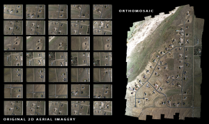
Photo: https://dronemapper.com/
Orthomosaic: An orthomosaic image is multiple aerial photographs stitched together and geometrically corrected so that the scale is uniform. Once the orthomasic imagine is created, users can zoom into each individual picture getting a closer look at the desired area. An orthomosaic image can also be used to measure distances between points within the picture, providing additional information from the mapped area.
Orthomosaic images from drones are particularly helpful because they can be created and updated relatively quickly to give up-to-date maps of real conditions on the ground. This gives construction companies the ability to accurately plan for deliveries, equipment movement, or excavation on a job site, saving valuable time.
3D Maps: Three-dimensional mapping is the process of gathering location information with images from multiple angles so that the locations and the attributes of the items can be displayed and rendered from different angles. Much like the interactive map below.
This map utilized a drone to produce a navigable three-dimensional image for Project Managers to oversee the building of oil storage tanks. The facility also has to have dikes of a certain size to contain the oil if a tank were to be compromised, the construction of which can be monitored and measured in these maps.

LiDAR
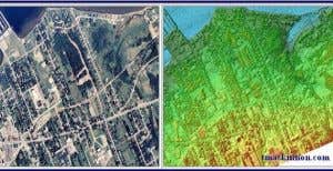
Photo: mackinnon.com
LiDAR, which stands for Light Detection and Ranging, is a remote sensing method that uses light in the form of a pulsed laser to measure ranges (variable distances) to the Earth or another target as each individual application needs. The LiDAR instrument principally consists of a laser, a scanner, and a specialized GPS receiver. So good lighting isn’t necessary since the laser makes its own light!
‘The lidar image (on the right) shows much more accurate elevation data. You can see more precisely where obstructions like trees and buildings stick above the ground, whereas on the orthomosaic ( on the left) the image is very flat. On the other hand, the LiDAR image doesn’t offer details that can be easily discerned by texture (is that a playground or a scrapyard, and which is more important for this project?). – Dronefly.com
PUTTING IT TO USE
Trying to use a drone for construction would be pointless if it didn’t produce accurate, actionable information for the construction companies to use. So how can they utilize this technology to their advantage?
Planning / Surveying
Orthomosaic or 3D maps can give the real-time information necessary to get a build underway, as mentioned earlier. Accurate knowledge of what land needs to be excavated, obstacles removed, or holes filled allows crews to plan ahead for preparation. All before the construction is even underway.
For the builders themselves, the case return on investment is simple. Drones are cheaper to fly than manned aircraft and much faster than human survey teams, and they can collect their data far more often than either. Having this quick, relatively inexpensive technology available can cut days (and therefore dollars) off of a construction company’s bid for a job, giving the company with a drone a big edge.
“The American Institute of Architects believes building-related waste makes up anywhere from 25% to 40% of America’s solid-waste stream. With construction spending in the U.S. totaling $1.13 trillion [in 2016], those losses add up to more than $160 billion in waste—and that’s just in America.
With the right computing tools, builders can turn sensor data into 3D structural models, topographical maps, and volumetric measurements (useful for monitoring stockpiles of costly resources like sand and gravel). Collectively, that intelligence allows construction companies to more efficiently deploy resources around a job site, minimize potential issues, trim costs, and limit delays.” – Fortune
Progress Monitoring & Inspection
Construction is no different from any other lengthy project when it comes to keeping track of progress. The customer wants updates on how far along the project is, whether it is ahead or behind schedule, and a revised estimated time for completion.
The small amount of time and fixed cost of drones makes progress monitoring quick and easy. Send the drone up and you can visibly see how far the construction has progressed. These maps and photographs can be shared with clients to increase project visibility at both ends. This allows building crews to focus on the actual build instead of spending large amounts of time talking to the clients. The information from drones allows Foremen to spot errors (such as misaligned columns) before a building is completed, allowing the issue to be resolved before it becomes a much larger liability.
Monitor Job Sites
Many contractors have simultaneous projects going on at once, a drone allows project managers to monitor multiple sites more frequently. One contractor with a single drone can visit a site, send their drone up, and have a good idea of progress in less than an hour. The time saved can be spent on a site that is behind schedule, in need of assistance, or at a critical juncture in the construction process. Monitoring workers to ensure safety and productivity is crucial to any construction work site. If the Construction Firm has multiple drones, a site foreman can send the drone up and collect the same data without having the head contractor present, saving them even more time.
To sum it up: Drones are faster than human surveyors and they have the ability to collect precise data more frequently, keeping builds on schedule and construction workers safe.
![]()
