Skip to product information
1 of 2

Autel EVO MAX RTK Module

Autel EVO MAX RTK Module

Regular price $529.00
Regular price Sale price $529.00
Sale Sold out
Shipping calculated at checkout.

SKU:S-AR-MAX-RTK

SKU S-AR-MAX-RTK MPN 102002423 UPC 889520209854
  • Designed for Autel EVO Max 4T and EVO Max 4N drones
  • Centimeter-level RTK positioning improves mapping accuracy and geotag precision
  • Supports GPS Galileo and BeiDou GNSS constellations for reliable positioning
  • Enables NTRIP network RTK correction workflows for mapping missions
  • Supports PPK positioning workflows for high-accuracy photogrammetry projects
  • Improves aerial imagery geotagging for professional mapping datasets
  • Reduces reliance on ground control points during survey missions
  • External RTK positioning module designed for EVO Max aircraft
  • Integrates directly with EVO Max GNSS navigation and flight systems

5 total reviews

View full details
  • Description
  • Specifications
  • In the Box
  • FAQ

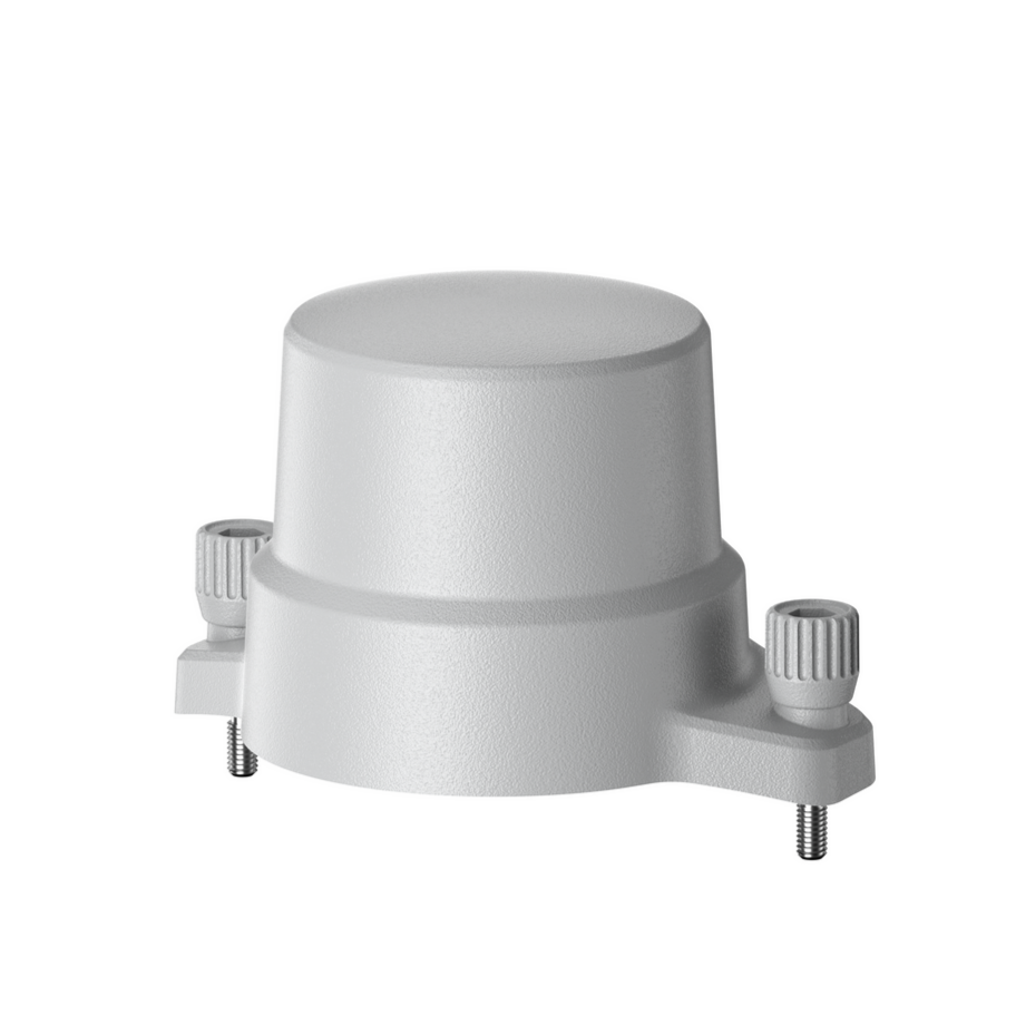
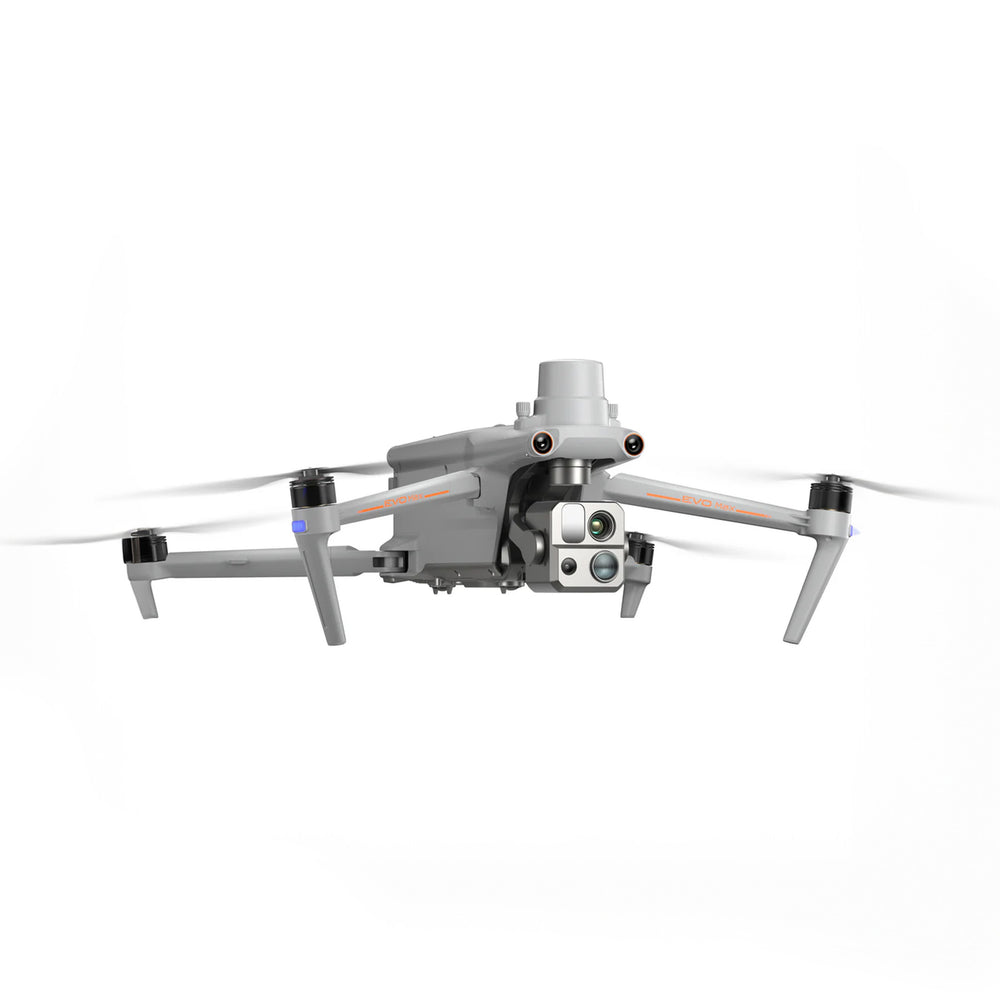
Autel EVO Max RTK Module: Centimeter-level positioning upgrade for EVO Max 4T and 4N

The Autel EVO Max RTK Module is a high-precision positioning accessory designed for the Autel EVO Max 4T and EVO Max 4N drone platforms. By adding Real-Time Kinematic (RTK) satellite positioning, the module delivers centimeter-level location accuracy required for professional aerial mapping, surveying, and precision agriculture workflows.

Supporting multiple GNSS constellations including GPS, Galileo, and BeiDou, the module enhances geospatial accuracy for captured imagery and flight data. This external add-on integrates seamlessly with the EVO Max system to enable reliable, high-precision positioning during demanding enterprise drone missions.

Key features and advantages

  • Real-time kinematic positioning: Enables centimeter-level geospatial accuracy during flight operations
  • Multi-constellation GNSS support: Utilizes GPS, Galileo, and BeiDou satellite networks
  • EVO Max platform integration: Designed specifically for EVO Max 4T and 4N drones
  • Network RTK capability: Supports NTRIP correction services for enhanced positioning accuracy
  • PPK workflow compatibility: Enables post-processed positioning correction for mapping datasets
  • Precision geotagging: Improves location accuracy of aerial imagery for mapping software
  • Reduced ground control requirements: Minimizes reliance on extensive GCP deployment
  • Survey-grade positioning: Supports professional mapping, agriculture, and inspection operations
  • Reliable navigation data: Maintains stable positioning performance near complex structures

Accurate positioning is critical for producing reliable geospatial data from aerial missions. The Autel EVO Max RTK Module enhances the EVO Max platform by delivering the precision required for professional mapping, surveying, and agricultural workflows.

When you purchase from DSLRPros, you gain access to a team with decades of experience supporting professional UAV operations. Order the Autel EVO Max RTK Module from DSLRPros to unlock high-precision positioning for your EVO Max drone platform.

Compatibility

  • Autel Robotics EVO Max 4N
  • Autel Robotics EVO Max 4T

Wireless

  • GNSS support: GPS, Galileo, BeiDou

Global Positioning

  • Supported systems: BeiDou, Galileo, GPS
  • 1x Autel EVO MAX RTK Module
What does the Autel EVO Max RTK Module do?

The Autel EVO Max RTK Module adds Real-Time Kinematic satellite positioning to the EVO Max 4T and EVO Max 4N drones. RTK technology improves the aircraft’s positional accuracy to centimeter-level precision. This allows drone operators to capture highly accurate geospatial data during mapping and surveying missions.

Which drones are compatible with the Autel EVO Max RTK Module?

The Autel EVO Max RTK Module is designed specifically for the Autel EVO Max 4T and Autel EVO Max 4N enterprise drones. It integrates directly with the EVO Max navigation system. It is not intended for use with earlier Autel drone platforms.

Does the Autel EVO Max RTK Module require an RTK base station?

The Autel EVO Max RTK Module can operate with RTK correction sources such as a base station or an NTRIP network service. These correction sources allow the system to calculate centimeter-level positioning accuracy. Without correction data, positioning accuracy will be limited to standard GNSS performance.

Can the Autel EVO Max RTK Module support PPK workflows?

Yes, the Autel EVO Max RTK Module supports positioning workflows that allow Post-Processed Kinematic correction. PPK processing adjusts positioning data after flight using recorded satellite data. This can improve mapping accuracy for photogrammetry and survey projects.

How does the Autel EVO Max RTK Module improve drone mapping accuracy?

The Autel EVO Max RTK Module improves mapping accuracy by providing highly precise geotagging for aerial imagery. Accurate geotags allow mapping software to align images correctly during reconstruction. This produces more accurate orthomosaics, maps, and 3D models.