


Parrot ANAFI USA
Parrot ANAFI USA
SKU:S-PG-ANA-USA


- Description
- Specifications
- In the Box
- FAQ
Parrot ANAFI USA: Tactical-grade thermal and zoom imaging for field operations
The Parrot Anafi USA is a compact, enterprise-ready drone designed for frontline operations. NDAA-compliant and built in the USA, it combines thermal imaging, powerful zoom capabilities, and military-grade security-making it ideal for tactical, industrial, and environmental missions.
Whether you're mapping disaster zones, inspecting infrastructure, or conducting search and rescue, this drone delivers actionable data without compromise.
DJI Parrot Anafi USA Features That Set It Apart
The Parrot Anafi USA packs enterprise power into a compact platform. Engineered for mission-critical operations, it delivers high-performance imaging, secure data handling, and real-time thermal and zoom support-without compromising portability.
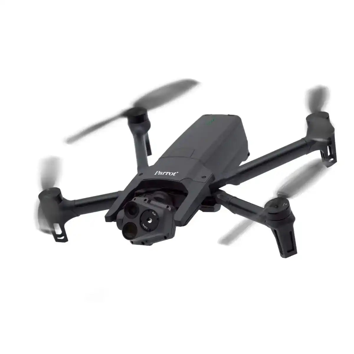
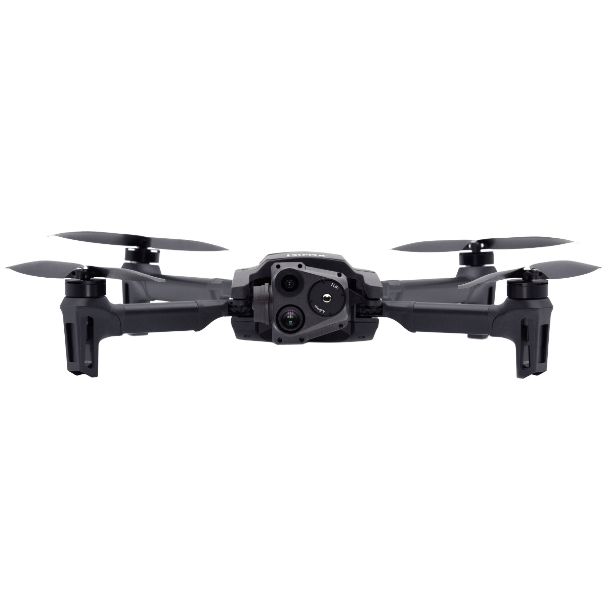
- Triple Sensor Payload: Includes a 32x zoom visual camera, FLIR® Boson thermal sensor, and 4K HDR video, making the Anafi USA ideal for both inspection and surveillance applications.
- Parrot Anafi USA Camera Specs: Visual camera with 1/2.4" CMOS sensor and stabilized 3-axis gimbal enables 4K video and zoom capabilities up to 32x.
- Thermal Imaging: FLIR Boson sensor supports temperature detection and real-time overlays, perfect for low-visibility search, firefighting, and industrial assessments.
- Long Flight Time: Up to 32 minutes per battery enables extended missions with fewer landings and minimal interruptions.
- Secure Data Encryption: Built with AES-XTS encryption and secure boot, meeting high standards for agencies and government users.
Rugged and Ready: Operates in GPS-denied environments and launches in under 60 seconds. Ideal for field ops and emergency response.
Built for Real-World Mapping Workflows
The Parrot Anafi USA is engineered to perform across high-stakes, time-sensitive environments. With its Pix4D compatibility, thermal capabilities, and enterprise-grade camera specs, it supports efficient decision-making whether you're mapping, inspecting, or responding to emergencies. Here's how it delivers in the field:
- Infrastructure Inspections: Monitor bridges, power lines, cell towers, and pipelines-without risking crew safety. The Anafi USA's 32x zoom allows teams to capture sharp visuals from a safe standoff, while thermal imaging can identify hot spots, electrical faults, or insulation failures in real time. Ideal for utility companies, DOTs, and civil engineers.
- Search and Rescue Operations: Whether it's wilderness terrain or post-disaster rubble, this drone helps responders spot heat signatures, detect movement, and coordinate rescue efforts in GPS-denied or low-light conditions. Its lightweight, quick-deploy design means teams can get airborne within seconds-no runway or crew required.
- Site Mapping and Asset Monitoring: Use the Anafi USA to create 2D orthomosaics, document construction progress, and monitor large-scale infrastructure projects. Compatible with Pix4D and other GIS tools, it allows surveyors and project managers to track changes, compare phases, and maintain digital records-all with encrypted image storage for secure reporting.
- Tactical Surveillance: For defense, police, or private security operations, the Anafi USA offers low-noise flight, stealthy thermal monitoring, and live dual-feed video. It supports operations such as perimeter sweeps, covert monitoring, and patrol augmentation-without drawing unwanted attention.
From precision inspections to emergency response, the Parrot Anafi USA's enterprise applications support faster, safer, and more informed operations across sectors that demand reliability in the field.
Advanced Imaging for Critical Situations
The Parrot Anafi USA was built with one mission in mind: give field teams the imaging power they need-when and where it matters most. Equipped with a 32x digital zoom camera and a FLIR Boson thermal sensor, the Anafi USA delivers tactical visibility for both daytime operations and low-light or no-light environments.
Whether you're performing reconnaissance in disaster zones or inspecting power infrastructure from a safe standoff, the Anafi USA's triple-sensor gimbal ensures you never miss a detail:
- 4K HDR Visual Camera: Capture high-resolution stills and video with 3-axis stabilization and up to 32x zoom-ideal for infrastructure, tower, and utility inspections.
- FLIR Thermal Imaging: Detect temperature differentials, locate heat signatures, and overlay thermal data for firefighting, SAR, and security operations.
- Dual-Stream Output: View and record RGB and thermal feeds simultaneously in real time-critical for mission awareness and evidence capture.
- Silent Operation: The Anafi USA's low acoustic signature makes it ideal for discreet tactical work, surveillance, and wildlife monitoringThis payload flexibility and sensor synergy make the Anafi USA camera system a powerful asset across a range of enterprise applications, from emergency response and law enforcement to critical infrastructure monitoring.
Talk to a Drone Expert
Need help comparing payloads or customizing a mapping workflow?Call (213) 262-9436 or click Request Info/Quote to speak with a DSLRPros specialist.
The Parrot Anafi USA provides tactical imaging performance, secure data handling, and rapid deployment capability in a compact and lightweight form. Designed for enterprise and public safety missions, it delivers dependable visual and thermal data when crews need it most. Its balance of portability, endurance, and multi-sensor capability makes it a trusted solution across demanding industries.
At DSLRPros, we provide expert guidance and after-purchase support to ensure your Anafi USA system performs at its best. Purchase the Parrot Anafi USA today and equip your team for mission-ready operations.

