


Drone Trends

Never Miss A Shot: Portable Power Stations for Wildlife Photography and Video...
If you're part of the community that finds themselves trekking through remote jungles, setting up shots in arid deserts, or flying drones as you track wildlife migrations in the heart of the Savannah, you know the challenges that come with the territory. Working solo, collaborating with an NGO on animal behavior studies, conducting anti-poaching surveillance for a government agency, or...
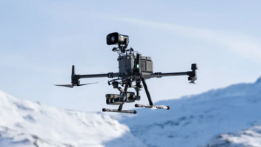
Payloads For Drones In Emergency Response: Guide To What UAVs Carry
Drones are an asset for emergency response teams, due to their rapid deployment and flexibility. They cut down time spent during search and rescue missions, are safer for police teams assessing volatile situations before sending in ground personnel, and even cost a fraction of deploying helicopters whenever there is a callout. The unmanned aerial vehicles (UAVs) versatility expands with the...

The Best 12 Drones for Police in 2024: Full Guide, Reviews And Feature Breakdown
It’s been 2 years since we did a review of the leading police drones, and the industry has changed a lot since then. Tech advancements and newer heavy-duty flagships, tighter FAA regulations, push and pull on Capitol Hill regarding the suitability of foreign-based UAVs – there is so much going on. Police departments on the other hand are strapped for...
Exploring the Raptor Series: An In-depth Review and Analysis Of Anzu Robotics...
After more than a year of negotiations and development, Anzu Robotics finally launched its highly anticipated Raptor and Raptor T drones on April 17, 2024. This American company, based in Austin, Texas, partnered with Syracuse-based Aloft Technologies, resulting in the release of the UAVs with software fully developed within the U.S. This comes in on the backdrop of increased restrictions...

Top 10 Drones For Fire Department UAS Programs
When battling fierce wildfires or blazes tearing through city structures and homes in the suburbs, firefighters confront perilous situations that not only challenge their skills but also put their lives at significant risk. Thick smoke and towering flames can severely limit visibility, making it nearly impossible to assess the full scope of a fire or locate hotspots and trapped individuals....
![Guide For Picking Long Range Drones [Examples & Features Included]](http://www.dslrpros.com/cdn/shop/articles/Header_Guide_For_Picking_Long_Range_Drones_6284a7fd-1470-4291-82fc-303f9cca5b75.webp?v=1743034041&width=533)
Guide For Picking Long Range Drones [Examples & Features Included]
Looking for a drone that can fly further, and remain airborne for longer? This comprehensive guide is for you – and we’ll start right from the basics. What Is A Long-Range Drone? A Look At Capabilities The term "long-range" varies significantly across different drone models and types. It generally refers to drones that can maintain a stable connection and perform...
