


Built for Tactical and Enterprise-Grade Operations
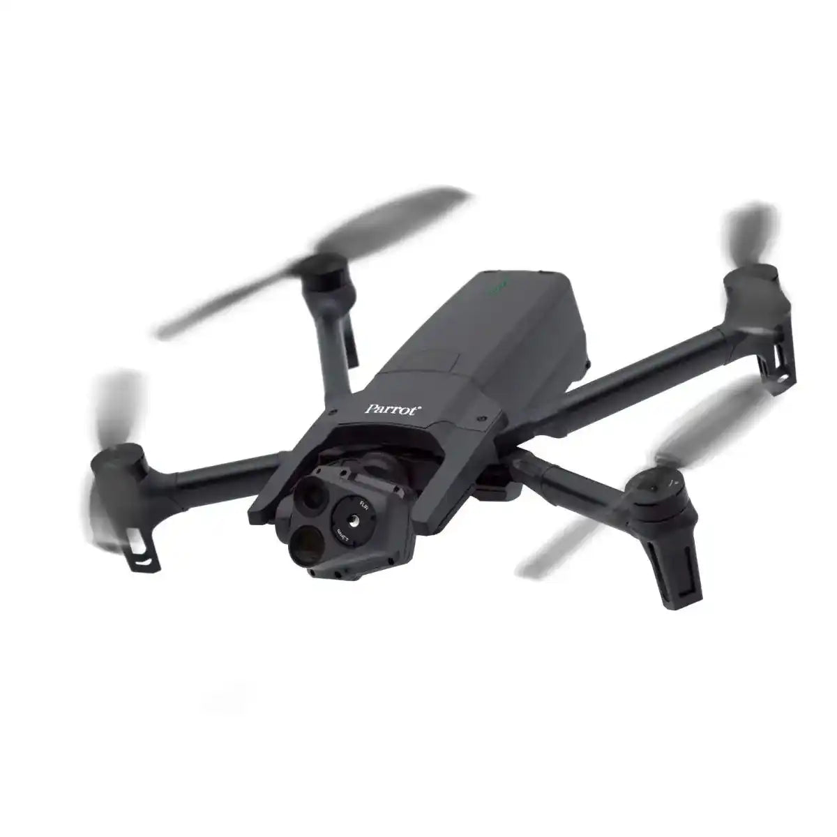
The Parrot Anafi USA is a compact, enterprise-ready drone designed for frontline operations. NDAA-compliant and built in the USA, it combines thermal imaging, powerful zoom capabilities, and military-grade security—making it ideal for tactical, industrial, and environmental missions.
Whether you're mapping disaster zones, inspecting infrastructure, or conducting search and rescue, this drone delivers actionable data without compromise.
DJI Parrot Anafi USA Features That Set It Apart
The Parrot Anafi USA packs enterprise power into a compact platform. Engineered for mission-critical operations, it delivers high-performance imaging, secure data handling, and real-time thermal and zoom support—without compromising portability.
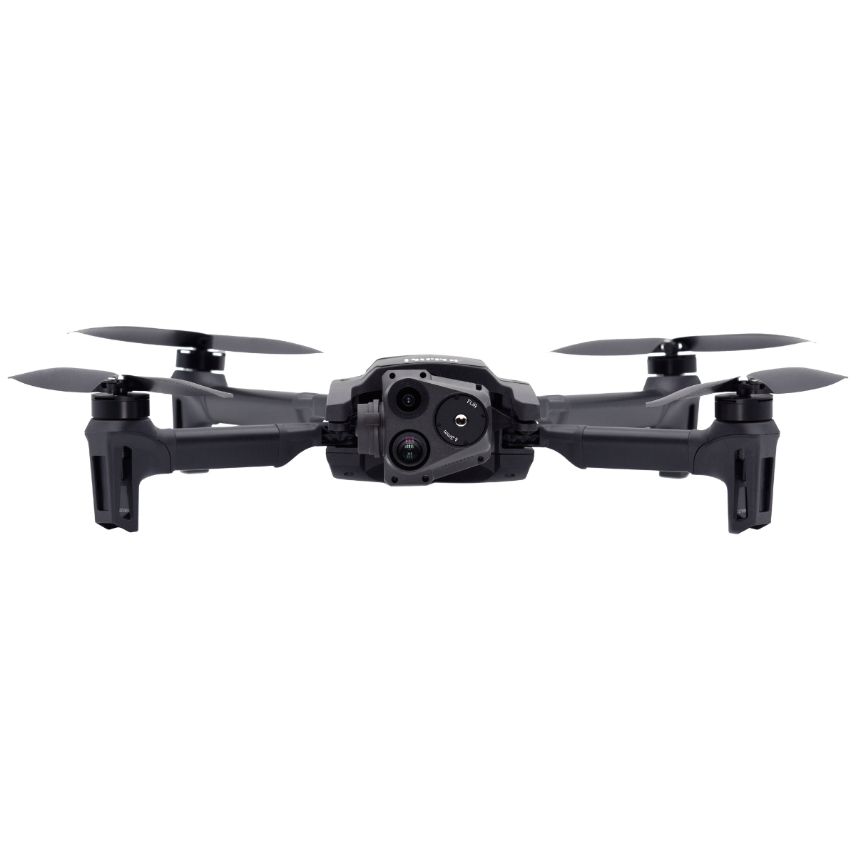
- Triple Sensor Payload: Includes a 32x zoom visual camera, FLIR® Boson thermal sensor, and 4K HDR video, making the Anafi USA ideal for both inspection and surveillance applications.
- Parrot Anafi USA Camera Specs: Visual camera with 1/2.4” CMOS sensor and stabilized 3-axis gimbal enables 4K video and zoom capabilities up to 32x.
- Thermal Imaging: FLIR Boson sensor supports temperature detection and real-time overlays, perfect for low-visibility search, firefighting, and industrial assessments.
- Long Flight Time: Up to 32 minutes per battery enables extended missions with fewer landings and minimal interruptions.
- Secure Data Encryption: Built with AES-XTS encryption and secure boot, meeting high standards for agencies and government users.
Rugged and Ready: Operates in GPS-denied environments and launches in under 60 seconds. Ideal for field ops and emergency response.
Built for Real-World Mapping Workflows
The Parrot Anafi USA is engineered to perform across high-stakes, time-sensitive environments. With its Pix4D compatibility, thermal capabilities, and enterprise-grade camera specs, it supports efficient decision-making whether you're mapping, inspecting, or responding to emergencies. Here’s how it delivers in the field:
-
Infrastructure Inspections
Monitor bridges, power lines, cell towers, and pipelines—without risking crew safety. The Anafi USA’s 32x zoom allows teams to capture sharp visuals from a safe standoff, while thermal imaging can identify hot spots, electrical faults, or insulation failures in real time. Ideal for utility companies, DOTs, and civil engineers.
-
Search and Rescue Operations
Whether it’s wilderness terrain or post-disaster rubble, this drone helps responders spot heat signatures, detect movement, and coordinate rescue efforts in GPS-denied or low-light conditions. Its lightweight, quick-deploy design means teams can get airborne within seconds—no runway or crew required.
-
Site Mapping and Asset Monitoring
Use the Anafi USA to create 2D orthomosaics, document construction progress, and monitor large-scale infrastructure projects. Compatible with Pix4D and other GIS tools, it allows surveyors and project managers to track changes, compare phases, and maintain digital records—all with encrypted image storage for secure reporting.
-
Tactical Surveillance
For defense, police, or private security operations, the Anafi USA offers low-noise flight, stealthy thermal monitoring, and live dual-feed video. It supports operations such as perimeter sweeps, covert monitoring, and patrol augmentation—without drawing unwanted attention.
From precision inspections to emergency response, the Parrot Anafi USA’s enterprise applications support faster, safer, and more informed operations across sectors that demand reliability in the field.
Advanced Imaging for Critical Situations
The Parrot Anafi USA was built with one mission in mind: give field teams the imaging power they need—when and where it matters most. Equipped with a 32x digital zoom camera and a FLIR Boson thermal sensor, the Anafi USA delivers tactical visibility for both daytime operations and low-light or no-light environments.
Whether you're performing reconnaissance in disaster zones or inspecting power infrastructure from a safe standoff, the Anafi USA’s triple-sensor gimbal ensures you never miss a detail:
- 4K HDR Visual Camera: Capture high-resolution stills and video with 3-axis stabilization and up to 32x zoom—ideal for infrastructure, tower, and utility inspections.
- FLIR Thermal Imaging: Detect temperature differentials, locate heat signatures, and overlay thermal data for firefighting, SAR, and security operations.
- Dual-Stream Output: View and record RGB and thermal feeds simultaneously in real time—critical for mission awareness and evidence capture.
- Silent Operation: The Anafi USA’s low acoustic signature makes it ideal for discreet tactical work, surveillance, and wildlife monitoring.
This payload flexibility and sensor synergy make the Anafi USA camera system a powerful asset across a range of enterprise applications, from emergency response and law enforcement to critical infrastructure monitoring.
Talk to a Drone Expert
Need help comparing payloads or customizing a mapping workflow?
Call (213) 262-9436 or click Request Info/Quote to speak with a DSLRPros specialist.
Specifications
Drone
- Size (folded): 252 × 104 × 84 mm
- Size (unfolded): 282 × 373 × 82 mm
- Size (unfolded on MIL version): 282 × 373 × 192 mm
- Mass: 500 g / 1.10 lb
- Maximum Take-off Mass (MTOM): 644 g / 1.42 lb
- Maximum Flight Time: 32 minutes (30 minutes on MIL version)
- Maximum Horizontal Speed: 14.7 m/s
- Maximum Ascent Speed: 4 m/s (6 m/s on unlocked SE, GOV, and MIL versions)
- Maximum Descent Speed: 3 m/s
- Maximum Wind Resistance: 14.7 m/s
- Maximum Propeller Speed: 11,000 rpm
- Sound Power Level at 1 m (3 ft): 84 dB
- Service Ceiling: 5,000 m above MSL (Mean Sea Level)
- User Defined Geofencing: Supported
- IP Rating: IP53 (dust and rain resistant)
- Operating Temperature: -33 °F (-36 °C) to +122 °F (+50 °C)
- No Take-off Temperature Limitations: Supported
Security
- Zero Data Shared by Default: Supported
- SD Card Encryption: AES-XTS encryption with a 512 bits key
- Network Connections: WPA2 AES CCMP encrypted
- Firmware: Digitally signed
Sensors
- Satellite Navigation: GPS, GLONASS, & GALILEO
- Barometer and Magnetometer: Supported
- Vertical Camera and Ultra-sonar: Supported
- IMU: 2 × 6-axis
- Accelerometers: 2 × 3-axis
- Gyroscopes: 2 × 3-axis
EO Image Chain
- Sensors: 2 sensors (1/2.4")
- Digital Zoom: 32x
- Electronic Shutter Speed: 1 s to 1/10,000 s
- ISO Range: 100 - 3200
- Video Resolution: 4K/FHD/HD
- Video Format: MP4 (H.264)
- Photo Resolutions:
- Wide: 21 MP (84° FOV)
- Rectilinear: up to 16 MP (up to 75.5° FOV)
- Photo Formats: JPEG, DNG (Digital NeGative RAW)
IR Image Chain
- Sensor: FLIR BOSON
- Digital Zoom: 32x
- Temperature Range: -40°C to +150°C
- Thermal Sensitivity: ≤60 mK
- Measured IR Wavelength Range: 7.5 to 13 micrometers
- Video Resolution: 1280 × 720 px
- Video Format: MP4 (H.264)
- Framerate: 9 fps
- Photo Resolution: 320 × 256 px
- Photo Format: JPEG
Image Stabilization
- Stabilized Gimbal: 3-camera IR/EO
- Hybrid Stabilization: 3-axis
- Mechanical Stabilization: 2-axis roll/pitch
- Electronic (EIS): 3-axis pitch/roll/yaw
- Controllable Gimbal Tilt Range: -90° to +90°
Fast-Charging Smart Battery
- Type: High density LiPo (3 × 4.4 V cells)
- Capacity: 3,400 mAh
- Battery Life: 32 minutes
- Charging Port: USB-C
- Charging Time: Charges in 2 h with a USB-PD (Power Delivery) charger
- Mass: 195 g / 0.43 lb
- Voltage: 11.55 V
- Maximum Charging Power: 30 W
Parrot Skycontroller 4
- Size (without device): 238 × 147 × 55 mm
- Maximum Size: 315 × 147 × 55 mm
- Mass: 610 g / 1.34 lb
- Transmission System: Wi-Fi 802.11 a/b/g/n
- Operating Frequencies: 2.4 GHz, UNII-1 & UNII-3
- Direct Video Stream Resolution: 720p
- Battery Capacity: 3,350 mAh 7.2 V
- Charging Time: 3 h 45 min
- Battery Life: Between 3 h and 6 h (varies according to the device used and its state of charge)
- Compatibility: Compatible with all smartphones and tablets up to 8"
- Ports: 2 × USB-C (charging and connecting), micro-HDMI
- IP Rating: IP5X (dust resistant)
Parrot Skycontroller USA
- Size: 313 × 208 × 72 mm
- Size (with antenna unfolded on MIL version): 313 × 208 × 173 mm
- Mass: GOV version: 1.14 kg / 2.51 lbs, MIL version: 1.16 kg / 2.56 lbs
- NDAA & TAA Compliant: Supported
- Transmission System: Wi-Fi 802.11 a/b/g/n (+ additional Microhard radio on MIL version)
- Operating Frequencies: 2.4 GHz, UNII-1 & UNII-3
- Direct Video Stream Resolution: 720p
- Battery Capacity: 5,000 mAh 7.2 V
- Charging Time: 2 h
- Battery Life: 4 h 30 min
- Based On: 8" Samsung Galaxy Tab A
- Ports: USB-C, USB-A, Ethernet
- IP Rating: IP53 (dust and rain resistant)
ANAFI USA MIL
- Radio: Microhard pDDL1800 1.8 GHz
- TOGA (Tactical Open Government Architecture) Compatible: Supported
- Foldable Antennas: Supported
- AES 256 Encryption: Supported
- Additional Mass: 20 g on ANAFI USA; 20 g on the Skycontroller USA
Ecosystem
- Open Source SDK for Developers: Supported
- Extensive Partner Program: Supported
In the Box
- 1x ANAFI USA drone
- 3x smart batteries (3x32 minutes)
- 1x Skycontroller 4
- 1x tablet holder
- 1x multi-port fast USB charger
- 1x additional set of propeller blades
- 4x USB-A/USB-C cables
- 1x hard case

