


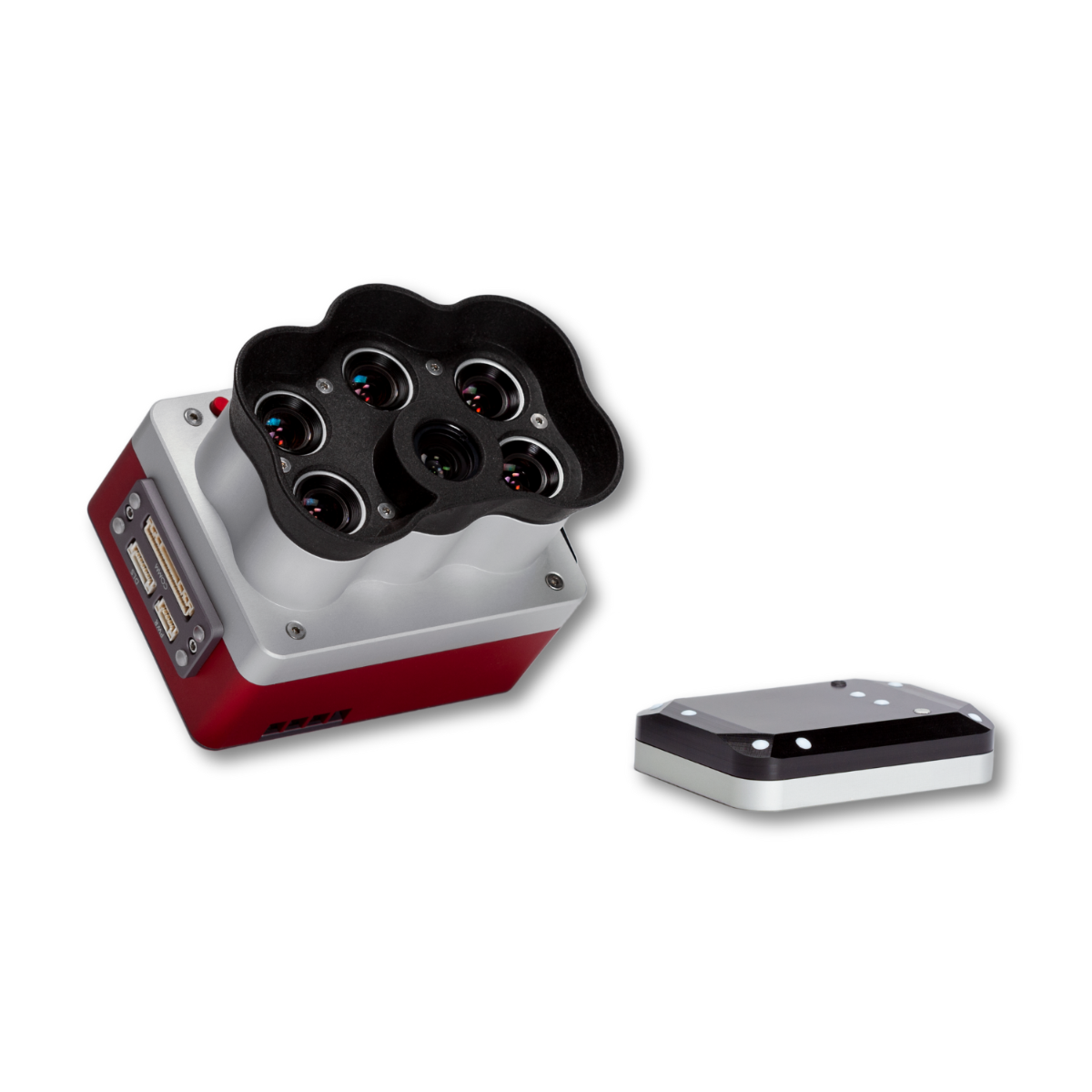


MicaSense RedEdge-P Camera for High-Precision Crop and Environmental Monitoring
The MicaSense RedEdge-P camera is a professional multispectral and RGB imaging solution built for precision agriculture, environmental monitoring, and vegetation analysis. Designed for integration with enterprise UAVs such as the DJI Matrice 350 RTK, it delivers leaf-level detail and accurate data for crop health mapping, ecosystem surveys, and resource management.
Its five discrete spectral bands, pan-sharpened imagery, and rugged build make it an essential payload for professionals who require consistent, reliable results in the field.
Key Benefits for Professional Operators
The RedEdge-P gives you more than raw imagery—it delivers actionable insights. By capturing synchronized multispectral and RGB data, you can reduce flight time, cut operational costs, and improve decision-making accuracy.
- Precision crop health mapping – Generate NDVI and other vegetation indices to detect stress early.
- Leaf-level resolution at low altitudes – Pan-sharpened imagery reveals detail essential for targeted interventions.
- Field-ready durability – Weather-resistant construction keeps missions on schedule, even in challenging environments.
- Seamless UAV integration – Fully compatible with the DJI Matrice 300 RTK and supported by industry-standard processing platforms.
Technical Specifications at a Glance
| Specification | Detail |
|---|---|
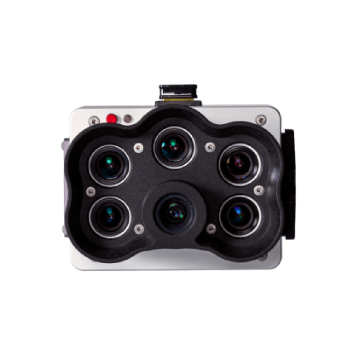
| Spectral Bands | Blue, Green, Red, Red-Edge, Near-Infrared (NIR) |
| RGB Resolution | 6.4 MP (pan-sharpened) |
| Multispectral Resolution | 1.6 MP per band |
| Lens Type | Global shutter |
| Capture Mode | Simultaneous multispectral and RGB |
| Weight | 240 g |
| Operating Temperature | 0°C to 40°C |
| Compatibility | DJI Matrice 300 RTK, other supported UAVs |
| Processing Software | Pix4D, Agisoft Metashape, MicaSense Atlas |
Industry Applications for the RedEdge-P Camera
This sensor supports a range of professional workflows where precise vegetation and terrain data are mission-critical.
Precision Agriculture
Monitor plant health across entire fields, detect nutrient deficiencies early, and fine-tune irrigation schedules. By analyzing multispectral data, you can improve yield forecasts and optimize inputs.
Environmental Monitoring
Track ecosystem changes, study plant species distribution, and assess vegetation health for conservation planning. Its high-accuracy data supports reliable environmental reporting.
Forestry Management
Identify pest damage, monitor forest regeneration, and plan logging or preservation efforts with detailed canopy analysis.
Water Resource and Irrigation Planning
Pinpoint irrigation inefficiencies and identify areas under water stress to conserve resources without reducing yields.
Land Use and Soil Analysis
Map soil variability, identify erosion risks, and improve land management strategies for both agriculture and restoration projects.
Why Professionals Choose DSLRPros for the MicaSense RedEdge-P
- Authorized MicaSense reseller – Guaranteed authentic equipment with full manufacturer warranty.
- Expert technical guidance – From UAV integration to workflow optimization, our team supports your mission from setup to execution.
- Fast, secure shipping – We prioritize quick delivery so you can deploy without delays.
Frequently Asked Questions
-
What is the MicaSense RedEdge-P used for?
It’s designed for multispectral and RGB imaging in agriculture, environmental research, and forestry management to generate accurate vegetation indices and high-resolution maps. -
What drones are compatible with the RedEdge-P?
It’s fully compatible with the DJI Matrice 300 RTK, M350 RTK and other UAV platforms with appropriate mounting and integration. -
What is the resolution of the RedEdge-P?
It captures 1.6 MP per multispectral band and delivers 6.4 MP pan-sharpened RGB images. -
Does the RedEdge-P capture RGB and multispectral at the same time?
Yes. It captures both in a single flight pass, reducing operational time and improving efficiency. -
Is the RedEdge-P suitable for environmental monitoring?
Yes. Its multispectral data supports habitat analysis, vegetation health monitoring, and land use change studies.
Equip Your Drone with the MicaSense RedEdge-P Camera
Enhance your UAV operations with precision crop health mapping, pan-sharpened imagery, and proven compatibility with enterprise drones.
Order the MicaSense RedEdge-P camera from DSLRPros today and get:
- Expert setup assistance
- Fast delivery
- Full manufacturer warranty
Looking for more DJI Matrice 300 RTK payloads?
Browse our full collection of compatible sensors and accessories.
Specifications
- Weight: 300g (10.6 oz.) RedEdge-P + DLS 2
- Dimensions: 8.2 x 6.2 x 5.4 cm (3.2in x 2.4in x 2.1in)
- External power: 7.0 V-25.2 V
- Spectral bands: Blue, green, red, red edge, near-IR(global shutter, narrowband)
- Wavelength (nm): Blue (475 nm center, 32 nm bandwidth), green (560 nm center, 27nm bandwidth), red (668 nm center, 14 nm bandwidth), red edge (717 nm center, 12nm bandwidth), near-IR (842 nm center, 57 nm bandwidth)
- RGB output: 5.1 MP (global shutter, aligned with all bands)*
-
Ground sample distance:
- o7.7cm per pixel (per MS band) at 120m AGL
- o3.98cm per pixel (panchromatic band) at 120m AGL
- Capture rate: 2-3 captures per second raw DNG
- Interfaces: 4 GPIO: Trigger input, top of frame out, 1 PPS out, host button. USB 2.0 port for WiFi, serial, 10/100/1000 ethernet, and CF Express Storage.
- Field of view:o49.6° HFOV x 38.3° VFOV (MS)o44.5° HFOV x 37.7° VFOV (PAN)
- Triggering options: Timer mode, overlap mode, external trigger mode (PWM, GPIO,serial and Ethernet options), manual capture mode
- Heat: 0-40C ambient (no airflow); 0-50C ambient with airflow >0.5m/s
* with appropriate post-processing
Note: Specifications are subject to change without notice

