


Built for Search, Rescue, and Real-Time Decision Making
The Anzu Raptor T drone combines dual thermal and visual cameras, rugged construction, and advanced flight autonomy in a compact, NDAA-compliant airframe. Whether you're flying tactical missions, search and rescue operations, or critical inspections, the Raptor T is designed for professionals who need clarity, control, and fast deployment.
Powered by U.S.-based software and firmware, the Raptor T offers geofence-free operation, secure data workflows, and native integration with Anzu’s thermal camera payload. With hot-swappable batteries, obstacle sensing, and a 45-minute max flight time, this drone is ready for real-world missions — not just specs on a page.
Key Features of the Anzu Raptor T Thermal Drone
The Raptor T drone for public safety and inspection teams comes packed with hardware and software built for speed, visibility, and operational confidence.
- High-Res Thermal Camera (640×512): Pinpoint hotspots, people, or equipment failures with radiometric precision.
- 4K Visual Camera with 20x Zoom: Capture daytime visuals or low-light footage with detail and stability.
- 1-Year Care Protection Included: Covers accidental damage and priority support — fly with peace of mind.
- Obstacle Avoidance: 360° sensing improves safety during close-quarters navigation.
- Geofence-Free Deployment: Launch when and where you need — no firmware restrictions.
- Dual Operator Mode: Let a second pilot control the camera while the first handles flight — ideal for live missions.
- Autonomous Flight Modes: Plan missions with waypoints or use follow-me and orbit functions on the fly.
-
Made for Government & Enterprise: NDAA-compliant, no forced cloud sync, and backed by U.S.-based support.
Real-World Use Cases for the Anzu Raptor T Drone in Public Safety and Rescue
From disaster zones to infrastructure corridors, the Raptor T drone for search and rescue missions helps professionals assess, act, and adapt in real time.
-
Search and Rescue
Detect missing persons using thermal imaging, even in total darkness or dense terrain.
-
Firefighting & Overhaul
Spot flare-ups, hotspots, or structural heat signatures during or after active fire scenes.
-
Law Enforcement
Gain aerial overwatch, monitor crowd movement, or locate suspects without endangering teams.
-
Infrastructure Inspection
Identify thermal anomalies in solar panels, substations, and high-voltage lines.
-
Disaster Response
Assess damage and locate survivors quickly after storms, earthquakes, or floods.
-
Event Security
Monitor perimeters and track movement from a secure vantage point.
Best Use Cases for the Anzu Raptor T Drone in Public Safety, Rescue, and Inspection
The Anzu Raptor T excels in missions that demand fast deployment, thermal imaging, and visual clarity — whether you're searching for survivors, monitoring a fireground, or inspecting utility infrastructure. Here’s where it delivers the most value:
| Mission Type | Why the Raptor T Excels |
|---|---|
| Search and Rescue (SAR) | Thermal imaging locates heat signatures in low-visibility terrain. Long flight time supports wide-area sweeps. |
| Firefighting and Overhaul | Detect residual hotspots and monitor fire spread through smoke using thermal overlays. |
| Law Enforcement & Tactical Response | Dual-operator mode and zoom optics enable discreet tracking and overwatch during live incidents. |
| Utility & Infrastructure Inspection | Radiometric thermal data highlights overheating components or equipment faults without endangering personnel. |
| Disaster Response & Damage Assessment | Quickly survey hard-to-reach areas for structural damage or survivors using high-res visual and thermal feeds. |
Is the Anzu Raptor T Drone Right for My Operation?
If your team needs a secure, field-ready thermal drone with dual-camera versatility and no geofencing, the Raptor T fits the mission. It's a strong alternative to DJI enterprise models — without the export restrictions, cloud dependencies, or firmware lockouts.
Build My Bundle
Pair your Anzu Raptor T with the right batteries, software, and deployment case. DSLRPros will help you configure a public safety or inspection-ready package from day one.
Call 877-299-1075
Click Request Info/Quote to connect with a U.S.-based UAV expert.
Technical Specifications
Aircraft
- Weight (with propellers, without accessories): DJI Mavic 3E: 915 g | DJI Mavic 3T: 920 g
- Max Takeoff Weight: DJI Mavic 3E: 1,050 g | DJI Mavic 3T: 1,050 g
- Dimensions: Folded (without propellers): 221×96.3×90.3 mm (L×W×H) | Unfolded (without propellers): 347.5×283×107.7 mm (L×W×H)
- Diagonal Distance: 1 mm
- Max Ascent Speed: 6 m/s (Normal Mode) | 8 m/s (Sport Mode)
- Max Descent Speed: 6 m/s (Normal Mode) | 6 m/s (Sport Mode)
- Max Flight Speed (at sea level, no wind): 15 m/s (Normal Mode) | Forward: 21 m/s, Side: 20 m/s, Backward: 19 m/s (Sport Mode)
- Max Wind Speed Resistance: 12 m/s
- Max Take-off Altitude Above Sea Level: 6000 m (without payload)
- Max Flight Time (no wind): 45 mins
- Max Hover Time (no wind): 38 mins
- Max Flight Distance: 32 km
- Max Tilt Angle: 30° (Normal Mode) | 35° (Sport Mode)
- Max Angular Velocity: 200°/s
- GNSS: GPS+Galileo+BeiDou+GLONASS (GLONASS is supported only when the RTK module is enabled)
- Hovering Accuracy: Vertical: ±0.1 m (with Vision System); ±0.5 m (with GNSS); ±0.1 m (with RTK) | Horizontal: ±0.3 m (with Vision System); ±0.5 m (with High-Precision Positioning System); ±0.1 m (with RTK)
- Operating Temperature Range: -10° to 40° C (14° to 104° F)
- Internal Storage: N/A
- Motor Model: 2008
- Propeller Model: 9453F Propellers for Enterprise
- Beacon: Built into the aircraft
Wide Camera
- Sensor: DJI Mavic 3E: 4/3 CMOS, Effective pixels: 20 MP | DJI Mavic 3T: 1/2-inch CMOS, Effective pixels: 48 MP
- Lens: DJI Mavic 3E: FOV: 84°; Format Equivalent: 24 mm; Aperture: f/2.8-f/11; Focus: 1 m to ∞ | DJI Mavic 3T: FOV: 84°; Format Equivalent: 24 mm; Aperture: f/2.8; Focus: 1 m to ∞
- ISO Range: DJI Mavic 3E: 100-6400 | DJI Mavic 3T: 100-25600
- Shutter Speed: DJI Mavic 3E: Electronic Shutter: 8-1/8000 s; Mechanical Shutter: 8-1/2000 s | DJI Mavic 3T: Electronic Shutter: 8-1/8000 s; Max Image Size; DJI Mavic 3E: 5280×3956; DJI Mavic 3T: 8000×6000
- Still Photography Modes: DJI Mavic 3E: Single: 20 MP; Timed: 20 MP; JPEG: 0.7/1/2/3/5/7/10/15/20/30/60 s; JPEG+RAW: 3/5/7/10/15/20/30/60 s; Smart Low-light Shooting: 20 MP; Panorama: 20 MP (raw image) | DJI Mavic 3T:
- Single: 12 MP/48 MP; Timed: 12 MP/48 MP; JPEG: 2/3/5/7/10/15/20/30/60 s*; Panorama: 12 MP (raw image); 100 MP (stitched image); Smart Low-light Shooting: 12 MP | * Shooting 48MP photo does not support 2s interval
- Video Resolution:264 | 4K: 3840×2160@30fps | FHD: 1920×1080@30fps
- Bitrate: DJI Mavic 3E: 4K: 130 Mbps; FHD: 70 Mbps | DJI Mavic 3T: 4K: 85 Mbps; FHD: 30 Mbps
- Supported File Formats: exFAT
- Photo Format: DJI Mavic 3E: JPEG/DNG (RAW) | DJI Mavic 3T: JPEG
- Video Format: MP4 (MPEG-4 AVC/H.264)
Tele Camera
- Sensor: 1/2-inch CMOS, Effective pixels: 12 MP
- Lens: FOV: 15° | Format Equivalent: 162 mm | Aperture: f/4.4 | Focus: 3 m to ∞
- ISO Range: DJI Mavic 3E: 100-6400 | DJI Mavic 3T: 100-25600
- Shutter Speed: Electronic Shutter: 8-1/8000 s
- Max Image Size: 4000×3000
- Photo Format: JPEG
- Video Format: MP4 (MPEG-4 AVC/H.264)
- Still Photography Modes: DJI Mavic 3E: Single: 12 MP; Timed: 12 MP; JPEG: 0.7/1/2/3/5/7/10/15/20/30/60 s; Smart Low-light Shooting: 12 MP | DJI Mavic 3T:
- Single: 12 MP; Timed: 12 MP; JPEG: 2/3/5/7/10/15/20/30/60 s; Smart Low-light Shooting: 12 MP
- Video Resolution: H.264 | 4K: 3840×2160@30fps | FHD: 1920×1080@30fps
- Bitrate: DJI Mavic 3E: 4K: 130 Mbps; FHD: 70 Mbps | DJI Mavic 3T: 4K: 85 Mbps; FHD: 30 Mbps
- Digital Zoom: 8x (56x hybrid zoom)
Thermal Camera
- Thermal Imager: Uncooled VOx Microbolometer
- Pixel Pitch: 12 μm
- Frame Rate: 30 Hz
- Lens: DFOV: 61° | Format Equivalent: 40 mm | Aperture: f/1.0 | Focus: 5 m to ∞
- Sensitivity: ≤50 mk@F1.1
- Temperature Measurement Method: Spot Meter, Area Measurement
- Temperature Measurement Range: -20° to 150° C (-4° to 302° F, High Gain Mode) | 0° to 500° C (32° to 932° F, Low Gain Mode)
- Palette: White Hot/Black Hot/Tint/Iron Red/Hot Iron/Arctic/Medical/Fulgurite/Rainbow 1/Rainbow 2
- Photo Format: JPEG (8-bit) | R-JPEG (16-bit)
- Video Resolution: 640×512@30fps
- Bitrate: 6 Mbps
- Video Format: MP4 (MPEG-4 AVC/H.264)
- Still Photography Modes: DJI Mavic 3T: Single: 640×512; Timed: 640×512; JPEG: 2/3/5/7/10/15/20/30/60 s
- Digital Zoom: 28x
- Infrared Wavelength: 8-14 μm
- Infrared Temperature Measurement Accuracy: ±2° C or ±2% (using the larger value)
Gimbal
- Stabilization: 3-axis (tilt, roll, pan)
- Mechanical Range: DJI Mavic 3E: Tilt: -135° to 100°; Roll: -45° to 45°; Pan: -27° to 27° | DJI Mavic 3T: Tilt: -135° to 45°; Roll: -45° to 45°; Pan: -27° to 27°
- Controllable Range: Tilt: -90° to 35° | Pan: Not controllable
- Max Control Speed (tilt): 100°/s
- Angular Vibration Range: ±0.007°
Sensing
- Type: Omnidirectional binocular vision system supplemented with an infrared sensor at the bottom of the aircraft.
- Forward: Measurement Range: 0.5-20 m| Detection Range: 0.5-200 m | Effective Sensing Speed: Flight Speed ≤15 m/s| FOV: Horizontal 90°, Vertical 103°
- Backward: Measurement Range: 0.5-16 m | Effective Sensing Speed: Flight Speed ≤12 m/s | FOV: Horizontal 90°, Vertical 103°
- Lateral: Measurement Range: 0.5-25 m | Effective Sensing Speed: Flight Speed ≤15 m/s | FOV: Horizontal 90°, Vertical 85°
- Upward: Measurement Range: 0.2-10 m | Effective Sensing Speed: Flight Speed ≤6 m/s | FOV: Front and Back 100°, Left and Right 90°
- Downward: Measurement Range: 0.3-18 m | Effective Sensing Speed: Flight Speed ≤6 m/s | FOV: Front and Back 130°, Left and Right 160°
- Operating Environment: Forward, Backward, Lateral, and Upward: Surface with a clear pattern and adequate lighting (lux >15) | Downward: Diffuse reflective surface with diffuse reflectivity>20% (e.g. walls, trees, people) and adequate lighting (lux >15)
Video Transmission
- Video Transmission System: DJI O3 Enterprise Transmission
- Live View Quality: Remote Controller: 1080p/30fps
- Operating Frequency:400-2.4835 GHz | 5.725-5.850 GHz
- Max Transmission Distance (unobstructed, free of interference): DJI Mavic 3E: FCC: 15 km; CE: 8 km; SRRC: 8 km; MIC: 8 km | DJI Mavic 3T: FCC: 15 km; CE: 8 km; SRRC: 8 km; MIC: 8 km
- Max Transmission Distance (Obstructed): Strong Interference (dense buildings, residential areas, etc.): 1.5-3 km (FCC/CE/SRRC/MIC) | Medium Interference (suburban areas, city parks, etc.): 3-9 km (FCC), 3-6 km (CE/SRRC/MIC) | Low Interference (open spaces, remote areas, etc.): 9-15 km (FCC), 6-8 km (CE/SRRC/MIC)
- Max Download Speed: 15 MB/s (with DJI RC Pro Enterprise)
- Latency (depending on environmental conditions and mobile device): 200 ms
- Antenna: 4 Antennas, 2T4R
- Transmission Power (EIRP): 4 GHz: <33 dBm (FCC), <20 dBm (CE/SRRC/MIC) | 5.8 GHz: <33 dBm (FCC), <30 dBm (SRRC), <14 dBm (CE)
DJI RC Pro Enterprise
- Video Transmission System: DJI O3 Enterprise Transmission
- Max Transmission Distance (unobstructed, free of interference): FCC: 15 km | CE/SRRC/MIC: 8 km
- Video Transmission Operating Frequency:400-2.4835 GHz | 5.725-5.850 GHz
- Antenna: 4 Antennas, 2T4R
- Video Transmission Transmitter Power (EIRP):4 GHz: <33 dBm (FCC), <20 dBm (CE/SRRC/MIC) | 5.8 GHz: <33 dBm (FCC), <14 dBm (CE), <23 dBm (SRRC)
- Wi-Fi Protocol:11 a/b/g/n/ac/ax | Support 2×2 MIMO Wi-Fi
- Wi-Fi Operating Frequency:400-2.4835 GHz | 5.150-5.250 GHz | 5.725-5.850 GHz
- Wi-Fi Transmitter Power (EIRP):4 GHz: <26 dBm (FCC), <20 dBm (CE/SRRC/MIC) | 5.1 GHz: <26 dBm (FCC), <23 dBm (CE/SRRC/MIC) | 5.8 GHz: <26 dBm (FCC/SRRC), <14 dBm (CE)
- Bluetooth Protocol: Bluetooth 5.1
- Bluetooth Operating Frequency: 400-2.4835 GHz
- Bluetooth Transmitter Power (EIRP): < 10 dBm
- Screen Resolution: 1920×1080
- Screen Size:5 inches
- Screen: 60 fps
- Brightness: 1,000 nits
- Touchscreen Control: 10-point multi-touch
- Battery: Li-ion (5000 mAh @ 7.2 V)
- Charging Type: Recommended to be charged with the included DJI USB-C Power Adapter (100W) or USB charger at 12 V or 15 V
- Rated Power: 12 W
- Storage Capacity: Internal Storage (ROM): 64 GB | Supports a microSD card for expanded capacity.
- Charging Time: 1 hour 30 minutes (with the included DJI USB-C Power Adapter (100W) only charging the remote controller or a USB charger at 15 V) | Approx. 2 hours (with a USB charger at 12 V) | Approx. 2 hours 50 minutes (with the included DJI USB-C Power Adapter (100W) charging the aircraft and remote controller simultaneously)
- Operating Time: 3 hours
- Video Output Port: Mini-HDMI port
- Operating Temperature Range: -10° to 40° C (14° to 104° F)
- Storage Temperature: -30° to 60° C (-22° to 140° F) (within one month) | -30° to 45° C (-22° to 113° F) (one to three months) | -30° to 35° C (-22° to 95° F) (three to six months) | -30° to 25° C (-22° to 77° F) (more than six months)
- Charging Temperature: 5° to 40° C (41° to 104° F)
- Supported DJI Aircraft: DJI Mavic 3E | DJI Mavic 3T
- GNSS: GPS+Galileo+GLONASS
- Dimensions: Antennas folded and controller sticks unmounted: 183.27×137.41×47.6 mm (L×W×H) | Antennas unfolded and controller sticks mounted: 183.27×203.35×59.84 mm (L×W×H)
- Weight: 680 g
- Model: RM510B
Storage
- Supported Memory Cards: Aircraft: U3/Class10/V30 or above is required. A list of recommended microSD cards can be found below.
- Recommended microSD Cards: Remote Controller: SanDisk Extreme PRO 64GB V30 A2 microSDXC; SanDisk High Endurance 64GB V30 microSDXC; SanDisk Extreme 128GB V30 A2 microSDXC; SanDisk Extreme 256GB V30 A2 microSDXC; SanDisk Extreme 512GB V30 A2 microSDXC; Lexar 667x 64GB V30 A2 microSDXC; Lexar High-Endurance 64GB V30 microSDXC; Lexar High-Endurance 128GB V30 microSDXC; Lexar 667x 256GB V30 A2 microSDXC; Lexar 512GB V30 A2 microSDXC; Samsung EVO Plus 64GB V30 microSDXC; Samsung EVO Plus 128GB V30 microSDXC; Samsung EVO Plus 256GB V30 microSDXC; Samsung EVO Plus 512GB V30 microSDXC; Kingston Canvas Go! Plus 128GB V30 A2 microSDXC; Kingston Canvas React Plus 128GB V90 A1 microSDXC | Aircraft: SanDisk Extreme 32GB V30 A1 microSDHC; SanDisk Extreme PRO 32GB V30 A1 microSDHC; SanDisk Extreme 512GB V30 A2 microSDXC; Lexar 1066x 64GB V30 A2 microSDXC; Kingston Canvas Go! Plus 64GB V30 A2 microSDXC; Kingston Canvas React Plus 64GB V90 A1 microSDXC; Kingston Canvas Go! Plus 128GB V30 A2 microSDXC; Kingston Canvas React Plus 128GB V90 A1 microSDXC; Kingston Canvas React Plus 256GB V90 A2 microSDXC; Samsung PRO Plus 256GB V30 A2 microSDXC
Battery
- Capacity: 5000 mAh
- Standard Voltage:4 V
- Max Charging Voltage:6 V
- Type: LiPo 4S
- Chemical System: LiCoO2
- Energy: 77 Wh
- Weight:5 g
- Charging Temperature: 5° to 40° C (41° to 104° F)
Charger
- Input: 100-240 V (AC Power), 50-60 Hz, 2.5 A
- Output Power: 100 W
- Output: 100 W (total) | When both ports are used, the maximum output power of each interface is 82 W, and the charger will dynamically allocate the output power of the two ports according to the load power.
Charging Hub
- Input: USB-C: 5-20 V, 5.0 A
- Output: Battery Port: 12-17.6 V, 8.0 A
- Rated Power: 100 W
- Charging Type: Three batteries charged in sequence
- Charging Temperature Range: 5° to 40° C (41° to 104° F)
RTK Module
- Dimensions:2×40.2×66.2 mm (L×W×H)
- Weight: 24±2 g
- Interface: USB-C
- Power: 1.2 W
- RTK Positioning Accuracy: RTK Fix: Horizontal: 1 cm + 1 ppm; Vertical: 1.5 cm + 1 ppm
Speaker
- Dimensions:1×82.0×54.7 mm (L×W×H)
- Weight: 85±2 g
- Interface: USB-C
- Rated Power: 3 W
- Max Volume: 110 dB @ 1 m
- Effective Broadcast Distance: 100 m @ 70 dB
- Bit Rate: 16 Kbps/32 Kbps
- Operating Temperature Range: -10° to 40° C (14° to 104° F)
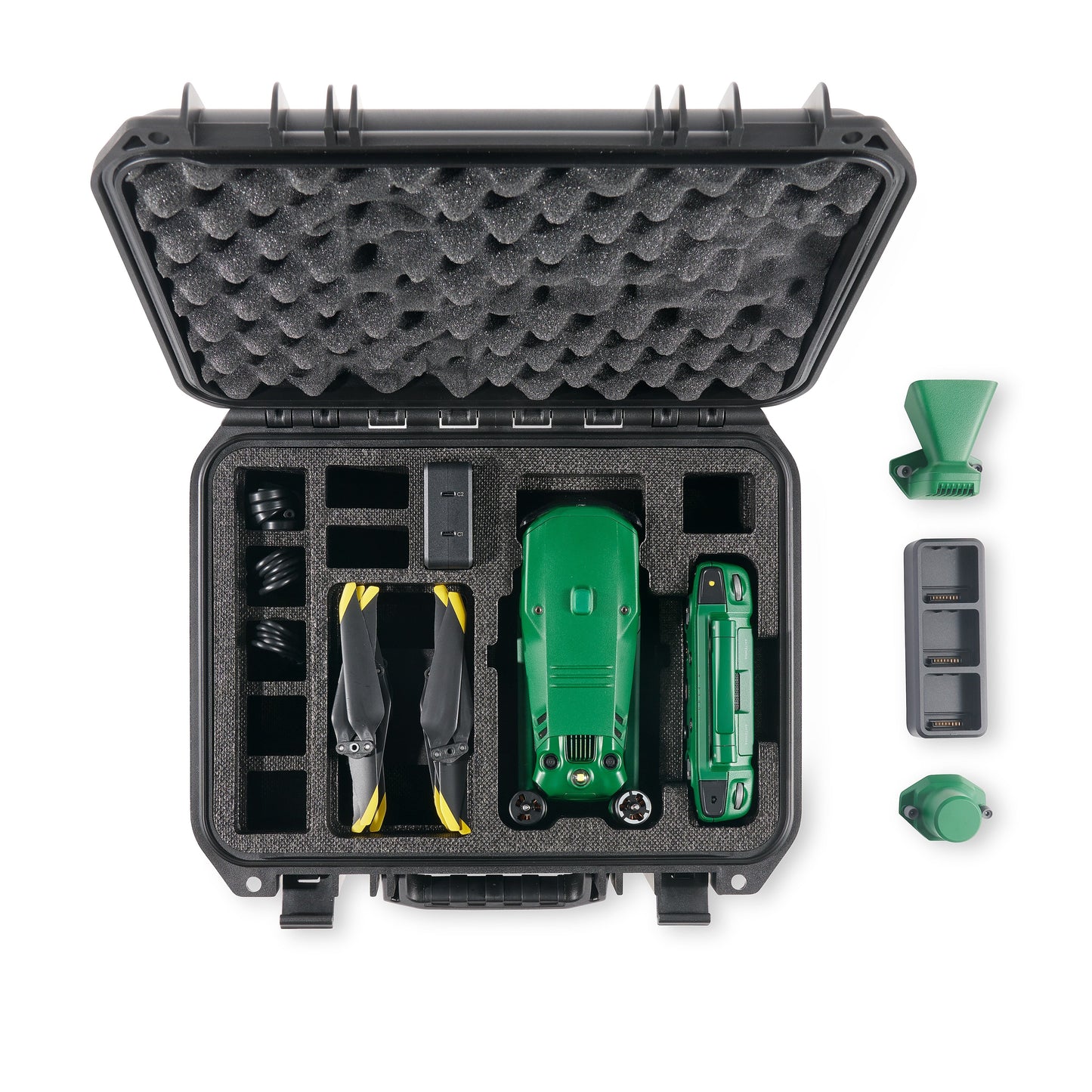
In the Box
- 1x Anzu Raptor T aircraft
- 1x Controller w/ built-in screen
- 1x Battery
- 1x Charging Station
- 1x RTK Module
- 1x Speaker
- 1x Charging Hub
- 1x Charging Station
- 1 Set Propellers
- 1x Hard Case
- Manuals

