


Understanding Drone Flight Path Planning Software: A Complete Guide for Professionals
If you're still manually flying missions or relying on guesswork to cover an area, you're not just wasting time—you could be compromising safety, compliance, and data quality. For professionals in industries like public safety, energy, agriculture, or surveying, drone flight path planning software has become an operational must-have.
This guide unpacks what flight planning software is, what it does, and how to use it effectively. From mission design to in-field execution and post-flight review, you’ll learn the core features, workflows, and tools that help teams run smarter, safer, and more consistent drone operations.
What Is Drone Flight Path Planning Software?
Drone flight path planning software allows you to pre-program your aircraft’s flight path before takeoff—transforming your drone from a manual tool into a precision-guided data collector. Whether you’re capturing high-resolution images for a 2D map or conducting a corridor inspection along a power line, planning software ensures consistency, efficiency, and safety.
At a high level, flight planning tools control:
- Waypoint Navigation – Set exact coordinates, altitude, flight speed, and camera actions
- Grid & Area Mapping – Define rectangular or polygonal survey zones with overlap and sidelap
- Geofencing – Restrict flight boundaries to avoid no-fly zones or sensitive areas
- Terrain Awareness / Terrain Follow – Maintain a consistent altitude above ground level using elevation models
- Failsafe Logic – Define what the drone should do if it loses signal or drops below critical battery thresholds
- Coverage Visualization – Preview real-time or simulated coverage maps to identify gaps before flying
- Export Formats – Generate mission files compatible with GIS, photogrammetry, or post-processing tools (e.g., KML, KMZ, CSV, shapefiles)
Flight planning isn’t just about flying hands-free—it’s about creating repeatable, auditable, and high-quality flight operations. As your missions grow in complexity or volume, using planning software becomes the foundation for scaling your drone program safely and professionally.
Benefits of Using Flight Planning Software
Flight planning software isn’t just a convenience—it’s the backbone of reliable drone operations. Whether you're managing a single aircraft or an entire fleet, these tools help you fly with purpose, precision, and accountability. Below are the key benefits that planning software provides across various mission types.
1. Precision and Consistency
Manual flying introduces variation—especially when missions are repeated over time or across multiple pilots. Planning software eliminates guesswork by automating flight paths, camera actions, and data collection parameters.
With pre-programmed missions, you can:
- Ensure consistent overlap, altitude, and framing across all flights
- Reduce variation between team members or shifts
- Collect high-integrity data that’s suitable for 2D mapping, 3D modeling, and long-term comparisons
This level of precision is critical in industries like construction, surveying, agriculture, and environmental monitoring where small deviations can lead to inaccurate measurements or missed data.
2. Time and Efficiency Gains
Planning once means you can fly many times without redoing the work. Once your flight parameters are set—such as altitude, speed, and payload triggers—the mission can be saved and reused, even across different sites or drones.
Efficiency benefits include:
- Faster pre-flight setup with reusable templates
- Automated payload triggers (no need to manually snap photos or switch modes)
- Shorter total mission time due to optimized flight paths and overlap control
This not only boosts field productivity but also reduces pilot fatigue and workload on repetitive tasks.
3. Enhanced Safety
Every flight has risk, but planning software helps reduce it by enforcing key safety boundaries and behaviors. Features like geofencing, terrain awareness, and automatic return-to-home help prevent accidents, especially in complex or crowded airspace.

Key safety advantages:
- Enforced altitude ceilings and no-fly zones
- Built-in failsafe behaviors (e.g., RTH on signal loss or low battery)
- Pre-mission simulations to visualize and flag hazards in advance
These features are particularly important for urban operations, infrastructure inspections, and BVLOS missions where manual recovery isn’t always an option.
Anatomy of a Flight Plan
Flight path planning software may look different depending on the platform you use—but most interfaces follow the same core structure. Whether you're flying an automated grid mission or a complex waypoint route, understanding what goes into a plan helps you avoid mistakes and collect better data.
Not sure what goes into a flight plan? Here’s a quick breakdown of the core elements every operator should set before launch.

Need help planning more precise missions? Ask the DSLRPros team.
Now that you’ve seen the key elements at a glance, let’s take a closer look at what each one means in practice—and how they affect mission success.
1. Area of Interest
Start by identifying the physical region your drone needs to cover. This might be a square grid for mapping a construction site, a polygonal shape to outline an irregular field, or a narrow corridor along a road or power line. The shape you choose should reflect the purpose of the mission and the geography of the site. Many platforms also allow you to upload predefined shapefiles, KMLs, or GeoJSON boundaries from GIS platforms—useful for complex or multi-parcel jobs.
2. Altitude and Flight Speed
Next, you’ll determine how high and how fast the drone will fly. Altitude can be set as above ground level (AGL) or above mean sea level (AMSL), depending on how the software handles elevation. For missions involving uneven terrain, enabling terrain-follow mode ensures the drone maintains a consistent height relative to the ground. Flight speed must be balanced against image clarity and shutter speed—slower speeds usually yield sharper images and better data quality, especially in low light or windy conditions.
3. Overlap and Sidelap Settings
Overlap refers to how much of each image overlaps with the previous and adjacent images. For most photogrammetry missions, 75% front overlap and 70% side overlap is considered a safe baseline. Higher overlap is recommended for 3D reconstructions or complex surfaces, but it increases flight time and data volume. Setting this correctly is critical to avoid gaps or unusable image sequences that can’t be stitched during post-processing.
4. Camera or Payload Triggers
You’ll also configure when and how your drone’s payload captures data. This could be at fixed time intervals, distance-based intervals (e.g., every 20 meters), or at specific waypoints. Advanced missions may require additional automation—like triggering thermal cameras to change modes mid-flight or rotating gimbals to capture oblique angles. These payload actions ensure you’re collecting the right type of data in the right locations.
5. Estimated Outputs
Before launch, most software tools will generate a mission estimate: how long the flight will take, how many images will be captured, how many batteries you’ll need, and how much area will be covered. This preview helps you assess whether your plan is practical or needs refinement. It’s especially helpful for multi-battery or multi-phase operations, where efficiency and power management are critical.
Understanding and fine-tuning these components doesn’t just improve data quality—it also helps reduce wasted flights, battery depletion, and unnecessary post-processing corrections. In high-stakes operations, that can mean the difference between actionable insights and costly do-overs.
Core Features and Planning Modes
Flight planning software isn’t just about drawing a line on a map. Most platforms support multiple planning modes and intelligent automation tools that match different mission profiles. Here are the most common and critical features to understand:
Waypoint Navigation
This mode lets you define a custom route by placing individual waypoints on a map. Each waypoint can include specific flight behaviors and sensor actions.

- Assign unique settings for altitude, speed, gimbal angle, or camera trigger
- Ideal for detailed inspections, such as wind turbines, towers, or bridges
- Example: Fly a square path around a telecom tower, pausing at each corner to capture close-up photos from different heights
Grid and Area Mapping
Used for creating consistent image coverage of wide, flat areas, this mode is perfect for photogrammetry, orthomosaics, and 3D models.
- Set grid density, overlap (e.g., 75/70), and altitude for uniform data capture
- Best for large-area mapping: agriculture, construction, land development
- Example: A construction crew flies weekly grid missions over a job site to generate up-to-date terrain models and track excavation volume
Corridor Mapping
This planning mode is optimized for long, narrow assets or routes—where standard grids would waste time and battery.
- Follows a linear flight path with side-to-side camera coverage
- Commonly used in utility inspection, road monitoring, or railway scanning
- Example: An energy company flies a corridor mission to monitor 10 km of powerline for damage or vegetation encroachment
Terrain Follow
Instead of flying at a fixed height, terrain follow keeps the drone at a constant distance above the ground using elevation data.
- Adjusts altitude in real-time to maintain consistent GSD
- Essential for mapping hilly areas, mines, or uneven terrain
- Example: A survey team flies over a valley and ridge system, using terrain follow to maintain 60 meters AGL across elevation changes
Geofencing and No-Fly Zones
Digital fences can be drawn to block flight into sensitive or restricted airspace, either manually or using preloaded data.
- Prevents accidental intrusion into airports, prisons, or other no-fly areas
- Helps ensure compliance with FAA or local regulations
- Example: A team mapping near a heliport uses geofencing to create a buffer zone that stops the drone from crossing into restricted airspace
Failsafe Behaviors
Unexpected issues—like signal loss or low battery—require fast decisions. Failsafe settings tell your drone what to do automatically.

- Return to home (RTH), hover in place, or land immediately
- Useful for BVLOS, urban missions, or complex job sites
- Example: A drone inspecting solar panels across a large field is set to RTH when battery drops below 20%
Payload Actions
More than just flying, mission plans can include commands for your sensors and gimbals to ensure the right data is captured.
- Control shutter timing, zoom level, gimbal tilt, or sensor mode
- Supports RGB, thermal, LiDAR, and multispectral workflows
- Example: During a roof inspection, the drone switches from visual to thermal view and rotates the gimbal down at each waypoint to capture both heat loss and structural detail
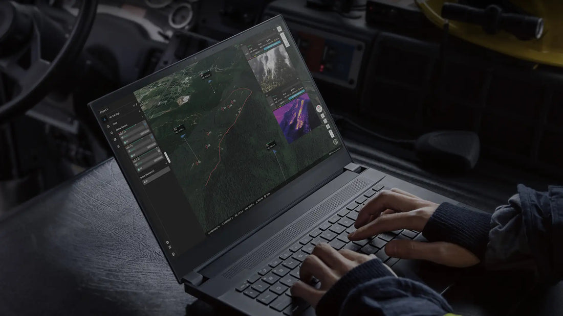
Live Monitoring and Mid-Mission Adjustments
Some platforms allow you to actively monitor flights and make changes in real time—ideal for unpredictable or time-sensitive missions.
- Pause/resume, change altitude, adjust camera settings mid-flight
- Valuable in SAR, wildlife tracking, or tactical scenarios
-
Example: A search-and-rescue team reroutes the drone toward a heat signature spotted in the live thermal feed, overriding the original path
How to Use Drone Planning Software
Planning software doesn’t just draw a line on the map—it guides every phase of your drone mission, from setup to execution and post-flight review. While each platform has its own interface, most follow the same five-step process.

1. Pre-Mission Setup
Start by selecting the mission type (e.g., mapping, inspection, thermal search) and identifying your target area. Some tools let you import maps, DSMs, or previous flight logs. You’ll also choose which drone and payload you’re using, which determines available flight options and data settings.
2. Define Flight Parameters
Next, set altitude, speed, image overlap, and other core parameters. For mapping missions, you’ll likely choose a grid layout with 70–85% overlap. For inspections, you’ll assign specific waypoints with camera angles. This step often includes payload configurations like shutter speed, capture interval, and gimbal tilt.
3. Set Safety and Compliance Conditions
Before launching, set altitude ceilings, geofences, and return-to-home behavior. Confirm airspace permissions (e.g., LAANC if flying in controlled airspace) and review hardware diagnostics like battery life, firmware status, and GPS signal. Many platforms include a pre-flight checklist or flight simulation tool.
4. Execute and Monitor the Mission
Once airborne, the software takes over—flying the drone according to your plan. Some platforms allow real-time adjustments, such as pausing, rerouting, or manually triggering the camera. Throughout the flight, telemetry data is displayed for tracking drone status, signal strength, and environmental conditions.
5. Post-Flight Workflow
After landing, your imagery and metadata can be reviewed and exported. Some systems automatically upload logs and media to the cloud, while others allow manual transfer to photogrammetry or GIS software. You’ll also be able to inspect flight paths, check mission success rates, and tag any issues for further review.
Wait—Do Drone Operators Need to File FAA Flight Plans?
Not usually. Traditional FAA flight plan filing (like what's outlined in this FAA guide) is designed for manned aircraft flying under Visual Flight Rules (VFR) or Instrument Flight Rules (IFR).

Under Part 107, drone pilots aren’t required to file flight plans with the FAA. Instead, they should:
- Use LAANC to get airspace authorization near controlled airports
- Log all flights and telemetry using tools like Airdata or DroneDeploy
- Follow safety protocols and maintain visibility of their aircraft unless authorized for BVLOS operations
If you're flying beyond visual line of sight (BVLOS) or conducting public agency operations, additional filing or waivers may apply. But for most commercial drone missions, software-based flight planning and automated logs meet both operational and compliance needs.
Matching Mission Types to Planning Features
Not all missions are created equal—and neither are the tools you’ll need to fly them. A drone flight plan for a 3D construction survey has very different requirements than a thermal search-and-rescue operation or a utility corridor inspection. The key to choosing the right software and settings is understanding how mission type affects flight planning priorities.
Here’s a breakdown of common mission types and the features they typically require:
| Mission Type | Recommended Features | Why It Works |
|---|---|---|
| 2D Mapping / Surveying | Grid planning, overlap control, terrain follow | Delivers consistent ground sampling and complete image coverage for orthomosaics. |
| Inspection (e.g., buildings, towers) | Waypoints, gimbal angle control, manual override | Allows precise flight path control and repeatability over structural features. |
| Search & Rescue / Public Safety | Corridor mapping, thermal payload control, live rerouting | Enables quick response over roadways, coastlines, or disaster zones—especially with limited visibility. |
| Agricultural Monitoring | Multispectral sync, NDVI capture, terrain-following | Optimizes crop health data by triggering sensors at precise altitudes and lighting conditions. |
| Utility & Energy Infrastructure | Corridor mode, terrain awareness, BVLOS flight logging | Supports long linear inspections and ensures compliance in regulated environments. |
| Disaster Response | Offline planning, rapid map processing, short takeoff time | Useful in low-connectivity environments where speed and simplicity are critical. |
Quick Reference: Software That Supports These Features
These software platforms support many of the planning modes mentioned above. Always confirm compatibility with your drone model and payloads.
| Software | Supports |
|---|---|
| DJI FlightHub 2 | Real-time mission planning, fleet tracking, terrain awareness, and map-based operations |
| DJI Terra | Post-flight 2D/3D reconstruction, LiDAR point cloud processing, and volume measurement |
| DroneDeploy | Grid planning, NDVI, volumetrics, annotations |
| FlytBase | BVLOS scheduling, telemetry streaming, automated missions |
| Airdata | Pre-flight checklists, flight logging, maintenance tracking |
| Pix4Dreact | Offline mission planning, fast orthomosaic generation |
Smarter Planning, Safer Missions
Drone flight planning software is no longer an optional tool. It’s a mission-critical part of any professional workflow. Whether you're flying a single drone for land surveying or managing a fleet for utility inspections, planning software enables consistency, accountability, and safer operations.
With the right tools, you can capture better data the first time, minimize risk and downtime, maintain regulatory compliance, and scale your operations with less friction. Most importantly, they allow you to focus on the mission, not micromanaging every movement of your drone. Understanding the core features and workflows of flight path planning software gives you the confidence to take on more complex jobs with precision and control.
Need help choosing the right platform for your missions?
DSLRPros can help match your hardware and mission goals to software tools that fit—whether you’re building a program from scratch or optimizing what you already have.

