


Drone Software for Streamlined Aerial Operations
As drone technology advances, software has become essential for transforming raw flight data into actionable insights. At DSLRPros, we offer a full range of drone software solutions designed to support professionals in mapping, surveying, inspections, agriculture, and emergency response.
Whether you're managing a construction site or analyzing crop health, the right software platform helps make your drone operations more precise, efficient, and data-driven. Our collection includes top options like DJI FlightHub 2, DJI Terra, Airdata, Autel Mapper, and the full PIX4D suite—available in perpetual, annual, or monthly plans to fit any operational need.
Featured Drone Software at DSLRPros
Autel Mapper: Built for mapping and survey professionals, Autel Mapper delivers high-accuracy 3D models and geospatial data outputs, optimized for Autel drones.
DJI FlightHub 2: A cloud-based platform for real-time drone fleet coordination and remote mission planning. Ideal for project managers and field teams.
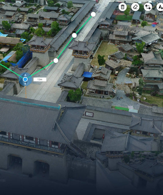
DJI Terra: Convert drone-captured imagery into high-resolution 3D reconstructions or 2D orthomosaic maps—ideal for construction, infrastructure, and agriculture.
Airdata UAV: Track flight safety, maintenance, and compliance with powerful post-flight analytics. Airdata is trusted by drone pilots for reliable operational insights.
PIX4D Suite
-
PIX4Dmapper: Photogrammetry software that turns drone images into precise 3D maps and models.
-
PIX4Dmatic: Handles large datasets for scalable mapping projects.
-
PIX4Dfields: Offers quick crop scouting and NDVI mapping for agricultural monitoring.
-
PIX4Dcloud: Online platform for drone data processing and team collaboration.
-
PIX4Dsurvey: Integrates point cloud data into CAD workflows, bridging the gap between photogrammetry and land surveying.
-
PIX4Dreact: Fast, 2D mapping software for emergency response and disaster assessment.
Who Uses Drone Software—and Why
Construction & Infrastructure
Software like DJI Terra and PIX4Dmatic allows for precise topographic mapping, volumetric calculations, and progress tracking. These tools improve safety, accuracy, and documentation across construction sites.
Agriculture
Tools like PIX4Dfields give farmers detailed insights into crop health, enabling better decision-making for irrigation, fertilization, and pest control. Aerial maps can highlight problem areas before they impact yield.
Public Safety & Emergency Response
PIX4Dreact enables first responders to create up-to-date maps of disaster zones. With fast image processing, responders can plan and act more effectively when time is critical.
Energy & Utilities
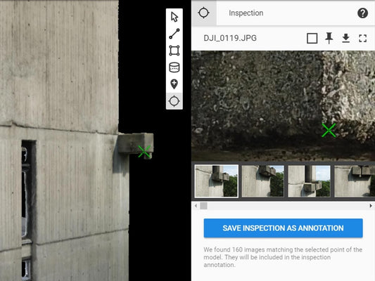
DroneDeploy and Airdata simplify inspections of wind turbines, power lines, and solar farms. These platforms provide detailed visuals and logs to help detect issues while reducing the need for risky manual work.
Real Estate & Urban Planning
Drone software enables high-resolution modeling of properties and cityscapes. These visual tools are ideal for planning developments or showcasing listings.
Mining & Quarries
Use drone photogrammetry tools like PIX4Dmatic to manage stockpile inventory, monitor site changes, and improve safety in mining environments.
Environmental Monitoring
Track deforestation, monitor wildlife habitats, or assess coastal erosion using drone mapping software. Environmental professionals rely on this data to guide conservation decisions.
Insurance & Asset Inspection
Drone inspections help assess property damage quickly and accurately. With high-resolution images and 3D models, adjusters can make informed evaluations remotely.
Subscription Plans to Match Your Workflow
At DSLRPros, we offer flexible licensing options—monthly, annual, and perpetual—to support both short-term missions and long-term operational needs. Whether you're a large enterprise or a solo operator, we can recommend a solution that fits your goals and budget.
Why Buy Drone Software from DSLRPros?
DSLRPros isn't just a retailer—we’re a trusted advisor for professionals in aerial data collection. Our team provides personalized guidance on selecting the right drone software for your workflows. From photogrammetry and asset inspection to fleet management, we help you get the most value from your drone investment.
Explore Drone Software at DSLRPros
Take your drone operations to the next level. Browse our curated selection of drone mapping software, inspection tools, and data processing platforms today. Whether you’re surveying land, analyzing infrastructure, or conducting precision agriculture, DSLRPros has the software to make it happen.
Choosing the Right Drone Data Platform
Not sure whether DJI FlightHub 2 or Airdata is the best fit for your operations? Our latest article breaks down the key differences between these two leading platforms, helping you determine which solution aligns with your operational needs. Read the full comparison here.
Or, if you're comparing PIX4D, DroneDeploy, and DJI Terra, check out this guide: What Is the Difference Between PIX4D, DroneDeploy, and DJI Terra?.

