SIRAS Drone Power-Up: Individual State Maps Now Available!
Share

- Streamline missions with individual state maps with SIRAS Firmware Update 1.16.49
- Use only the state maps relevant to your operations, saving storage space.
- Maps displayed on the remote screen, and you can switch between pre-loaded maps.
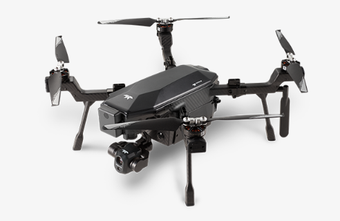
The Teledyne FLIR SIRAS drone just got a massive boost in the latest firmware update. You can now download state maps, making it even more versatile and efficient for all your missions.
Before, you could only download maps by region. That was limiting, especially if you used the drone in one state or a specific area, since the regional map would take up a large amount of memory space. Well, we can say goodbye to that now.
By offering individual state map downloads, Teledyne has addressed the issue of regional map downloads. Now, if you primarily use the SIRAS in a specific state, you no longer have to clutter your precious storage with maps you don't need. Instead, you can download and save only the state maps that are relevant to your operations, streamlining the storage on your memory card.
CRITICAL Note: The company has also issued a safety notice stating that there is a firmware programming issue in the SIRAS system, which may disrupt communication between the remote controller and the aircraft. As a result, all controllers with firmware version 1.16.46 and earlier could be affected. The drone maker is strongly advising all users to promptly update their firmware.
In the following sections, we will guide you through the process of accessing and downloading the maps, updating your drone with the new maps, utilizing the maps on the remote screen, look into the benefits and considerations of these updates.
Accessing the FLIR SIRAS Drone Maps and Firmware Updates
To take advantage of the new individual state map downloads and firmware updates for your Teledyne FLIR SIRAS drone, follow these simple steps:
Step 1: Navigate to FLIR website
One of the key features of the SIRAS drone is its offline capabilities. Unlike many other drones that rely on real-time internet connectivity for map data, the SIRAS operates completely offline. This means that to access maps for your flights, you need to head over to FLIR website. Here, you'll find not only the firmware updates but also the newly available individual state maps.
So go ahead and fire up your preferred web browser and navigate to the SIRAS product page.

Once you're on the website, locate the downloads tab. This is where you'll find all the necessary files, including the firmware updates and the individual state maps.
Step 2: Location of the Firmware Updates and Individual State Maps
After clicking on the downloads tab, you'll be presented with a list of available downloads. Look for the firmware updates and the individual state maps.

Step 3: Download and Save the Desired State Map Files
To download state maps, just click on the state you want and the file will start downloading to your computer. Once the download finishes, you can transfer the map files to the micro SD card.
Step 4: Transfer to your Micro SD Card
Insert the micro SD card into your computer or use a card reader. Locate the FlyWatch directory on the micro SD card.

Within the FlyWatch directory, you'll find a subdirectory called "map."
Next, copy the downloaded map file into the map subdirectory in the FlyWatch folder.
This ensures that the map is properly saved on the micro SD card and can be accessed by your Teledyne FLIR SIRAS drone.
Once the map is fully transferred to the micro SD card, safely eject the memory card from your computer or card reader. Then, insert the micro SD card back into the controller of your drone.
Step 5: Power on the Controller and Establish a GPS Connection
With the map files are stored on the micro SD card, it's time to power on the controller. After this, establish a GPS connection with your Teledyne FLIR SIRAS drone. You will see the maps displayed on the bottom right-hand corner of the remote screen. This confirms that the new maps have been successfully updated on your Teledyne FLIR SIRAS drone.
Congratulations! You have now successfully updated your drone with the new state maps. In the next section, we will explore how to utilize these maps on the remote screen to enhance your flying experience.
Utilizing the Maps on the Remote Screen
The remote screen provides a convenient and user-friendly interface for accessing and interacting with the maps during your drone missions. In this section, we will cover how to display the maps, expand them to full-screen mode, zoom in to explore flight path details, recenter the map, and switch between pre-loaded maps.
Displaying the Maps on the Remote Screen
Once you have established a GPS connection and see the familiar SIRAS interface on your remote screen, you will notice the maps in the bottom right-hand corner. You’ll use these maps to explore and navigate the drone's flight path.
To see the maps, just tap on the map icon in the bottom right corner of the remote screen. This will open the maps and let you interact with them.
Expanding the Map to Full-Screen Mode
To see the drone's surroundings better and get more detailed information, just make the map full-screen. Open the map on the remote screen, tap it, and it will automatically enlarge to fill the whole screen. This bigger view will give you a clear and complete visual of the area you're flying in, helping you stay aware of your surroundings during the mission.
Zooming In and Exploring Details of the Aircraft's Flight Path
To examine specific areas or details along the flight path, the SIRAS drone allows you to zoom in on the map. To zoom in on the map, use the familiar two-finger pinch gesture. Put two fingers on the remote screen and bring them closer together. When you zoom in, the map will get bigger, showing more detailed information like landmarks, roads, and interesting places. This helps you carefully study the surroundings and make smart choices during your mission.
Recentering the Map and Switching Between Pre-loaded Maps
During a mission that involves covering multiple regions or states, you may need to recenter the map or switch between pre-loaded maps. Recentering the map is simple. On the top right of the screen, there's a center icon. When you tap it, the map will adjust so that the drone's current location is in the middle of the screen. This helps you keep track of where your drone is.
If you have multiple state maps on your micro SD card, you can easily switch between them using the maps icon next to the center icon. Just tap the maps icon, and you can toggle between the different maps you've loaded. This lets you smoothly switch between regions or states while you're on your mission. This flexibility enhances your operational efficiency and adaptability.
By utilizing these map features on the remote screen, you can effectively navigate, explore, and monitor the drone's flight path, ensuring a successful and informed mission.
In the next section, we will discuss the benefits and considerations of the new individual state map downloads, including downloading multiple maps for missions across different states, managing storage space on the memory card, and highlighting the critical nature of firmware updates for optimal drone performance.
Benefits of the Firmware Update
Downloading Multiple Maps for Missions Across Different States
One of the significant benefits of the new Teledyne FLIR SIRAS drone update is the ability to download individual state maps. Unlike the previous regional map downloads, which took up unnecessary space on the memory card, you can now select and download maps specific to the states where you'll be conducting missions. If you frequently operate in multiple regions or states, this feature allows you to have all the necessary maps conveniently stored on your drone's memory card.
Removing Maps to Save Space and Storage on the Memory Card
Flexibility is a key advantage of the Teledyne FLIR SIRAS drone. While you can download multiple maps onto the micro SD card for missions across different states, you also have the option to remove maps when they are no longer needed. This capability helps you save valuable space and storage on your memory card, ensuring that you can efficiently manage your drone's resources and accommodate new map downloads as required.
The SIRAS drone is already an impressive piece of technology, and firmware updates are essential for enhancing its performance and addressing any potential issues. You can bookmark the download page for easy access to the latest firmware releases, enabling you to keep your drone up to date and take full advantage of the improved capabilities they offer.
Nature of Firmware Updates for Drone Performance
Firmware updates are not mere optional enhancements for the Teledyne FLIR SIRAS drone; they are critical for ensuring optimal performance. These updates contain crucial improvements and bug fixes that enhance the drone's functionality, stability, and reliability. Neglecting firmware updates can result in missed opportunities to benefit from important advancements and potentially compromise the performance and safety of your drone. Therefore, it is vital to prioritize and regularly check for firmware updates to guarantee the best possible experience and maximize the potential of your SIRAS drone.

Update that Makes it Easier to Chart Your Course
Teledyne FLIR's latest update for the SIRAS drone revolutionizing its capabilities. Users can now optimize performance by downloading specific state maps and stay up to date with the latest firmware releases. This enables streamlined missions, precise navigation, and convenient switching between pre-loaded maps. By embracing these advancements, users can experience enhanced offline capabilities, ensure top-notch performance, and explore new horizons with confidence. Don't miss out on these improvements—visit FLIR.com, download the necessary maps, and stay updated with the latest firmware releases for an exceptional flying experience with your Teledyne FLIR SIRAS drone.


