
DSLRPros Autel Evo II Pro DroneDeploy Mapping Package
Vendor Part Number
102001059
- All In One Professional Mapping Solution
- 1” Sensor Captures 20MP Still, 6K Video
- Long Flight Times For Large Area Mapping
- 360 Degree Obstacle Avoidance
- Easily Create Orthomosaic Maps, Contour Maps, 3-D Models, and More
- Accurately Measure Distance, Volumes, and Area
OR


The DSLRPros Autel Evo II Pro DroneDeploy Mapping Package enjoins one of the world's most advanced small flight systems with enterprise-level mapping and flight software. Pairing the Autel EVO II Pro with DroneDeploy software gives professionals an all in one solution for data capture, processing, and analysis. Whether you work in construction, agriculture, or industrial inspection, this is the package that will make your flights easier and more efficient.
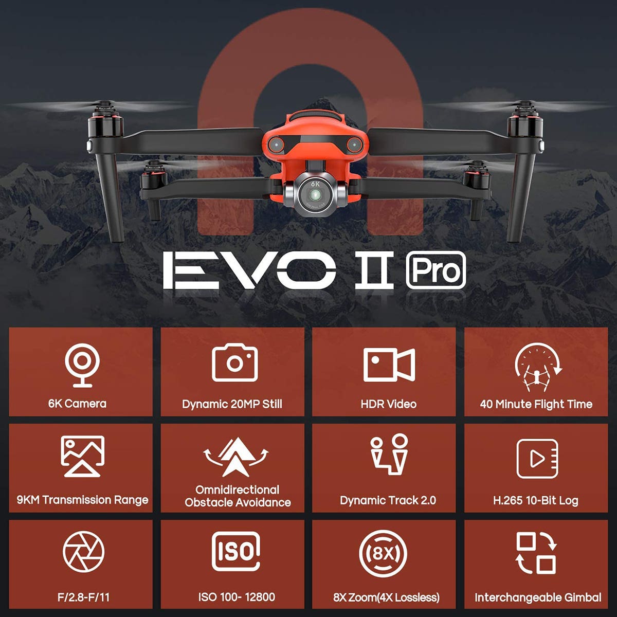
Autel's EVO II Pro is a powerful and compact flight system. This drone weighs 2.6 pounds and has collapsible arms for quick and easy storage. Software and technology within the craft give the EVO II Pro to have long flight times, 360-degree obstacle avoidance, and beyond High Definition video capture. The integrated camera system offers users 3X lossless zoom and 8X digital zoom, all while capturing 6K video and 20 Megapixel images.
Included with this package is DroneDeploy's mapping and flight management software. Trusted by thousands of businesses and individuals, DroneDeploy uses cloud-based computing to plan and manage autonomous flights, generate maps and reports with survey-grade accuracy, share information easily amongst team members.
Beyond High-Quality Imaging
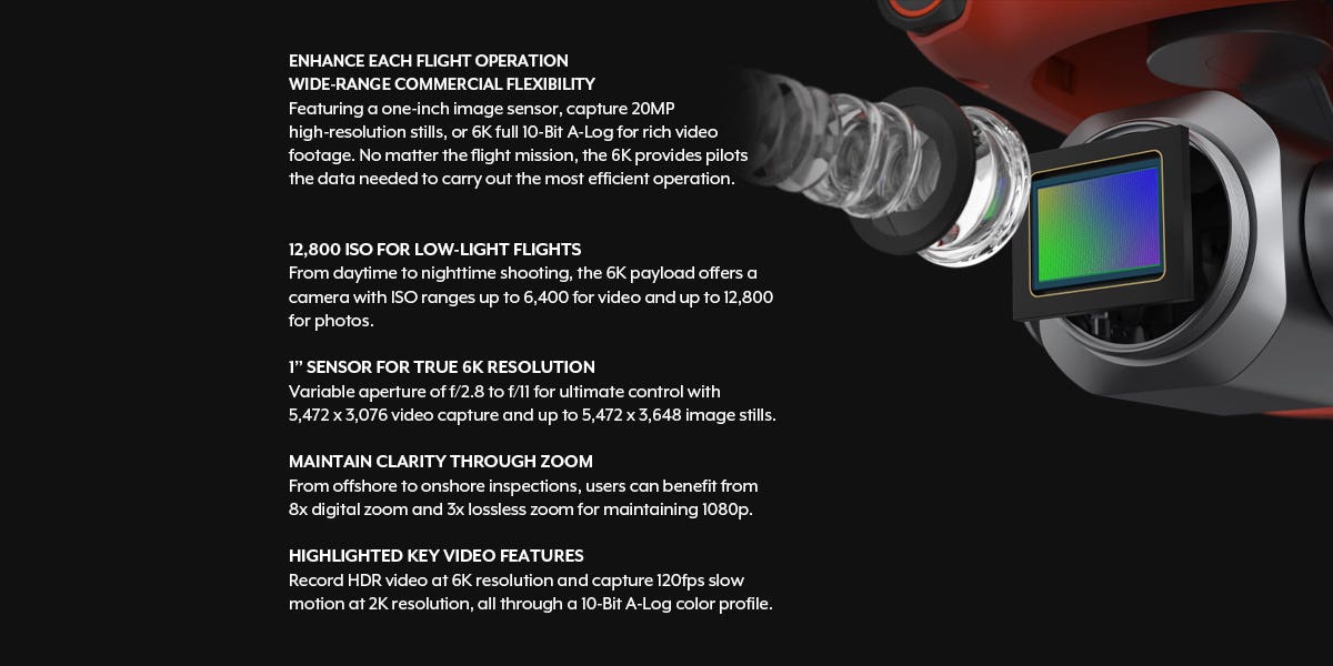
While many crafts are capable of shooting 4K video, few are able to record 6K. The EVO II Pro's 1 inches CMOS sensor gives users 6K video with high dynamic range, low noise, and high zoom capabilities. The EVO II Pro works amazingly well in low-light settings (including night flights) due to its' automatic aperture that functions between f/2.8 and f/11. The camera boasts a very high ISO of 6,400 for video and 12,800 for still images.
The EVO II PRO is capable of amazing dynamic range due to its' 10-bit sensor. Capable of capturing 1 billion colors, the video and images have never been more detailed with a craft of this size. The EVO II also supports 4K HDR recording offering increased contrast and color. This allows mappers to retain rich detail in shadows and low light environments.
Having access to this much high-quality data enables operators to generate the most detailed maps and imaging while maintaining a safe distance from potential hazards.
Amazing Flight Capabilities
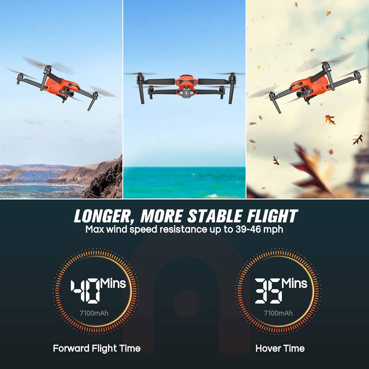
With the Autel EVO II Pro's high-efficiency motors, tough propellers, and sophisticated flight software make this craft capable of flying for 40 minutes. The EVO II Pro also has a maximum flight speed of 45 MPH, and maximum wind resistance of 39 MPH. This enables users to fly in a variety of conditions and collect data with minimal down-time. The advanced digital transmission enables live image transmission from up to 5.5 miles away. This increased signal strength allows you to conduct flights in open areas, urban settings, or offshore.
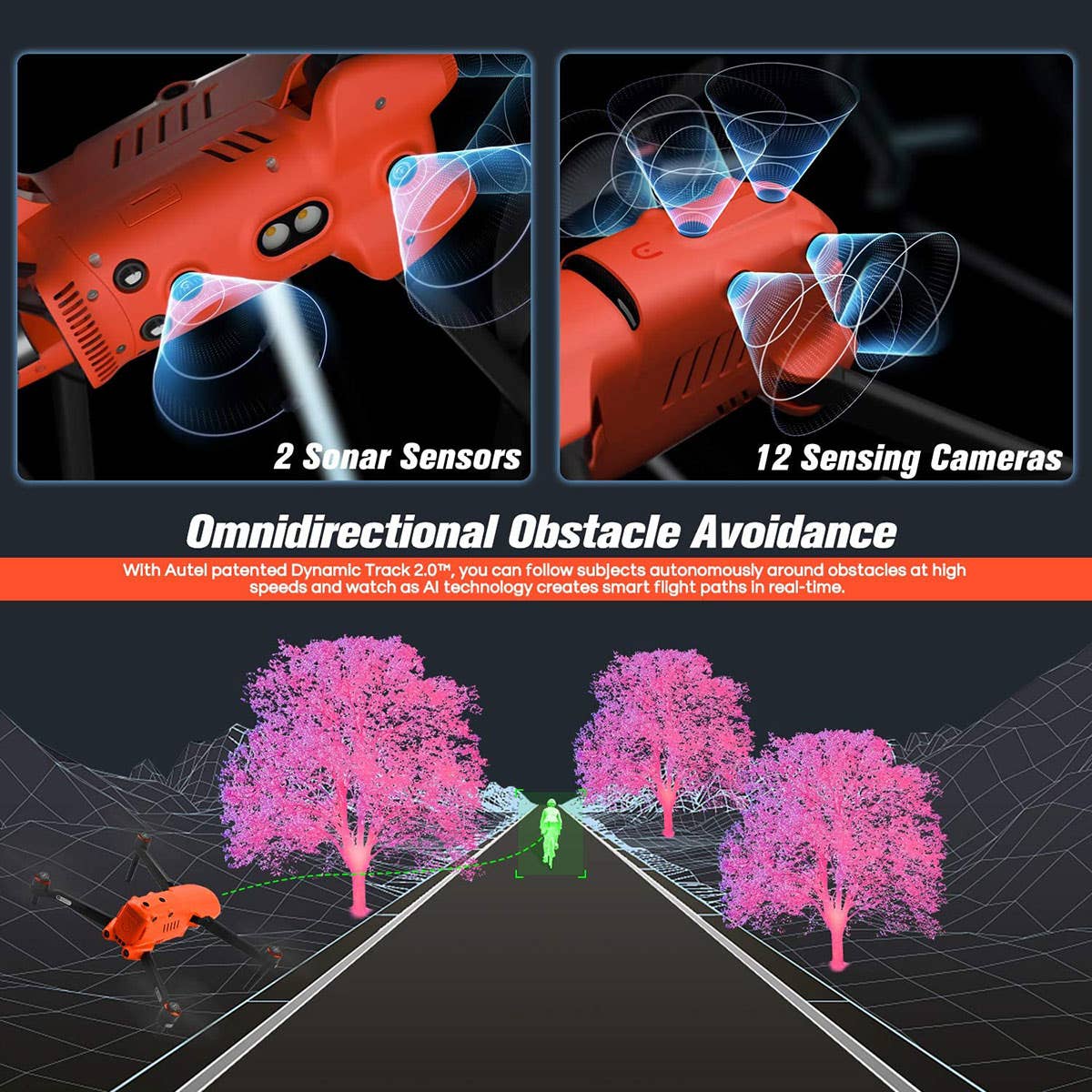
Advanced Obstacle Avoidance
The automated functions on this craft set it apart from its' competitors.
The Autel EVO II Pro uses an array of sensors and Artificial Intelligence software to keep your craft safe while in flight. 12 imaging sensors, 2 sonar sensors, and the EVO II Pro's gimbal sensor, ultrasound, and IMUs work together to generate 3D maps in real-time so that the EVO II can detect obstacles from up to 95 feet away. Powerful software then calculates the safest way to avoid collision and guides itself to safety. Using Dynamic Track 2.0 and this obstacle avoidance technology, the EVO II Pro can automatically track an object, predict trajectories, and avoid obstacles completely by itself.

Mapping Software For Industry Innovators
Trusted by more than 5,000 companies and professionals, DroneDeploy is the industry-leading drone data solution. DroneDeploy's software is useful in all aspects of drone flight. From preflight planning, in-flight data collection, to post-flight data analysis, DroneDeploy makes every aspect of flying your drone easier and more efficient.
Using DroneDeploy, you can plan your flight and make takeoff, flight, and landing completely automated and repeatable to check progress over time. Flight data is collected in real-time and uploaded to cloud-based servers giving your entire team access to information as it is collected. Finally, DroneDeploy's powerful software can easily generate 3D maps, compare designs to final products, calculate volumes and areas, and even automate counting of agricultural products and supplies.
This amazing software is an invaluable tool for enterprise-level professionals working in construction, survey, mining, inspection, and agriculture.
Camera
- Image Sensor: 1" CMOS
- Pixels: 20MP
- Perspective: 82°
- Lens: EFL: 28.6 mm | Aperture: f/2.8–f/11| Focus Distance: 1m to any distance (with autofocus mode)
- ISO Range: Video: 100-6400 (auto) | Photo: 100-12800 (auto)
- Zoom: 1-8x (Max 3x lossless)
- Still Photography Modes: Single Shot | Burst shooing: 3/5 frames | Automatic Exposure Bracketing (AEB):3/5 bracketed frames at 0.7 EV Bias
- Timelapse: JPG:2s/5s/7s/10s/20s/30s/60s | DNG:5s/7s/10s/20s/30s/60s
- HyperLight: support (under 4K JPEG format)
- Long Exposure: Max 8s
- HDR imaging: (under 4K JPEG)
- Still Photography Resolution: 8000*6000 (4:3) | 7680*4320 (16:9) | 4000*3000 (4:3) | 3840*2160 (16:9)
- Video Format: MP4 / MOV (MPEG-4 AVC/H.264, HEVC/H.265)
- Video Resolution: 6K 5472*3076 p30/p25/p24 | 4K 3840*2160 p60/p50/p48/p30/p25/p24 | 2.7K 2720*1528 p120/p60/p50/p48/p30/p25/p24 | 1080p 1920*1080 p120/p60/p50/p48/p30/p25/p24
- Max Bitrate: 120Mbps
Aircraft
- Takeoff Weight: 2.6 lbs (1191 g)
- Max Takeoff Weight: 4.4 lbs (2000 g)
- Diagonal Wheelbase: 15.6 inches (397 mm)
- Aircraft Battery: 7100 mAh
- Max Flight Time (standard): 40 min
- Max Hovering Time (standard): 35 min
- Max Level Flight Speed (Standard): 45 mph (20 m/s) (Ludicrous)
- Max Ascent Speed: 18 mph (8 m/s) (Ludicrous)
- Max Descent Speed: 9 mph (4 m/s) (Ludicrous)
- Max Takeoff Altitude: 4.3 miles (7000 m)
- Max Wind Resistance: Force 8 wind
- Operating Environment Temp: 32-104°F (0-40°C)
- Working Frequency (2.4G): 2.4~2.4835GHz
- Transmission Power (2.4G): 2.4~2.4835GHz | FCC: ≤26 dBm | ISED: ≤26 dBm | CE: ≤20 dBm | RCM: ≤20 dBm | SRRC: ≤20 dBm
- Hover Precision: Vertical: ± 0.02m (with visual positioning in normal operation) | ± 0.2m (with GPS in normal operation) | Horizontal: ± 0.02m (with visual positioning in normal operation) | ± 0.2m (with GPS in normal operation)
Sensing System
- Sensing System Type: Omnidirectional Binocular Sensing System
- Forward: Accurate Measuring Range: 0.5 - 20m | Detection Range: 0.5 - 40m | Effective Sensing Speed: < 15 m/s | FOV: Horizontal: 60°, Vertical: 80°
- Backward: Accurate Measuring Range: 0.5 - 16m | Detection Range: 0.5 - 32m | Effective Sensing Speed: < 12 m/s | FOV: Horizontal: 60°, Vertical: 80°
- Upward: Accurate Measuring Range: 0.5 - 12m | Detection Range: 0.5 - 24m | Effective Sensing Speed: < 6 m/s | FOV: Horizontal: 65°, Vertical: 50°
- Downward: Accurate Measuring Range: 0.5 - 11m | Detection Range: 0.5 - 22m | Effective Sensing Speed: < 6 m/s | FOV: Horizontal: 100°, Vertical: 80°
- Sides: Accurate Measuring Range: 0.5 - 12m | Detection Range: 0.5 - 24m | Effective Sensing Speed: < 10 m/s | FOV: Horizontal: 65°, Vertical: 50°
- Service Environment: Textured/patterned ground and adequate illumination (> 15 lux, normal indoor environment with fluorescent lamp on) | Upward: diffuse reflecting surface with reflectivity above 20% (wall, tree, human, etc.) | Downward: textured/patterned ground and adequate illumination (> 15 lux, normal indoor environment with fluorescent lamp on) | Upward: diffuse reflecting surface with reflectivity above 20% (wall, tree, human, etc.)
Gimbal
- Operation Range: Pitch: -135° to +45° | Yaw: -100° to +100°
- Operation Range: Pitch: -90° to +30° | Yaw: -90° to +90°
- Stability: More Stable with 3 Axis
- Max Control Speed (Tilt): 300°/s
- Angular Vibration Range (°): ±0.005°
Remote Controller and Transmission
- Max Signal Transmission Distance: 9km FCC, 5km CE
- Working Frequency (2.4G): 2.4~2.4835GHz
- Transmission Power (2.4G): 2.4~2.4835GHz | FCC: ≤26 dBm | ISED: ≤26 dBm | CE: ≤20 dBm | RCM: ≤20 dBm | SRRC: ≤20 dBm
- Real-Time Transmission Quality: 720p@30fps / 1080p@30fps
- Max Bitrate of Real-time Transmission: 40Mbps
- Remote Controller Battery: 5000mAh
- Operating Hours: 3h
- Charging Time: 2h Fast Charging
- Display: 3.26-inch OLED screen | 854 (W)*480 (H) pixels | Preview video without the need for connecting to a mobile phone
Battery
- Battery (mAh): 7100mAh
- Voltage (V): 11.55
- Transmission Power (2.4G): 13.2
- Battery Type: LiPo 3S
- Battery Energy: 82Wh
- Weight (g): 365
- Charging Temperature Range (°C): 5~45℃
- Storage Temperature & Humidity: -10~30℃,65±20%RH
- Recommended Storage Temperature: 22~28℃
- Max Charging Power Consumption (W): 93W
- Charging Time: 90min
Charger
- Input: 100-240 V, 50/60 Hz, 1.5A
- Output: 13.2 V ⎓ 5 A | 5V⎓3A 9V⎓2A 12V⎓1.5A
- Voltage: 13.2 ± 0.1 V
- Rated Power: 66 W
APP
- iOS: Autel Explorer
- Android: Autel Explorer
Storage
- SD Storage: Standard: 32 GB, max. support 256GB ( UHS-3 rating required )
- Internal Storage: 8GB
- 1x Autel EVO II 6K (Pro)
- 1x Remote Controller
- 1x Choice of DroneDeploy license
- 1x (Year) Pix4Dreact Rapid 2D Mapping license
- 4x Flight Batteries
- 1x EVO II Hard Rugged Case
- 1x LifThor EVO II Tablet Mount
- 1x Battery Charging Hub
- 1x 110V Wall Charger
- 1x 12V Car Charger
- 3x Propellers (pairs)
- 1x 12" Cable USB Micro A - USB Type C
- 1x 12" Cable USB Micro A - USB Micro B
- 1x Gimbal Cover
- 1x 32GB U3 SD Card
- 1x Limited 1-Year Autel Warranty
Top customer reviews
No reviews
Write Your Own Review